
The name’s Mark… Mark BC
My initials are Mark BC. I also live in BC. And I’m going down to BC, Mexico (Baja California) again. I’m going to try Salsipuedes again. No, I’m going to succeed this time! I am much better prepared and most importantly, I am entering from an easier approach with few if any rocky sections to turn me back. I’m excited to get down again. I think some of the areas I’ll be going have never been explored before since the natives lived there a hundred odd years ago. As usual, I’ll try to update my Spot in the evenings, but it may not work sometimes if I am in a deep canyon. The link is to the right. And here is the Baja Nomad Forum post where I talk about it in more detail.
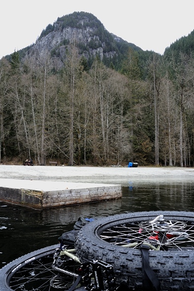
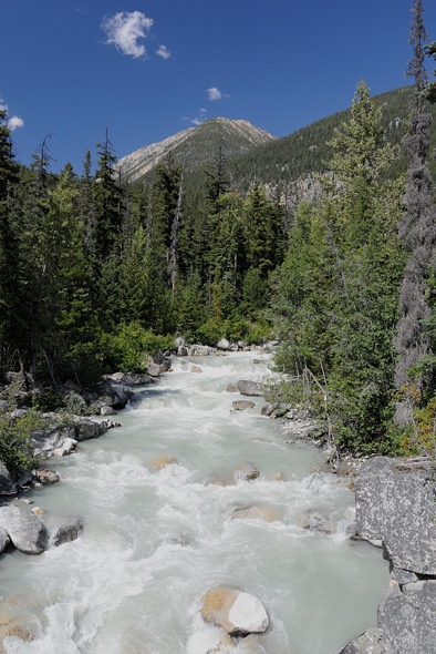
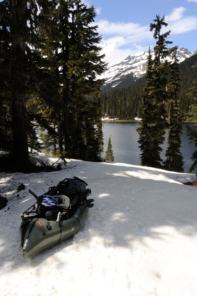
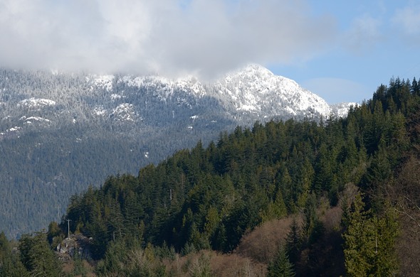
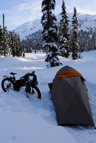
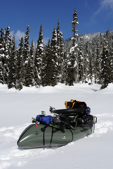
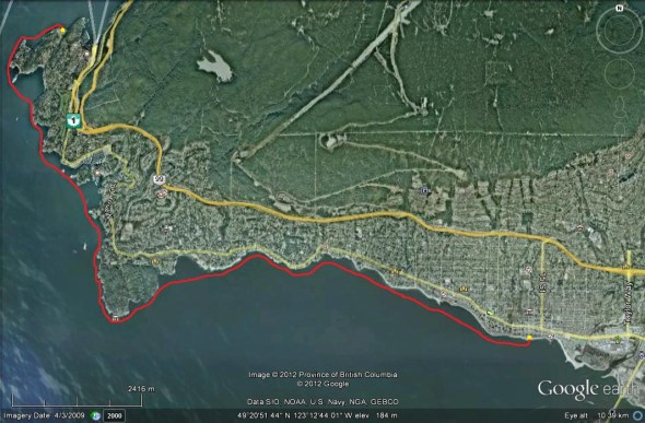
Packrafting / Fatbiking Buntzen Lake
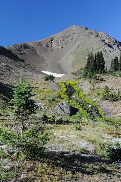
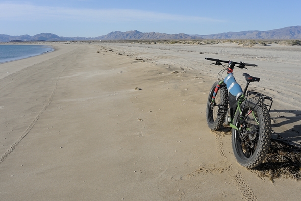
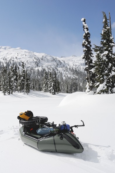
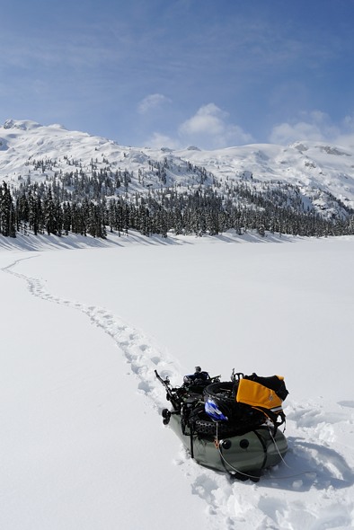
I took my new Pugsley out to Buntzen Lake this weekend. I wanted to try out the bike on the packraft but didn’t want to get salt water over everything, and Buntzen is the closet place you can do that without dealing with whitewater in the North Shore rivers. I paddled down the lake with the bike on the raft, then biked back with the raft on the bike. It worked well. It was in part preparation for my upcoming Mexico trip (I’m going to try Salsipuedes Canyon again), but also it’s just great to get out there and have some fun!
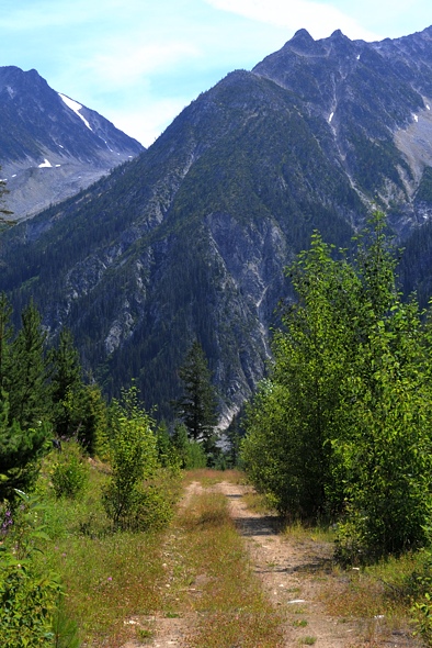
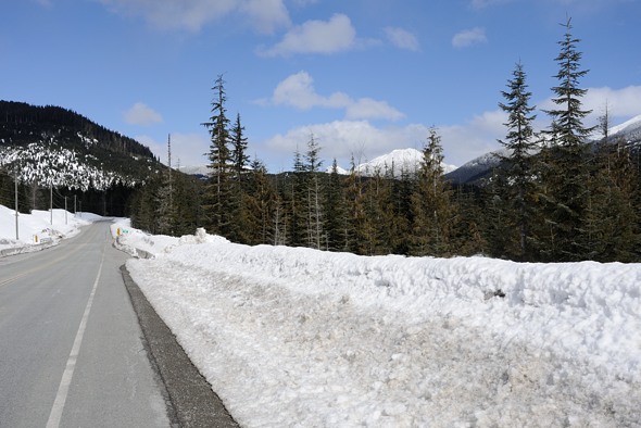
This is a nice area just outside Vancouver. It is a gateway to a lot of very rugged back country terrain. Technically you aren’t allowed to overnight here, but I’m sure if you hike back into the boonies no one would know or care. The issue is the parking gates close at night and you aren’t allowed to park overnight.
I got there after lunch, using up about a third of the charge in my car to get there. I had no heat, to conserve battery, and it was just above freezing. But I was all bundled up. While getting the bike together a BC Hydro truck pulled up and and asked if I was going out overnight. I said, “No, I’m just going up for the day.” “Well you look like you’re going camping”. “No”, I replied, “that’s an inflatable boat on my bike”. Oh cool, well have fun! “Sure,” I said, “the gate closes at 6 right?”. So I had a few hours to go up the lake and back.

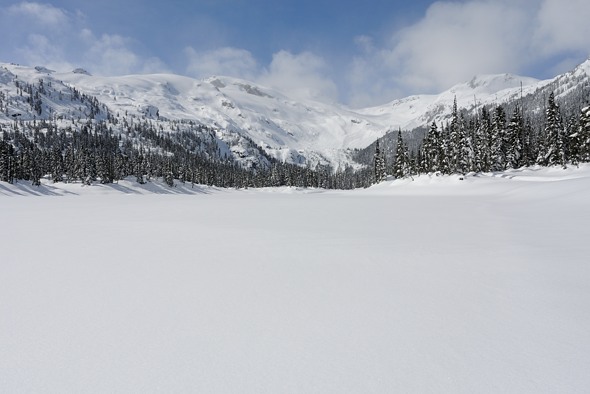
I rode out onto the dock to do the switcheroo. Last time I was here was last winter. It was about the same temperature but blowing hard. It wasn’t pleasant out on the lake that time, especially since I had to paddle back into the wind.
Everyone looks and asks about the bike. That day I had three people ask if the bike is “electric assist”. I’m not sure why. That’s one of the biggest drawbacks to fatbikes, is the attention they attract. It’s fine up here since I love talking to people about all this unusual equipment I have, and to spread the sport. But in certain parts of the world, you really don’t want to attract too much attention.

It’s a little lop-sided with no one in it.

Thankfully there were lots of interested people around who were willing to take my picture.

I had a pleasant 45 minute paddle down to the end of the lake. It was spitting a few snowflakes but didn’t amount to anything. Near the end a headwind picked up but I just hugged the shoreline.
At my destination, the dock at the other end of the lake. Another guy came down to ask me about it, and asked if it was electric assist.
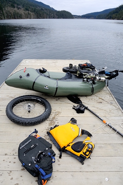
No wet feet at all this trip!
Back up and ready to go. I’d cross that bridge and take a multi-purpose hiking / horseback riding trail back. You aren’t allowed to paddle past the bridge as that leads to the intake for the hydroelectric penstock which goes down to the power station on Indian Arm.

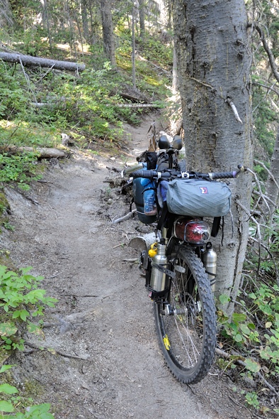
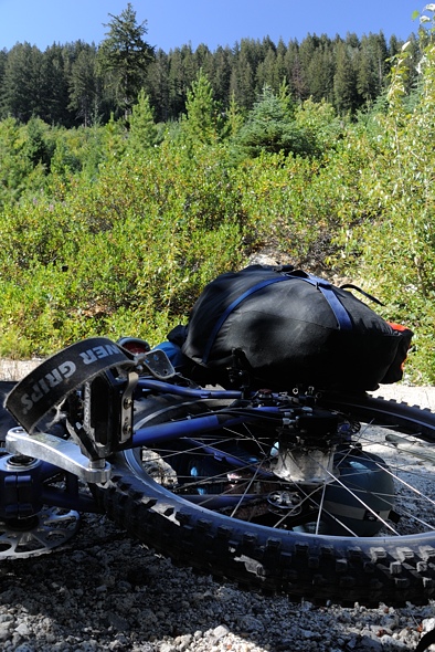
I took the “Lakeview Trail”, which actually only had about one view of the lake, filtered through the trees. It is fairly steep, going up and down along the ridge back south. It was nice forest and somewhat technical. Despite all the gear, the bike remained nimble; mostly due to the weight on the front being centred as close to the fork and bars as possible. I had the tire pressure too high but that was OK because I wanted to see what would rattle off, having just been put together.
During the ride I noticed that something seemed loose in the pedals. It got worse and worse and finally I decided to take a look. The crank arm bolts were coming loose! I tightened them up no problem but I hope the trail grit that was sticking to the grease doesn’t cause any issues. I’ll spin it really carefully at home to listen for any grinding.
This Gopro mount works pretty well. The others I tried vibrated too much; I’ll have to brace them some more.
..
Before I knew it I was crossing the lake on the floating bridge and back by 4:30. They even had a bike wash station beside the parking lot!

I took off the left pedal and front wheel and threw the bike in the back, and proceeded to drive home heat-less.
All in all, a great time was had by all, and all was me.
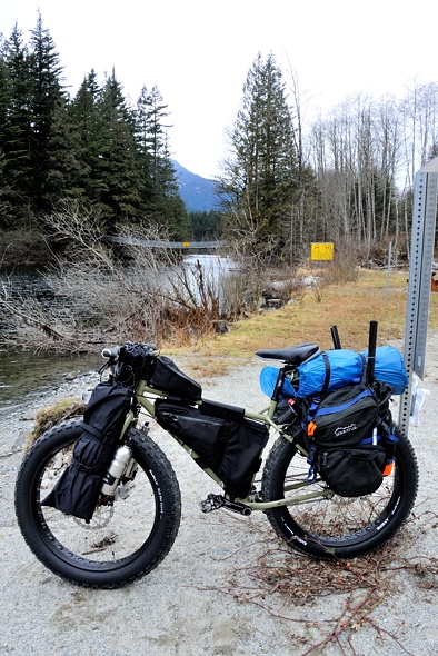
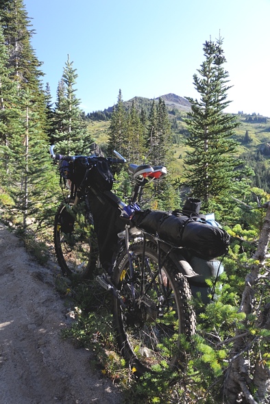
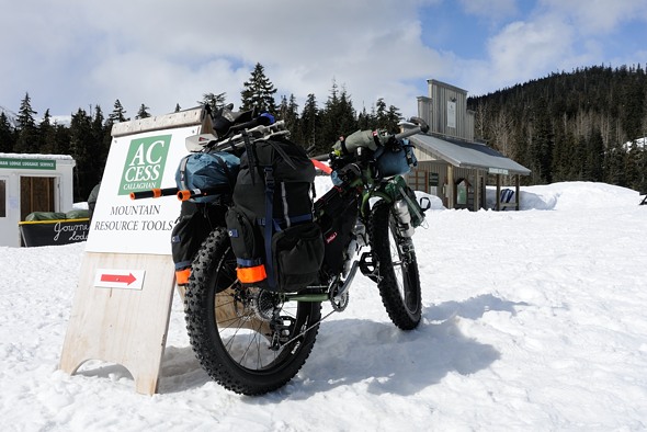
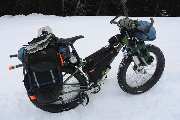
My New Surly Pugsley Fatbike Build
In previous posts you will see a Salsa Mukluk fatbike that I took various places, generally cold (snow) or hot (sand in Mexico), and not much in between. My friend Mark in California decided that he wanted a fatbike when he tried it out and had a blast with it on the dunes and beach. He will use it for beach combing down in Baja. I wasn’t too keen on the aluminum frame material of the Mukluk, or the small frame triangle, or the 170 mm rear hub, so I sold it to him and used the proceeds to buy a Surly Pugsley frame only that I am building up right now (almost the same as Cass’ new rig). It has a Shimano Alfine 8 internally geared rear hub, and I would like to use a SON 28 dynamo hub up front for charging the electronics (the solar panel works in a kayak but is less than ideal on a bike…), but the front hub width is 135 mm on fat frames (same as the back on the Pugsley), and that dynamo hub in the 135 mm version is not cheap… so for now I will use my old XT hub.
Below you can see the racks I am using. On the front I made my own out of a 3/8” aluminum rod I bent using a propane torch. Then I drilled a hole in the bottom of each leg to bolt it onto the fork. There isn’t much metal left after this hole, so I fear it may break at some point. Instead, I will try it again but I will curl the bottom of the rod around into a circular eye through which the bolt feeds. That way I am not reducing any material in the rod. You can see how I did this with the rear rack in the last photo.

..

I really like this front rack setup. It is very light and simple and allows me to strap larger but lighter items to the side. They nest in against the water bottle holders. On one side goes my rolled up mattress, and on the other goes my sleeping bag. On top I can also put a smaller item, and mount a GoPro camera off the front. The other benefit of this setup is that the weight is as close to the turning radius of the steering tube as possible, which reduces the effort required to turn the handle bars and makes for better handling (basically, take a wooden broom handle and notice how easy it is to spin it along its axis than along its length). That is also the benefit of having the two water bottle holders aimed backwards 45 degrees (besides not sticking out so far); the weight of the water is closer to the steering pivot. The traditional setups with front panniers way out the front of the wheel on their own dedicated racks are not only heavy, but not an ideal weight distribution. They might work for road touring but not for the kind of rough off-road bush thrashing I tend to do which needs nimbler handling. And this setup does work; the Mukluk I used in Mexico last month (see link to my Baja Nomad blog writeup) was also set up this way and it was quite nimble on the steering. I also used a Revelate Designs Harness off the handlebars to hold my Tarptent Moment. It didn’t seem to degrade steering too much.
In the rear I have an OMM front Sherpa rack which perfectly fits the Pugsley offset if you put one leg on the inside and the other on the outside. It is too small to carry panniers without them getting caught in the wheel, so I had to put an additional aluminum rod there as well to provide extra support for the panniers flapping around.
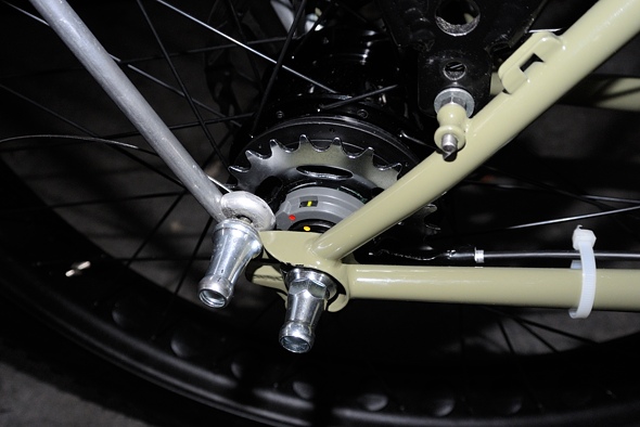
I added some Extrawheel mounting nuts to the back braze-ons. Usually these replace the axle nuts. But this will not work with the Alfine 8 hub on the Pugsley, because it has a solid axle, not hollow with a quick release skewer, and there is not enough thread sticking out the side to add enough spacers to un-offset the offset of the hub and allow for the trailer fork to clear the rear tire symmetrically.
It is size medium, which in retrospect may be a bit small. I probably should have gotten a large, which also allows for a larger frame bag. I am not too keen on Surly’s new style with the lowered top tube and little triangle gusset at the seat tube. They did this to reduce standover height, to protect your delicate bits if you fall off, but I have never needed it. I’d rather have more frame space.
I found on my Mexico trip that the fat rims and tires felt very sturdy in rough places where I was hauling the bike over tortuous rocks. I’m sure I would have whacked narrower rims out of true in some of those places. So I generally prefer fatbikes for all kind of off-road touring, not just snow and sand. They aren’t the fastest bikes around but on my trips an extra 5% speed on the flats isn’t going to make much of a difference. It’s the rough spots that really add to the time and that is where a fatbike shines.
I have dreamed and measured up my own fatbike frame that I may get a local frame builder to build up for me if I ever get the disposable funds. It would be a symmetrical 135 mm build, not offset like the Pug. Surly uses the 135 mm offset to prevent chain rub on the fat tires when in the lower gears of the rear cassette. But if I run only an internally geared hub then the chain would never be shifting and this would shave off quite a bit of space. The only downside is that you’d be limited to IGH’s and single speed setups, which is not a problem for me because I really dislike using derail-yours on my bushwhacking bikes. Without fail they bend and cause headaches.
This ideal setup could accept even a Surly Lou tire (5”) on the back. The advantage of making it symmetrical in the back is that it is easy to swap out the front and rear wheels, with the symmetrical Surly Moonlander fork I’d be running up front which can accept the largest Surly Bud tire for snowbiking (the true Surley Pugsley fork is offset to allow for swapping with the back, but it will only accept up to a Nate sized tire – 4” or 1 inch narrower. Apparently you can squeeze in a Big Fat Larry but I don’t think there’s much clearance). The other advantage of running symmetrical is that I could swap in more traditional narrow 29” tires (you can’t do this with an offset rim because you don’t get enough dish with the spokes to allow for a strong wheel build – you need a wide rim to allow for offset spoke holes, and a wide rim will not accept a narrower tire). That way I could have one ultimate expedition bike that I could use for any tour, fat or not.
So it seems to be coming together well, and Mark got his fatbike that he loves for beach combing. It all seems to work out in the end…I’ll add more info and photos when it’s actually finished.
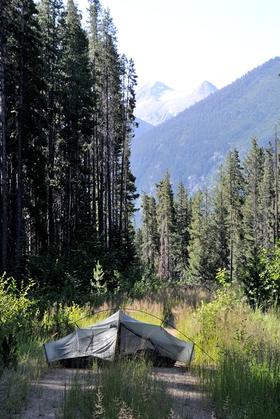
Salsipuedes Canyon by Fatbike
Just a quick Note. Tomorrow I go into Mexico and I’ll start my fatbiking trip down the Salsipuedes Canyon. I started a couple forum threads on it so you can read those, I don’t have much time right now. Also you can follow my progress on my Spot GPS page from the link on the right.
http://forums.bajanomad.com/viewthread.php?tid=70746
http://forums.mtbr.com/fat-bikes/salsipuedes-canyon-fatbike-891993.html
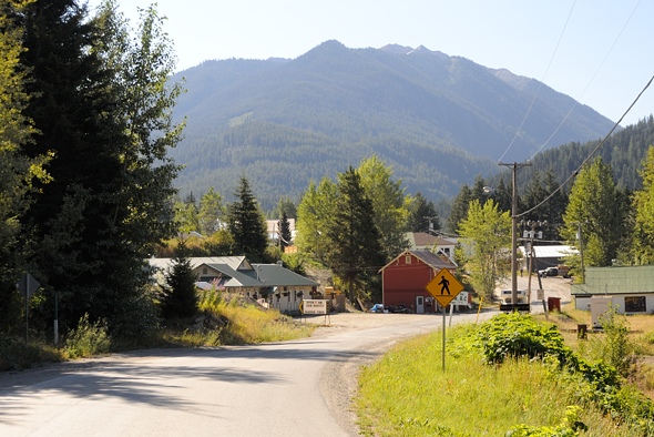
Bridge River Recon Part 3 — Chilcotin Mountains Park
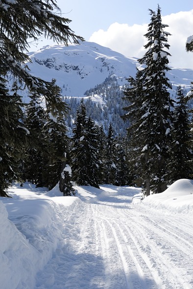
The next morning I went into Gold Bridge.

The east end of Downton Lake at the dam
There is only one store in town, which was closed for restocking. I wanted some gas and apparently the other small town of Bralorne, 10 km up the hill to the south, had some.
I went up there but there was no one around, so I went back down, having used up some gas unnecessarily. But Bralorne is an interesting little mining / tourism town. Mountain biking is big here.

Apparently they produce a kg brick every few weeks.
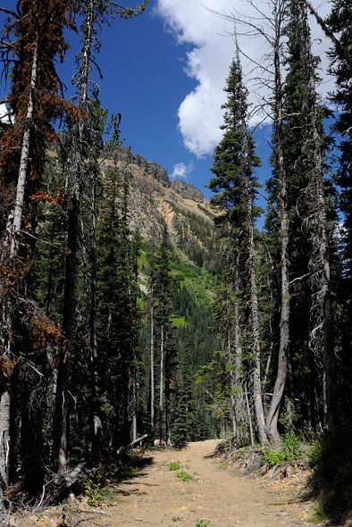
I decided I’d spend a night or two up in Chilcotin Mountains Park above Gun Lake.

Ready to head out. The insane flies sure helped the motivation to get moving. I saw on the map that the Lick Creek Trail went up into the mountains in a fairly straightforward path.

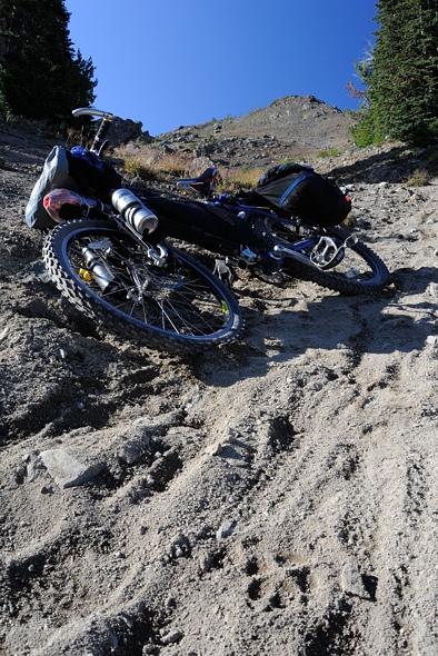
I soon discovered that it was a short distance on the map for a reason — it was super steep!
I pushed and pushed and pushed, huffed and puffed, uttered a few curses, strained and grunted and forced my bike up and over each obstacle. The trail was narrow, rutted, loose, and very steep — I guess that’s why it’s such a highly rated downhill ride. I passed one group of bikers heading down. I asked how far it was — I was barely a quarter of the way up. They were incredulous, as was I.

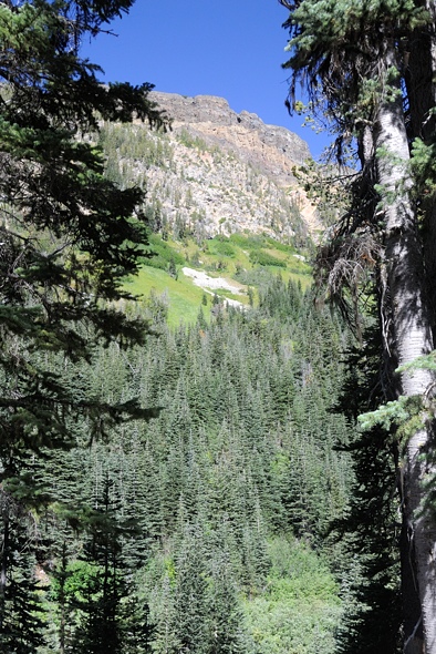
Finally near the Lick Creek headwaters it levelled off a bit in this interesting yellow lichen-encrusted forest.

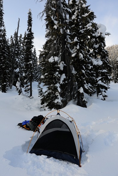
I set my tent up here. Man, I have to say, that was the second most physically gruelling thing I have done in my life. I pulled my loaded bike up 900 m to 1920 m elevation, but the trail was so unbelievably steep I had to do the last 300 m of the climb twice — once with just my heavy gear, and once again with my bike and remaining gear. So I did 1200 m. I am so glad to have my body back.

While in my tent eating dinner, I heard a large mammal outside.

..

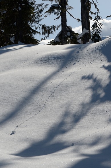
While doing the final packing of my bike next morning, I happened to scan up and this funny-shaped tree stump caught my eye… He didn’t seem to be at all bothered by me. He just watched. Maybe he was following the deer that went by last night. It’s at times like this that I wish I had brought my dedicated wildlife lens, not the mid-telephoto zoom.

I was packing up in the lower meadow in the centre, and the wolf was watching me from another meadow behind the trees on the very left. Also, you can’t really see it because it’s blown out, but there was a forest fire on the other side of the valley there.
Another 150 m of climbing was in order for this morning to get over the pass into the next valley.
..
I had to take my pedals off, which really helped on the narrow trail. I was back to doing two loads…
Amazingly, someone even brought a horse up here.

From whence I came

Finally, over the pass at 2050 m, looking down into the next valley I would descend a little ways into, then meet up with another trail heading right (east) up and out again over into the Pearson Valley.
I have quite a bit of video of the rest of the ride which I’ll add soon, but right now I have some more pressing things to sort out … details to come.
My wolf friend was also using this trail.
It was a shame I had to ride over his tracks but I had to move too.
..
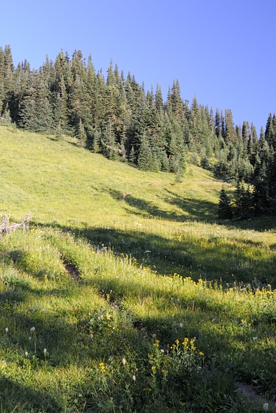
The meadows going up over the pass to Pearson Creek were like paradise … except for the man-eating bugs.

..

..

..
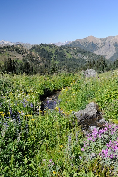
At the time I didn’t appreciate it, because I was being eaten alive, but each of the alpine flowers had a whole community of insects associated with it. This place was like that wonderland you read about in ecology textbooks, with sunshine filtering through colourful meadow flowers, and all the birds and bees associated with them.

..
..

Looking back at another 150 m of climbing to regain the elevation I had lost.

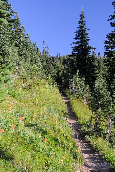
Finally … lunch at the pass, and High Trail going down Pearson Creek.

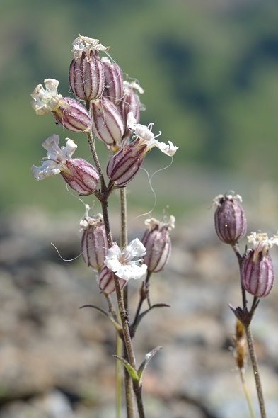
These little flowers have delicate colour patterns on their petals. You just don’t notice all the intricacies going on until you review the macro shots later. That’s a good lesson I think, to stop and smell the flowers in life. There’s lots more going on around you than you may realize.
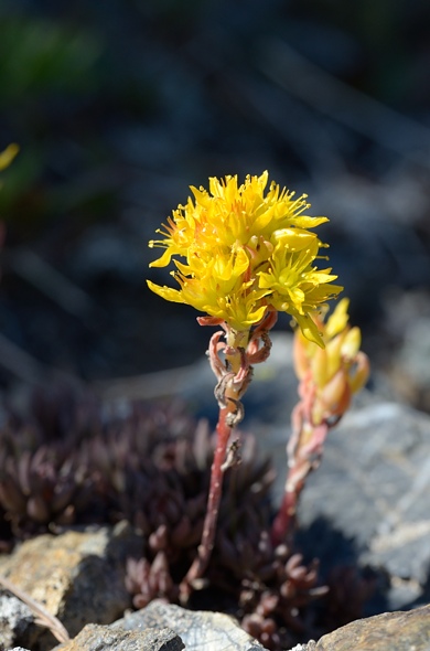
Stonecrop
..

I had 1000 m of descent ahead of me.

I passed a couple going up (look closely). They were going to go down Lick Creek trail. They were only up for the day, so much less heavily loaded than I was. Everyone up here is super fit; how else do you get up here?

..

One of the more inviting trailheads I’ve come across in my tavels… but I was going down.

Near the bottom of the hill, after all the mud and dust. That sure was a fun descent, but I screwed up my left thumb for a few weeks from all the braking I was doing. I loaded my bike too heavily; it was not performing as I would have liked. I passed another couple going up for a few days and I couldn’t believe how light their kit was. They had backpacks, and plus it helps to have two people, as much of the gear can be shared.

I passed through more hot and dry grassy douglas fir stands.
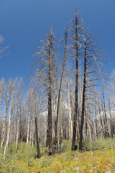
On the way driving back out, I went by this recent burn.

All clean after my bath in Mowson Pond.
Bridge River Recon Part 2
Another day, another bike ride…

I found this guy slithering down at the stream in the morning.

I set off and soon came upon the first clearing and a deer. It had at least four sucking deer flies, two on its snout. Unfortunately for the deer, they can’t swat them off as easily as we can. Somehow they manage to survive without going crazy though. At least at night the flies go to sleep too. It didn’t take off so there must not be too many hunters up here.
The road climbed up the north side of the valley. It was really hot in the blazing sun. But I knew that I only had about 400 m of climbing to do and it would only take a few hours so I plodded on. I was mostly pushing my bike.
Then the character of the road changed. I was at the end of the forestry road and the beginning of the mining access road. It became narrower and more like a quad track, but still passable for a good 4X4 with a short wheelbase. That mountain is on the other side of the river I wanted to cross. I was actually hoping to get up on to the summit of that alpine plateau there, but I’d have to go way up the valley to get to terrain suitable to climb up.
At the end of the road I found this!

I’ll take it thanks!
Here is a better view from the cabin, across the valley. The river is canyon-like here and too dangerous to cross. And there’s no way I’d be able to drag my gear up that slope. So I’d have to go up to the head of the valley where the river is flatter and the sidehill more gentle.

A hundred meters past the cabin the road ends at a picturesque debris chute (which I didn’t take a picture of).

The penstemon and lots of other flowers were in bloom. The river is glacier fed and silty and therefore not good for filtering as it would plug up the filter element. And it was cold too. But the little stream in the debris chute was clear and warm, not being glacier fed and tumbling down 500 m over black rocks roasting in the sun. It was warm enough that I could have a comfortable splash-bath.

There are interesting hoodoos at the top of the debris chute. There are also some lakes above on the alpine plateau. That’s all whitebark pine at the higher levels. It grows thick here.
I decided to use the cabin as a home base to check out the valley. It was soon apparent that I wouldn’t be able to do my trip in the one week I had off, unfortunately. It would just be too hard to pull my bike up the valley. I thought the road went further up. Tomorrow I’d go hike up the valley to assess just how difficult it would be. So I spent the rest of the day R&Ring.
The flies are attracted to the heat so when I made dinner they were swarming all around and afterwards the stove was full of dead fly carcasses. It reminds me of a funny story from treeplanting in Alberta years ago. You’d think that being the foreman would be the best job — you don’t actually have to do any real work. It’s the planters who are out there grunting in the trenches. Well in northern Alberta our foreman whipped around on a quad checking everything out and hauling boxes of trees around. And of course, the horse flies and deer flies are attracted to heat and CO2 … both of which the quad was producing copious amounts of. So whenever he’d pull up he’d have this massive, I mean massive, cloud of horseflies following him and he couldn’t outrun them. It was pretty funny.
Anyhoo, that Thai Satay dinner was one of the best ones I’ve had in a while… everything seems to taste better when you are pushing hard and need the calories. It started to hit me how isolated I was. With the road closure I had the entire valley to myself. I was a good 60 km by road from the closest person, maybe 30 km as the crow flies if there were campers up in South Chilcotins Park to the north-east. It’s easy to write, “I was totally alone”, but a bit different to actually experience it. It wasn’t a bad feeling; just something I don’t often experience except on these little adventures I do. Few people get to experience that kind of isolation; it’s worthwhile to try to get it IMHO.
In the evening I lay down on my Thermarest on the plywood bed and listened to music on my iPhone. As it got dark I looked out the small window to vaguely see some stars poking through the trees. I wondered about what the chances were that those particular photons, merely a handful of the quadrillions of quadrillions produced by that star who knows how many light years away, happened to travel through so many unbelievably many kilometers, over such a long time, all the while ever-expanding and diluting in intensity to the square of the distance travelled, and somehow manage to get through the atmosphere, between the fir trees above the cabin, through the smudgy little window, and into my eyes and onto my retina, just at the moment I was thinking about them and looking. What journey must that be like from the photon’s perspective? Or is there such a thing as a photon’s perspective? Maybe that reality of the starlight making its way to my thoughts via my eyes only existed because my consciousness brought it into existence. If I wasn’t alive to observe it, was there even any starlight there to see? How is the star any different than me, if it’s all just “One”? I think I need to do some Buddhist practising out here on these trips…
And now back to “reality”:

The next morning (well, more like lunch time) I hiked up the valley. There is a deer trail that is fairly easy to follow. Basically you keep as close to the edge of the river canyon as you can and you’ll find the trail if you lose it. I was encouraged to see that the terrain wasn’t all that difficult, except for a few tricky areas that wouldn’t be too much of a problem.

The trail alternated between forested areas and open clearings like this.
 ..
..
In places I would have been able to ride my bike.

Stonecrop likes the dry areas.

Looking across to the west side of the valley. That green meadow really is a meadow. It’s like your front lawn.

The light green areas are the grassy meadows, easy to walk through. But these are interspersed with willow thickets that get up to head height, substantially more difficult to walk through. Not a problem if you’re just walking but pushing a bike would be a bit more of a challenge. But if you took your pedals off and turned your handlebars it should be do-able.

Looking up to the head of the valley.

The willow got thicker as I went further up the valley. I went about as far as I felt like going and did some more assessment of the hike up to the alpine. I’d cross the river around here on my packraft and then hike up through the forest at the far end. The willow looked thick, but at least it’s not spiny like devil’s club. The vegetation here is all pretty benign.

I’d go through the forest and emerge in that meadow at the top left.

The flies were driving me nuts but I took out my macro lens and managed to pull a few shots off. If I stayed still for more than five seconds they’d attack me.
And now, for your viewing pleasure, I have put together a video montage of my trip up the valley, including some narration from myself.
..  I hiked back down the deer trail to the cabin. One person with a saw and clippers could clear a nice trail up that valley in one day. I was disappointed that I couldn’t do my circuit, but what did I expect? I’d never been here before. This was a good scoping-out trip and if I had two weeks I would have been able to do it. Hopefully in September I might be able to get time off and do it then. Otherwise, next year.
 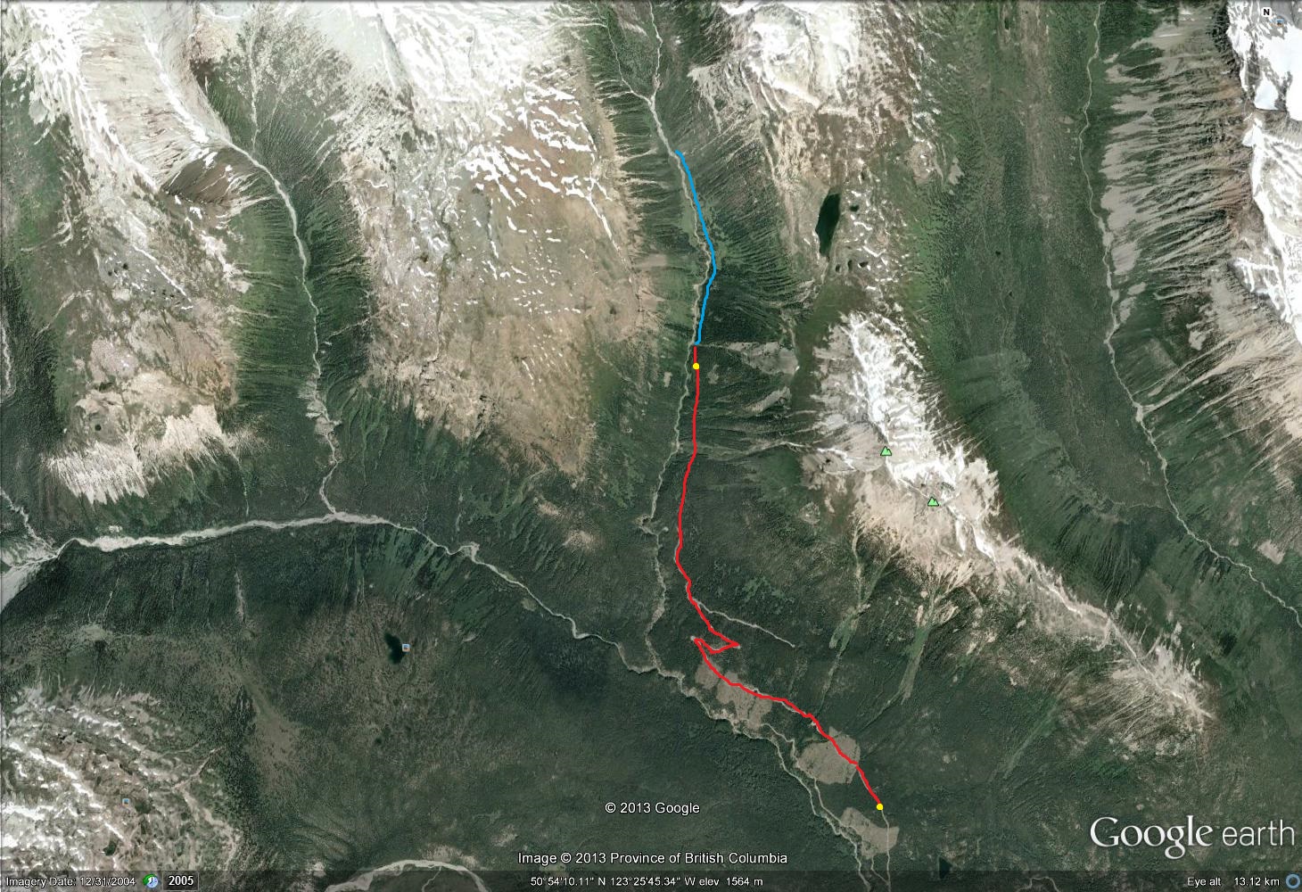 ..
..

The next morning I headed back down.
I was going to try to get all the way back to the car. That was almost 50 km, with 1300 m of descent and 300 m of climbing.

Looking back up to the upper Bridge River. There is a big icefield up there.
At lower elevations I went through these nice grassy park-like lodgepole pine stands.
 ..
..
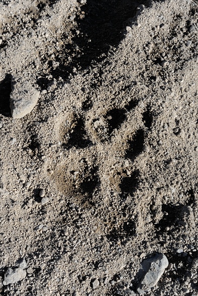
Fresh wolf prints were left on my tire tracks from two days before. The grizzly tracks were gone, suggesting that when I saw them they were fresh. I felt like Mantracker, analysing all the tracks I was seeing.

Looking back up the Bridge River. It was like paradise.

There’s even some ponderosa pine here, which likes it hot and dry.
This is western white pine.

There’s lots of wildlife even up here at these higher elevations.

At the Bridge River Bridge is this new building which seems to be some kind of a camp. I took refuge from the bugs there and had some peanut butter on mango.

There were also some more bear tracks here, but this time going my direction so I was coming up behind him. They weren’t very big though.
 ..
..  It was a long day but the kilometer countdown to the car kept me going.

Finally I got to Jamie Creek.

Big steel pipe with 1 inch thick walls.

I made it back!

Right across the road was some seepage where I could fill my bottles without filtering.
Here is another video montage of the trip back down, including a demonstration of how to get your bike over a penstock.
..
Bridge River Recon, Part 1
Like usual I scrambled to get out Saturday morning, not leaving till after lunch. I really need to get packed up a week beforehand so I can just do a final check the morning of, and go.

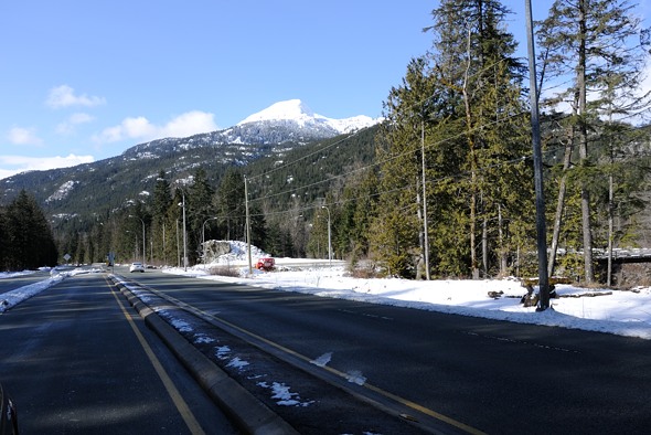
At Pemberton I turned west and headed up the valley bottom to then turn right onto the Hurley Forest Service Road, which is a fairly rough gravel road that leads northwards over the mountains to Gold Bridge.

Looking back to the thunderstorm that was engulfing Pemberton and areas east. I was worried this might start some forest fires.

The Pemberton Valley is scenic potato country.

The Lillooet River goes down the Pemberton Valley, feeding Lillooet Lake before becoming a river again and joining the Fraser River near Chilliwack, via Harrison Lake. It would be an interesting circuit to bikeraft someday.

The Pemberton Valley as seen from The Hurley.

Looking back down to the Pemberton Valley with cows in the fields.

First views of Downton Lake as I descended the other side of The Hurley.
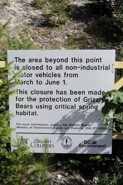
Unfortunately when I got to the Bridge Main going westwards along the lake there were signs saying that the road was closed at km 16.5 due to a run-of-river project under construction.

Near the run-of-river works, as far as I could go in the car.

Looking west down Downton Lake, which is actually a reservoir with a dam at its east end.
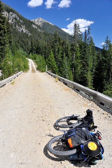
So I camped in my car at the side of the road a kilometer back. The next morning I spent a couple hours getting my stuff together and noticed that I forgot to pack my morning oatmeal packets! I always manage to forget something. At least this wasn’t critical and I brought excess other food. I finally set off and rode up to the construction site. I immediately met the site safety supervisor who helped me drag my bike under the penstock and up the other side. Here is a video of me riding my bike up to the site and talking like a chipmunk. Unfortunately I didn’t keep the video on as I went under the penstock, which would have been the most interesting part.
..

The 300+ year old douglas firs being perfunctorily cleared and thrown at the side of the road to make way for the powerline right of way.

A better look at the substantial run-of-river project scarring the landscape.
What all the interest is about: Jamie Creek, which presumably doesn’t have any fish in it.
Once over the penstock, I was off. And I had the whole place to myself.
The ground and soil was wet from recent rainstorms. There were butterflies lapping it up and I rode through bursts of colour. I didn’t take any photos though since I was tight on time and their colours didn’t show when they were on the ground with closed wings.

I was stopping every few minutes to eat copious amounts of thimbleberries, which are very sweet and tasty. And there were a few wild raspberries too. Maybe there would be enough berries to make up for my missing breakfast oatmeal.
Here is a GoPro mount on the front fork. It’s a shaky spot but a good view. I’ll have to mount it more sturdily so it doesn’t vibrate.
..
Here are some more videos. I know they’re shitty but they give an idea of the terrain.
..
..
..

Poor little bird with a broken wing. There wasn’t much I could do.
..

This is at the end of Downton Lake where it transitions to a delta. This is a small provincial park with lots of wildlife (but no bears this time of year). Boy I sure am skinny, eh. But that little body can do some amazing things…
The road began to climb… and climb. I was not thrilled about having to gain over 300 m and then lose most of it again to come back down to the river (although it’s all about expectations. I was expecting a nice flat leisurely riverside ride).

On the descent I caught a glimpse of the Bridge River Bridge at 38 km.

The views opened up to reveal the lush green valley. This is a really beautiful place.

The tree species diversity here is high. It is in the dry douglas fir zone on the east side of the mountains. And since the valley runs east/west, on the north side of the valley you have plants adapted to heat and dryness, while on the south side you have more shade and moisture adapted species. Here on the valley bottom were some larch on the left, spruce on the right, and big douglas firs in the back right. In the foreground are thimbleberries. About the only tree species missing are hemlock and yellow cypress.

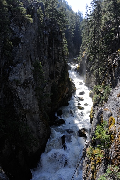
Crossing the Bridge River. It is raging here.
..
..

The ride immediately got hotter as I was now on the north side of the valley in the blazing sun. I was really low on water and starting to cramp but thankfully there was a stream a half kilometer past the bridge.
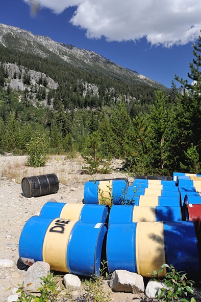
I plodded along and came upon this stash of diesel.
This is Nichols Creek, which is the valley to the east of the unnamed valley I was going to go up. The bridge over this creek is in rough shape, I don’t know how much longer it will be drivable. That creek is too dangerous to cross without a bridge. And the road is deactivated at this point so if the bridge goes, who knows if it will be replaced.
I just kept hammering in the heat. The scenery was very beautiful, but I can sometimes tune out where I am if I am doing intense physical activity. Here I had reached my limit and had to take a break to eat some food and drink some water. I was using Nuun electrolyte tablets in my water which seemed to be working and keeping the cramps away.
The flies were really bad. They were both deer flies, which are pretty big and take chunks out of you, and also smaller house fly-like things that, unlike house flies, bite you. I had to pitch my tent to get away from them for half an hour. While lying there looking at the swarm of flies on the screen of my tent, I noticed a deer fly preening his appendages. Then, seconds later, a wasp came by and grabbed him and ate him on the spot, on my tent. It only took a minute to turn that preening deer fly into mince meat.
This is what I ended up doing on any significant ascent:
..
I continued on and was concerned about bears. The problem was all these berries at the side of the road where a bear could be hiding, blissfully unaware of my approach until I was on top of him. And the wind was blowing against me, coming down from the mountains from the west, so a bear wouldn’t smell me. Plus the wind was noisy so he wouldn’t hear me either. My bear bell was pretty wimpy, and really more suited for hikers who move much more slowly. I yelled every time I approached a corner.
I came upon this set of prints from the King of the Valley walking in the opposite direction I was riding, meaning I had already passed him. I’m not sure if he heard me coming and took off or just left the road before I came by. I guess I’ll never know… Luckily we didn’t meet. That was a BIG bear.

With the road blocked off there was no vehicle traffic. The wheel tracks became highways for wildlife, covered with deer, wolf and bear tracks.
I stopped to filter water at this idyllic little stream. You can’t really see it in this picture, but the flowers were really pretty.

My loaded rig.

I was mostly climbing in elevation, going up the northern side of the valley. This is looking back to where I came from.

It is a very scenic valley.
I called it quits for the day, about 5-10 km from the end of the road; I wasn’t quite sure how far it went. I found a nice spot where it levelled off and was near a stream. No worries about blocking traffic here…

Camp just happened to be at the 52 km mark. I started at 15.5 km that morning, so I did 36.5 km that day. It was a hard ride though, with the heat (30 C +), and altitude (1100 m), and total elevation gain of about 800 m including the little escapade up and down the other side of the valley. Plus I had the weight of all my gear. I was pretty beat and didn’t sleep very well because of that.
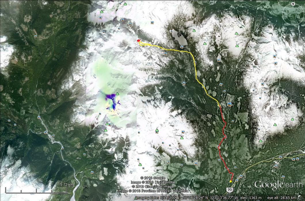
Chilcotin Bikerafting Route
On Saturday Aug 3 I should be starting my 8 day bikerafting trip through the Chilcotins. Here is a route map:
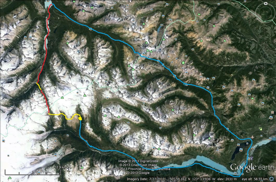
I’ll start at the big yellow dot. The first part will be an alpine hike-a-bike (yellow) westwards over to a river valley heading north. Then I’ll packraft (red) a few kilometers down this. This enters the Lord River valley via a big steep waterfall, so I’ll have to bushwhack (yellow) a km or two down to the valley bottom. Then I’ll packraft 20 km northwards down the Lord River and the smaller lakes it goes through (red), finally emerging at the south end of Taseko Lake. From here there is an established trail (blue) going back to Gold Bridge via Warner Pass.
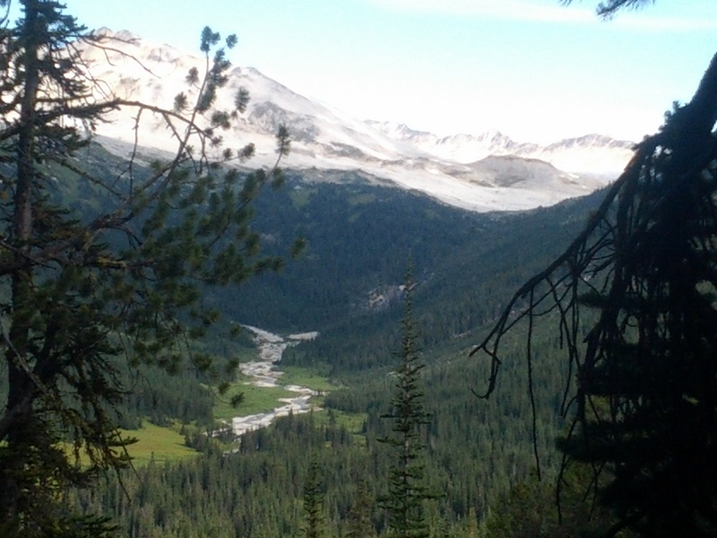
There should be lots of grizzlies and bugs, and epic views. The safe aspect is that I’ll be attempting the hard parts — hike-a-biking and packrafting — first, so if there are problems I will have time to get out. The very first part is up that side valley to the north of the Bridge River. The road goes further up than Google Earth shows, apparently. I found this report from a trip that headed east up from that valley into the alpine. I’ll be starting from the same place, but heading west up into the alpine. This photo was taken looking northwards, right around where the yellow dot is:
I tried to line up Google Earth with that:
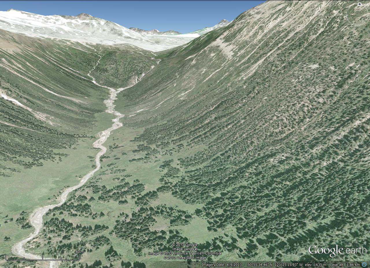
I’ll head up the creek to the end, and then go left up the western fork up to the alpine. Then I’ll turn left and head west over the alpine. Doesn’t look too hard … I’ve said that before!
You can follow my progress on my Spot GPS map page. I’ll update it every night.
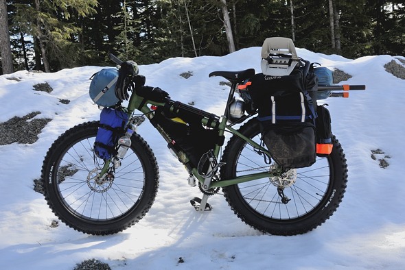
Here is my beast:
(no time to take a photo, I’m leaving in a couple hours — I’ll post em up after)
Front fork:
- 2 water bottles
- alcohol bottle
- bear spray
- water filter
Handle bars:
- Tarptent Moment
- two “Mountain Feedbag” stem bags with lunch inside
- maps and other small items in the pocket in front of the tent
Frame:
- “Gas Tank” bag on top tube which has my Nikon V1 and flash
- frame bag has stove set, clothes, tool kit, and a few other things
Rear rack:
- packraft goes on top, with paddles strapped to the sides
- innertube and piece of spare tire are strapped to the rack mounts by the seat stays
- tire pump mounted on top of rear fender by seat stays
- Thermarest mounted under rear rack, wedged in above fender at the very back end of the bike
Pannier
- food, some other clothes, electronics, all other miscellaneous stuff
- Zipshot tripod mounted on rack / bike frame beside pannier
Other side of rack:
- sleeping bag lashed directly to rack
- solar panel mounted in an Ocean Spray bottle right beside this
May 25 to 28 — Long Beach, California to Alfonsinas, Mexico
This year my two week vacation was to Baja California with my friend Mark and his family in Long Beach. Kayaking the BC coast will have to wait until next year (but I am planning a big 8 day bikerafting trip through the Chilcotins in August, so stay tuned — hey, that’s in a week!)

The flight goes right by Yosemite.

Mark picked me up at LAX, then we ran some errands, including going down to the Marine Institute at Los Angeles Harbour…

… to pick up a bottle of Nitrox we’d use to refill the tires at some point on the trip, after we leave the gravel and get back on pavement (for a smoother ride off road, you air down the tires. But this low pressure isn’t good on sealed roads).

First wildlife sighting of the trip.

Long Beach

Feral parrots are still living in the palm trees at Belmont Pier in Long Beach, right where I used to live.

Getting my stuff together at Mark’s house. We left 3:30 Sunday morning to avoid freeway traffic and to arrive at our destination not too late.

We zoomed down to San Diego, then turned east on Interstate 8. Over the pass into the Imperial Valley is windy, and the turbines appeared against the sunrise.

..

Dieseling up at Calexico before crossing the border. I’m a conspiracy buff myself, but are they “chem”trails, or just “con”trails from water vapour from combustion in the plane’s engines? C6H14 + O2 –> CO2 + H20

Marathon in Mexicali

700 km later, we hit San Felipe for breakfast and did some tourist shopping. Here we are, stuck in traffic on the strip.

They are paving the road all the way south from San Felipe. Very sad to see the gravel road go, that was a classic. They want “development”. The problem now is you can’t get off the highway down to the little coves we used to go to.

Finally hitting gravel, and airing down. They have only gotten so far with the paving.

Once across this arroyo with a bridge, the pavement will continue.

Shortly afterwards (150 km from San Felipe) we got to Alfonsinas, which is a spit a few kilometers long that has a row of beachfront houses along it. Alongside the spit is a runway and many people fly in rather than drive.

..

At the end of the spit is a restaurant / hotel. But the tide was extremely high that afternoon so we couldn’t get over (that’s the runway submerged).

Oh darn, we had to wait it out on the beach.

..

Quincy

Finally … dinner.

Looking back down the spit from the restaurant

..

Frigate

These gigantic 2″ wasp things were quite common most places we went.

We didn’t have a proper bike rack so we just lashed my bike to the front grill. I thought I had put padding on all the rub points…

Damn! Missed one! Ouch! That was nasty, but it didn’t seem to be in a critical location. The perils of owning an aluminum bike…
It rides very well on the sand, much better than on snow. The tidal range here is huge, wider than anywhere I’ve seen.
..
..
This one is shorter:
..

The palapa I set my tent up in. There are a few reasons it is open on this side, and closed on the other. One is the view of the beach, and the other is…

That evening, all of a sudden, the winds shifted from a nice gentle sea breeze to coming from the desert, blowing out off the interior. It got stinking hot and ferocious for most of the night. I got to set my brand new tent up in the dark, for the first time, in the windy palapa. I was peppered with a fine dusting of sand that made it through the thatch.
Here are a couple pieces of video stitched together showing the wind and the sand dollars (I don’t have the resources right now to turn them into little movies):
..

The sand dollars are a little different down here.

Up from the beach at the road is a store / restaurant. We were sitting there eating dinner when this monstrosity pulled up.

It was John and Betti from the UK! They shipped it over to Halifax and drove around Canada in winter, then made their way south through the US. They had just entered Mexico en route to South America. One of the first things he said to me was, “You must really love the sun!” If you’ve seen me in Mexico you actually haven’t seen much of me, because I cover up. You don’t want to mess with skin cancer! There’s a reason the Arabs wear sheets. I’m a pasty northerner, I’m not sand people.

It’s a Mercedes fire truck that he converted over. He made the box himself.

Being from the UK, he really doesn’t like Range Rovers. Of course, a whole pack of them pulled up beside us.
We spent a few days at Alfonsinas with some of Mark’s friends from work, and their friends, all marine biology people (all Colombian too). They weren’t going further south though since they didn’t have the time or proper vehicles for it.
Ring Pass, Attempt #2
It was the July 1st long weekend, time to try crossing over Ring Pass again from the Callaghan Valley to the Squamish Valley. I sold my Mukluk fat bike to my friend Mark in California (story to come) so I took my regular mountain bike instead.
This time I drove my electric car up. I went up Thursday evening in the dark and the rain. I brought my generator with me so I was a little careless about wasting battery, and I didn’t even start with a full charge. I camped at the Chase Main where it meets the highway (where the road up to Cloudburst Mountain starts from). The generator wasn’t working properly and after 20 minutes I checked my batteries. It wasn’t charging them, it was draining them! I went from 25 km range left to 15 km! And it was 30 km into Whistler! Luckily I had my iPhone so I could check the internet for towing companies. I wasn’t looking forward to an expensive tow the next morning and I curled up in the front seat at 3 a.m. for 2 hours of uncomfortable sleep.

I awoke at the break of dawn at 5 a.m. to a train rumbling by. I decided I’d just crawl along the highway and see how far I got.
..

Amazingly I got to Whistler Creekside! I pulled into a restaurant at 6:30 and plugged in for 20 minutes. This is the view up Whistler Mountain while I waited.
I felt kind of awkward with the morning guy inside probably wondering why I was plugged into his outlet so I risked the remaining 5 km over to downtown Whistler where there is a proper charger.
I carefully drove that section and as I pulled into the parking lot I lost power, the car totally died. I turned into the closest stall and … I shit you not … it had a plug beside it! What are the chances? It was just a regular 120 V plug, but good enough. I had to charge it for an hour and a half before the thing would even let me move it. But at least I avoided an embarrassing and expensive tow.

Then I went down to the free Level 2 charger at the City Hall. There are also 4 more chargers across the street in the Day Lots (beside those trees on the very left), which are a bit more secluded and shaded. I’ll go there next time.
So I could have made it to Whistler no problem if I hadn’t blared my radio most of the way, had started with a full charge, and hadn’t wasted 10 km with my broken generator!
It would be another 5 hours for a full charge so I went for a little ride around the Whistler trails. There are tons and they range from easy to more technical but I didn’t do too many technical ones. This was just to scope out my bike and gear and deal with any issues. I had just gotten a frame bag which turns out to be too small, but it still works, and a “gas tank” bag that goes on the top tube. My Nikon V1 fits in there perfectly.

Lost Lake with most of my gear, minus my packraft and snowshoes and pfd.
..

..
I finally did some basic video editing but the free Windows Movie Maker software sucks. I’m going to get the Cyberlink Power Director which is much better. But here is a sample of the video I typically get, which is pretty poor quality (the original HD is really nice). This is just the raw footage. Actually making a movie will have to wait until I get my new computer and software sorted out.
..
This mount under the down tube really works. I’ll try to move the camera over a bit to the right so the tire isn’t right in the middle and you can better see where I’m going. It’s a lot harder to mount a GoPro camera on a bike than you’d think. The issue is vibrations, so it needs to be very sturdy, on a short mount. Plus, anything on the front wheel or handlebars swings too much from left to right. So what are you left with? The down tube, and your chest, basically, and a few other interesting locations that don’t really show the view out the front. Plus when you are loaded with bikepacking gear that obstructs a lot of the views.

This is “disc golf”, whatever that is. Probably some weird legacy from the Olympics.
..

In summer Whistler turns into a mountain biking mecca.
By 1 in the afternoon my car was ready to go, and 5 hours in Whistler Village is more than enough, so I was off, with 11 bars out of 12 on the battery charge. I was heading for the Rubble Creek parking lot at the base of the Black Tusk hike. It is a provincial park so the lot would be good for parking. And I only used 2 bars to get there from Whistler! It’s mostly downhill.

Since I got there on Friday afternoon before a Monday long weekend I got the best spot in the lot — shaded all day, which is important for keeping the car from turning into an oven which is not good for the batteries.
I was off by 3 and headed 8 km up the highway to the Callaghan Valley.

Along the way, the Cheakamus River was raging over the Daisy Lake dam.

At Brandywine Falls there was this map showing the historical native bands. It described them as being excellent mountaineers. I wondered how I’d compare on this trip…

It was very lightly raining the whole way which kept me nice and cool.
When I got to the gravel mainline up the valley the rain picked up, and it got steeper. This meant I went slower. And the mosquitos were insane. That’s one way to push yourself up a hill faster — trying to outrun a cloud of mosquitos! I was maintaining 6 km/hr but that wasn’t enough. 10 km/hr is needed. After an hour the road got less steep so I was able to outrun them.

Taking a few seconds off from swatting mosquitos to look back down the road.
..

..

At one point I stumbled onto a big black bear 50 m down the road. He took off into the bushes.
..

I got to Callaghan Lake and there were a couple other cars there with campers.
..

Callaghan Lake in the rain
I felt pretty proud about fitting all my gear onto my bike; it’s so compact and light … yet functional. I’ve put a lot of thought into getting that gear weight down and I’m noticing the results. I even had my packraft, snowshoes, and pfd on there. But there’s still some weight savings to go…

I set up camp, had dinner, and then went to bed.
I should also mention how my body is turning into a machine. I am amazing myself at how fast I can climb up the hills. All that cycling and Grouse Grind training is paying off. Just put food in, and I get climbing out. It’s good to have my body back. The good part about being up here is that it’s mostly over 1000 m elevation so I get some mild altitude training.

The worst bear cache ever, but at least it got the bags off the ground.
The next morning was partially sunny and I decided to go for a little jaunt on Callaghan Lake. The outflowing river is right beside the campsite.

..

..

..

All the pollen was collecting at this end of the lake.
..

..

The exit from Callaghan Lake

..

Thick pollen
..
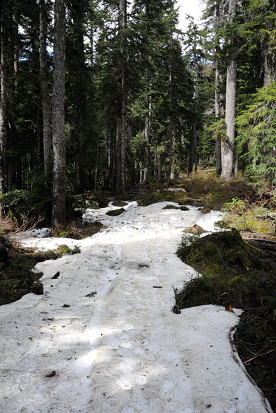
I packed up and headed for the trail I took three months earlier in the snow. Unfortunately it was still half covered in snow, and the trail was narrow and tortuous through the mud and roots.
..
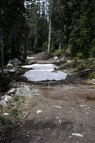
I lugged my bike through a few kilometers of that before finally hitting the main service road up.
..
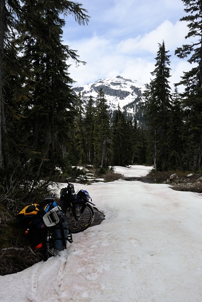
That was much better, but the further I went up, the more snow-covered it was, and it was not easy lugging my bike over the snow.
This is me lugging my bike over the snow.
At the 11 km mark (Callaghan Lake is at about 8 km) I decided to switch over to the packraft but there were still bare patches so it wasn’t straightforward at all. Plus all that red algae stuff that grows on melting snow was accumulating on the bottom of the raft and making it sticky.
I got to the lodge and turned off the trail towards Conflict Lake. I could see that on the other side there were lots of bare patches, being south facing, and that was where I would be going up towards Ring Pass. I could see that the final push up to Ring Lake was very steep and there was no way I’d be able to do it in the time I had. Damn! Thwarted again!
So I decided to set up camp there above Conflict Lake, which was nice. But there weren’t any good spots, and I didn’t want to camp on the snow, it would be too cold.

But wait! I have an inflatable mattress!
..

Perfect!
..

..
Ring Pass. Someday I’ll get there… Maybe in September when there’s no snow.
..

..

The next day I headed back down, along a different trail, the lower “Wild Spirit” trail, which is a rough road suitable for quads. It was hot that day.
..

Summer had sprung.
..

The farther down I got, the hotter it got and the more luxurient the forest became.
This is me riding down a steep section.
..
And the chest mount, which is a bit shakier.
..

Very pleasant riding through 10 km of old growth cypress / balsam / hemlock.
..
Black Tusk over Callaghan Creek
..
Alexander Falls. It’s pretty big.
..

The final 3 km was the steep push up to the parking. The lot was very busy, being a summer long weekend. I timed that well. I decided to push myself as hard as I could up the hill, for training purposes, because I had no more cycling to do after that. It was really hot.
I was pretty disgusting after all that so I went and took a bath in Rubble Creek. Except it was just above freezing. The air was 30 degrees and the water was basically zero. I couldn’t even hold my hands in it, it was too painful. But I could stand in it, and I splashed the water over myself. Man that felt good.
I made it back home with 1 bar left on the batteries, no probs. Hopefully soon they will get the chargers installed at Squamish. They have them everywhere now, except the one place you need them — Squamish. Go figure.
Snowbiking The Callaghan, Whistler
Since my last bikepacking trip up Cloudburst Mountain was so much fun I was itching to get out and try it again. That was a circle route up over the pass and back around the mountain. So I spent some more time poring over Google Earth and found out that there aren’t a whole lot of other opportunities like that for circle routes in that area because most mountains are just too tall.
I went to MEC to get some real maps and discovered that there is a route leading from the Callaghan Valley (near Whistler) that goes west over a pass by Ring Lake and then down logging roads into the Squamish Valley. Great, I’ll just have to wait until August…
But … I just got my snow bike… so I can handle some snow. It won’t do powder but packed trails are OK. And I also have snowshoes, and a new packraft. So I decided to plan an adventure for March instead. My hope was that if the skies were clear the snow would be crusty enough that I could ride my bike over the pass if I got up early in the morning before it started to thaw. That’s super simple to do and I could easily cover 20 km a day if it’s crusty.
(I was planning to make a movie of this trip instead of a writeup but it just takes too long with the free Windows Movie Maker software. So I’ll just post some raw footage here; otherwise I’d never get it done. I don’t even have time to sort out the videos right now, actually. I have other posts that I want to focus my time on so I’ll just leave space here for them and add at a later time.)
I was super stoked to be trying out my new gear. My three day weekend of March 22 was coming up fast and the weather forecast was for glorious sunshine the whole weekend. I spent all my spare time the previous week working fast and furiously to get the kit together. It’s amazing how much stuff there was to do and I couldn’t possibly manage to get out of the house until late Friday morning.

Fresh powder across from Brittania Beach
..

A little further along, coming into Squamish and this view of Mount Garibaldi

Above the highway, looking back down the Cheakamus Valley towards Squamish and Vancouver. The Squamish Valley merges from the right just over that hill. I was hoping to end the circle tour by packrafting down the Squamish to where you’re looking, and riding my bike back up the Cheakamus below to further up the valley where I’d park my car.
Video at rest stop.
I’ve never been to the Callaghan Valley before, which is an outdoor recreation area. It has the ski jump from the 2010 Winter Olympics, which apparently rarely gets used now. They punched a paved road way up the valley for that, which makes access easier, but at the same time just constitutes more “development” of our remaining wild areas. When will it stop? When will Whistler stop growing?

That’s Cloudburst Mountain! That I never actually saw last time when I circumnavigated it.
..
Tired of looking at Cloudburst Mountain yet?

I ended up parking in a big lot at the valley bottom, beside the Whistler garbage transfer station, that snowmobilers use. The guy charged me $10 for two nights, half the normal rate for snowmobilers because I wasn’t snowmobiling. Finding overnight parking up the Callaghan Valley is particularly tough apparently, especially in winter.
Ready to go on my first winter bikepacking trip.
I headed up the 8 km paved road, starting at 500 m and finishing at the cross country ski area an hour and a half later, up at 800 m.
Looking up the road. It was fairly busy.
Looking back across the Cheakamus to the ever watchful Black Tusk (2400 m) towering over the whole area.
The road crosses the Callaghan River.
I had called earlier to confirm if I could come up and Kim came out to see me as soon as she saw I was there. They were a bit worried when I told them of my plans, especially since I had no compass (don’t need one) or map (all in my head). I had my Spot GPS though in case of emergency.
I set off up the hills and found it surprisingly easy to chug up the groomed runs. I did the grind for a few hours as I ascended the valley.
Handlebars: small sleeping bag, rain jacket
Front fork: water on right, alcohol on left. Thermarest on right in green sack, some freeze dried dinners on left in blue sack. GoPro video camera mounted above front wheel looking forward.
Top tube: Zip Shot tripod velcro strapped to the tube for quick removal, and rain pants strapped up front.
Under down tube: tire pump, and GoPro camera looking forward behind front wheel.
Frame bag: cell phone, food, tools, water filter, a few clothes.
Rear rack: packraft in blue sack, paddle shafts, snowshoes, cookset against seat tube, and bear spray wedged in there for quick access.
Panniers: one contains winter sleeping bag, other one contains my too-large tent and more clothes. Various remaining knicknacks throughout as well. Each contained one paddle blade.

Up and up…

I was running low on water but there were a few groundwater / meltwater streams beside the road which I could use to fill my bottles, without having to filter.
video

..

I could hear a helicopter flying back country skiers in to the mountains across the valley.

Back country skier tracks

..

Snowmobiler tracks. There are actually two black dots in there (top, left of center) which are the snowmobilers.

The valley beckoned.
I was heading up the Callaghan Mainline (gravel road), which is a cross country ski and access trail in winter. After reaching Callaghan Lake I headed left to go towards Callaghan Lodge.

On the way there I passed some guests from the lodge coming down the access road I was climbing. They were all very interested in my bike. For once, I was the tourist attraction. That’s not me.
I was hoping the trail would flatten out after Callaghan Lake, which it did for a short while, but then it started climbing for a few more kilometers.
The snow was kind of melting down at the bottom but at the top it was still fresh powder. It wasn’t crusty.

Riding these kinds of trails requires active thermal management. As the saying goes for winter travel, “If you sweat, you die”, so I was pulling layers off to stay cool when climbing. But then if I’d have a downhill section I’d have to put them back on.
My plan was to go as far as the trails would take me and then snowshoe a little further, camp, and continue on over the pass the next day. I’d packraft down the Squamish, then ride back up to the car.
But at the end of Day 1 I was totally beat. Past the lodge the trail got progressively worse. Four hours of hard climbing was taking its toll on me. I normally do the Grouse Grind in Vancouver quite often which is great training for high intensity climbing, but it only lasts 45 minutes or so. Plus I was up at 1300 m now, which is beyond where I normally train, so I could feel the altitude.
I basically got to the end of the trail and crashed, and set up camp 20 feet beyond…

Paul at work told me a trick to avoid soaking your boots from the snow — wrap them in plastic bags. This worked reasonably well but some snow still got in there. The plastic was pretty thin and some holes developed.

That was it for the day.

View from my tent
It was getting cold too — minus 5 or so, and dropping fast as the sun went behind the mountains. Luckily I had been winter camping before and learned a few lessons … like, don’t leave your wet boots out when it gets to minus 20 C…
I didn’t make that mistake again but I discovered a few more complications to camping in sub zero weather. Firstly, my alcohol stove was hard to get going at -5. I should have put the alcohol in my pants to warm it up first. Secondly, it’s kind of hard to wash your pots when the food crusties freeze solid in a few seconds. That takes some more planning, especially if you want to use that pot to melt snow for drinking water afterwards.

Another challenge I anticipated was that the stove would melt through the snow and collapse, so I cleverly brought along some tinfoil to place it on. But it was too thin and the stove still ended up tilting a bit. With all the snow melting, etc. I used about twice the alcohol I usually do.
I got my two sleeping bags set up, with my water bottle, water filter, alcohol, and boots in bed with me.
The other thing that happened was that I couldn’t curl up to stay warm because this caused leg cramps after all the hard work that day. I have to stretch out which means I get colder.

Ring Pass is thataway.
That night I spent a lot of time wondering if I should risk going over the pass or just head back down. My concern was that the snow went way down to 400 m, so I’d have a lot of downhill hiking through the snow on the other side, with sticks and twigs I’d have to pull my boat over. I’d see how my snowrafting went in the morning, then reassess.
It was a chilly night, probably down to minus 15, but I survived reasonably well. In the morning the trail groomer came by in his machine. I don’t think he was too happy with me camping right there beside the trail, but oh well, it’s public land. Skiers stopped and talked as they went by, and were quite interested and impressed. It’s not hard people, you just need the right gear!
I think snow biking will soon be taking off in Whistler. Years ago it was snowboarders invading the slopes and causing a caffuffle with skiers. Now I think it will be snowbikes to invade the ski slopes, causing a caffuffle with boarders and skiers. They can put them on the chairlifts in summer, so why not in winter too?

Morning flurries
Video of snowrafting.

Conflict Lake is quite scenic. Until I traipsed across it with my snowraft, that is…
..

It’s pretty hard to pull through the snow. I think that’s because of the rubber bottom material which isn’t very slippery. I will try to find some more slidy material to put underneath for pulling across the snow.

That’s Ring Pass, right of center.
..
After a kilometer around one side of Conflict Lake I’d had enough and rejoined the cross country ski trail to flip back over to my bike again.
..

Doing the switcheroo in the blazing sunlight and strong winds, and cold temperatures.

Above you can see the track the skiers used to climb up to the knoll on the right. And below this track you can see all their ski tracks when they carved their way back down. I’ve never done back country skiing, maybe I should try. No time though, or money. Too many other things to do.
Video of undulating trails.

Nice bike portrait in the forest on my way back down
Videos going back down.

..

Crossing Callaghan Creek the other way.

..

That’s it!
I decided to drive down to the Squamish Valley and sleep there in my car for the night. Tomorrow I’d ride up the valley and packraft back down what I was originally hoping to do all in one circuit from Ring Pass.
Better Late Than Never — Horseshoe Bay to Ambleside
I have paddled (almost) every meter from where I started, in the Fraser River in Richmond (2010), up to where I’ve gotten so far, Bella Bella (2012). But I actually started this trip back in 2008 when I paddled the length of West Vancouver’s shores. Unfortunately I was sidelined by a completely preventable and unnecessary sports injury (nerve entrapment) in my leg for the two years between. Then in 2010, just before the trip officially started, I did the sections from Richmond to Vancouver, then Vancouver to Ambleside. And a few weeks after this, I started the trip for real.
The paddle along West Vancouver’s shores went the opposite direction, however, due to the prevailing winds. I headed east, since I really don’t like paddling into the wind if I don’t have to. One September day, the 26th to be precise, I loaded all my gear onto the 257 Horseshoe Bay Express bus (actually, the 246 first, then the 239, then the 257). People kept coming in and it got totally packed. My gear was up front but I got pushed to the back. The problem was I wanted to get off a few stops before the bus disgorges everyone else out at the end of the line at the ferries.
Somehow I got myself and my stuff off at the right stop, then lugged my gear the kilometer down to Copper Cove. I had dived here years earlier on a collecting trip for the aquarium, going down to 110 feet. I did get narced, but luckily I’m a paranoid narc, not a happy narc.
I put my boat together on the rocky beach and then launched. Looking north up Howe Sound. I went left.

Rounding the points heading towards Whytecliffe Park, looking back up Howe Sound to where I came from.

There was a pod of seals around Whytecliffe Park.

Racing out from Eagle Marine

There was also a flock of seagulls hanging out on some intertidal rocks here. I had gotten my long lens only a year before and this was one of the first times I had used it in my bobbing kayak. Most shots were blurry.

The winds were coming from behind me, from the west. When I went by Lighthouse Park it got quite choppy as they slammed against the west-facing vertical walls.
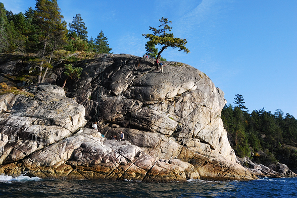
Looking the other direction. This is a popular place for climbers to practice. Look closely.


The park’s namesake.
I continued along in front of all the waterfront houses. Eventually these made way to the public access sea wall and beaches.
Approaching Ambleside
When done I pulled out and walked up to Marine Drive, and took the bus home. Not quite as exciting as some of my later adventures in the wilderness, but a day out in my kayak nonetheless!
Aug 31 to Sept 1 2012 — To Shearwater and Port Hardy

Bright sunshine in the morning

I headed over to Shearwater, and I planned to paddle back to the ferry terminal in the evening.

Times gone by

It seemed to take forever to get there. I was fighting the currents and wind. It’s all about expectations. I was expecting to just have a leisurely little hop over to Shearwater but it turned into a multi-hour slog about 1/3 as long as yesterday’s whole paddle. If I had expected a long paddle from the start, then I wouldn’t have been frustrated by the wind. Those Zen Buddhists are on to something.

I finally got into town and pulled up next to the harbour master with my boat roasting in the sun. I thought I might have to let some air out but it was OK.

I had lunch in the pub which was blaring some asinine television. Here we go again, culture shock. I then bought a book about the local wolves, written by Ian Mcallister, a local here who has been studying them for the last number of years, and who was instrumental in lobbying for the limited protection this area does enjoy, the so-called “Great Bear Rainforest”. The wolves are very interesting and it’s well worth the read. I have a soft spot for dogs so I love wolves. We used to have a wolf hybrid who looked very much like the one on the cover of the book. And it seems wolves have a soft spot for us too — they virtually never attack people.

As I sat in the sun, reading my book and looking out across the channel, I felt a real sense of accomplishment. I had gotten about 1/3 of the way to Haines; this was a major milestone for me and I had done it all on my own power (except of course, flying in and out between seasons). My pace had been way slower than I originally anticipated, but here I was! It’s about the journey, not the destination, as the saying goes.

It turns out the ferry also goes to Shearwater on its way south so I just waited there. I’ll see Bella Bella next year. This is the new ferry terminal.

Here comes my ride.

The boat didn’t leave Bella Bella until about 11 pm. It was jam packed full of people and they all threw down mattresses. The floor was wall to wall people. I pitched my tent out on the deck.

Morning.

Next year I hope to stay put in one place for a while somewhere up around Princess Royal Island and spend some time with wolves. I also want to see the white kermode bears.
Aug 30 2012 — Nice Weather into Bella Bella

You can see how high the tide came up, from the tideline to the right. Now just imagine me, standing in the dark, at midnight, with all my gear up on that green grassy / rocky area, cursing the tide. It’s kind of funny thinking back to it and I should have taken the opportunity to commune with nature under the moonlight. But all the frustrations from the last few days just came out. I felt much better by morning!

This is one of those times when I wish I had some time lapse video to show this starfish moving along that rock.

One of these anemones is not like the others… but they are of the same genus, Anthopleura.

It was the season when the kelp starts to fall apart and calls it quits for the year.


More calm skies. I lazily followed the shoreline up all day in the sunshine. What a nice way to end the trip. But, just like last year, the nice weather didn’t seem to arrive until the last day!

I think this is a solitary sandpiper. Definitely not on sand.

I was kicking myself for not checking the ferry schedule back at Hakai Beach Institute. I had no cell phone reception so I couldn’t get on the internet. At least I knew the ferry went north today. But would it head south tonight? Tomorrow? Three days from now? I wouldn’t know until I got into town unfortunately. I may have spent another night out if I had known, and I passed by an interesting crushed shell campsite that apparently has petroglyphs, because I didn’t want to miss the ferry.

This fishing boat was trawling and was just offshore from my campsite when I set off in the morning. They kept pace with me all day into Bella Bella.

As I was crossing a big bay the stormclouds brewed above me. I wasn’t in my drysuit. They soon burst and I raced to the other side to take shelter under this cliff and was almost totally out of the rain for about a half hour.

One of the last points before reaching Bella Bella.

Hah, and we were back to jumping salmon. The closer I got to town, the more frequent they became.

Nice! There is a hatchery on a creek right by the ferry terminal and they were all back for that. It seemed everyone and his dog was out in his boat trying to catch them but they didn’t seem to be biting much.

I came ashore at the ferry terminal and called my mom on the payphone to get the ferry schedule — tomorrow evening the red-eye came through. OK, that was settled. I wouldn’t fly back.

I wasn’t sure where to camp so I paddled another few kilometers into town. It was getting late and when I got to that public wharf it was really busy so I decided to head back to the ferry terminal and camp there.

I guess that’s why the tide was so high last night! The ferry terminal wasn’t the best place to camp because it’s at the end of one of the few roads on the island so anyone who has a car drives out there to see what’s going on, and they also came to see the salmon. So I had lots of cars drive by me, and a few people stopped to say hi. One lady warned me about a black bear in the area.

Aug 29 2012 — Holy Cow Rain!
Some rain overnight — what else is new…

There is another beach at this site that was an easier put-in.

I was ready for the weather, and it was still blowing from the south. I wasn’t complaining.
The winds and currents pushed me north pretty fast. I zoomed by Spider Island which apparently has an old WWII base, and a road leading across it. Midway along the island the rain started. I battened down the hatches and took advantage of the wind. A train of about 10 fishing speedboats from a lodge went by heading north. I was glad I wasn’t in one of those in this weather. They were probably thinking the same about me. Kind of ironic, eh?
The problem was what I would encounter after Spider Island, which is Superstition Point, a couple kilometers of exposed coastline facing the west. If you want to kayak northwards, you have to paddle it. It wouldn’t normally be a problem since yesterday I was in places more exposed than that, but this weather was really getting crazy. And the wind started coming from the west, which is definitely not the direction you want to be blown while going around that point.

I took refuge behind this rock, the last sheltered place before going out into open water. This is looking north and you can barely see Superstition Point on the right. I hung around here for about half an hour and eventually I couldn’t see Super Point anymore from all the rain. My boat was filling up with water. This is a problem because my drybags don’t really seal up. They provide protection from splashes but my electronics bag was placed sideways lying down on the floor in front of me, and there was about 2 inches of water in the bottom of my boat. I was worried this was going to flood my bags.
I decided that I had to come ashore. There is a portage around Superstition Point so I headed for that.

After paddling a small portion of exposed water and getting blown around pretty hard I entered the calm inlet leading to the portage. The rain continued and my boat turned into a bathtub.

I had to search around at the head of the inlet a little bit but I soon found the ribbon marking the trail.

I hiked the 100 meters five times for all my gear. I stayed in my drysuit and wore my sandals. I was a little worried I might poke a hole in my drysuit feet, but there wasn’t any gravel or anything else sharp to poke it. The trail was thick organic matter and peat moss. The forest was really beautiful old growth cedar. At one place a tree had fallen over the trail and I thought I should have used my saw to clear it a bit, but I was in no state to be doing that.

Finally, as I finished portaging my stuff over, the rain eased up. That was probably some of the most intense rain I have ever been in. It lasted for a good hour and a half and dumped about 3 or 4 inches, judging by the water in my boat. I climbed up a little bank on the right side to fill up my water bottles with all the water gushing out of the moss, no filtering required. This meadow was covered with goose crap.

Then the sun came out! And my gear was dry! I was perfectly dry in my drysuit! The extent of the water damage was the foggy lens you see in the above photo, which dried out pretty fast. I had lunch of peanut butter on mango, and energy bars. It seems I’m getting better at managing the rain. I still need to figure out how to get a quick and reliable way of making a front porch out of a tarp.

I was soon off again.

They don’t seem to mind the rain.
I followed the little inlet to the north and came out at Cultus Sound. The speedboats were there fishing. I crossed over and followed the coastline up to the north-east. I wanted to get to Latta Island where there was a campsite marked on my map. There are some really nice beaches in Cultus Sound but I wanted to plod on further while I could as this weather was causing me some worry. The only problem was that the map didn’t show many more campsites for a ways north so I’d have to commit to several more kilometers.
This area is pretty convoluted. I chose what I thought would be the best route heading north. Without my map and GPS I would have been lost. Yes, even me, Mr. Magnetic-Compass-in-the-Brain, would have gotten disoriented. I can’t imagine how the first explorers made sense of this place.
I went up Sans Peur Passage — that’s quite an interesting name. The current was behind me and I was making good time. But then midway down the channel I noticed quite a commotion ahead. It was the tides changing. I had no choice but to go through. It is a strange feeling being thrown left, right and center by strong currents, and trying to avoid whirlpools. The last time I experienced it this intense was way back in Big Bay in the Discovery Islands, and of course in Nakwakto Rapids at Belize Inlet. It’s a good display of the power in the ocean, to be able to move that much water so violently. All that power comes from the pull of the moon, and specifically the Earth’s rotation. But moving that much water around uses up energy and rotational momentum, so the result is that the planet has been rotating slower and slower over the ages, or in other words, the days are getting longer. They used to only be 23 hours. Eventually the moon and Earth will be locked tidally, and then there will be no more tides. Too bad for the rich intertidal life!

Shortly afterwards I passed another raging creek discharging gobs of foam into the sea.
As I made my way northwards the sun came out again and I had to undo my drysuit. I soon enough made it to Latta Island, the last island I would be landing on before turning up the channel to finish this year’s trip at Bella Bella. I searched around where the map said there was a campsite and couldn’t really find anything. I was a bit dismayed and decided I had no choice but to take the most suitable location, which had a little sandy beach way up at the top of the tideline. It wasn’t a very good spot, and it looked like it got flooded during high tide. Plus there was water seepage under the site from all the rain. Oh well, what else was I going to do.

I took advantage of the wind and sun to dry out my tent.

A black katy chiton. There is interesting intertidal life here. It doesn’t get bashed by the open ocean so much because the area is sheltered by Goose Island, a fairly large offshore island that I chose not to visit because doing so involves a long open crossing. It is supposed to be an interesting place though, with lots of bird life. And the northern tip is the site of the First Nations youth correction program, which involves banishing troubled youths to a few months of solitude in the wilderness. They seem to return as changed individuals — something we could learn from. Inmates leave regular prisons worse criminals than when they went in.

An interesting sand anemone that I haven’t yet ID’d.

I got another fire going which wasn’t easy due to both the wind and the lack of dry material to burn. I was running out of garbage to get it going.
At midnight I woke up to hear waves lapping by my head. Damn tide! It was flooding my tent! I had to move everything up onto the wet grass and rocks and stand there watching the tide in the moonlight. They say a watched pot never boils and I was not a happy camper to have to be spending half an hour in the middle of the night waiting for the tide to drop. Eventually it did. Luckily it wasn’t raining though. Note to future paddlers in this area: there is NO suitable campsite on the south side of Latta Island, regardless of what your map might say!

If you go to the dead center of this map, then look a little to the left, you will see a turquoise bay. Go check it out on Google Earth where you can zoom in more. I think they took the satellite image when the herring were spawning in that bay.
Aug 28 2012 — Disoriented in Hakai
It rained again overnight but the morning was dry. That barnacle log had shifted location with the tide. Their lives are totally dependent on where the weather takes them. At some point they’ll get thrown up high and then life will move on to something else.

There is a little creek tumbling into the water down a rocky waterfall just up the shore a bit. I stopped and filled up with water and because it was groundwater I didn’t filter it. I thought I’d try drying my shorts out in the weather on my mast.

But the rain was coming from behind. It hit me but didn’t last very long. That’s the way it seems to be out here, at least in summer. Everything blows through really fast so the rain is fairly intense but doesn’t last for long.

As I rounded the final point on Sterling Island before heading west out the channel back to the open ocean, I noticed wolf trails leading down to the water. They have a whole network across the island and will regularly run the routes looking for food, timed with the tides. It would be interesting to hike them, but you’d have to be prepared to crouch down a lot.
The currents turned in my direction as I headed west. I went out into the middle of the channel and was really moving. It soon spat me out into the ocean again and I crossed over Kildidt Sound to the Serpent Group of islets out in the middle of it. My map showed lots of campsites and other interesting things over at the Edna group of islands so that’s where I was heading. The wind started to pick up from the south and when I hit the Serpent Group I decided to cross on the windward side. That was a poor decision because I was getting hammered by both the southerly wind and the waves bouncing off the rocks. I thought maybe I’d see more sea otters on this side, which I did, but the weather precluded spending any time with them. I wanted to have lunch but there was nowhere to stop, it was too rough.

As I continued crossing to Kidney Island I went by a noisy gaggle of gulls making a fuss. I didn’t know what it was all about but in reviewing the photos it was another boil of sand lances.
The weather was really getting rough and I was paddling hard to get to shelter behind Kidney Island. I made it and just as I was rounding the final point into a calm sheltered bay a California seal lion followed me and got to within about 10 feet. Yikes, that is the one animal that could cause me some trouble if it decided to investigate and take a bite out of my boat. I went right up to the shore as quickly as possible. I pulled out my camera but of course he left just before I got it ready.
I took a break and had lunch here, and filmed some green anemones in the intertidal. The calmness was nice. But, there was no place to camp so I had to go back out. The southerly wind was blowing me onto Ronald Island so I had to fight the crosswind. I made it to a little channel between Ronald Island and a couple little islands to the west. I zoomed north down this.
This is where it got confusing. I had picked up a kayaking map of the Bella Bella area way back in Telegraph Cove two years ago. The guy at the shop said not to buy it, it is “worse than useless”. I figured, how could it be that bad? Well, the problem with maps is that they can indeed be worse than useless because if they are wrong, you can get yourself into trouble.
If I haven’t mentioned it before, I should say that I have a sixth sense when it comes to direction. I never get lost. But as I was approaching Triquet and the Edna Islands I just couldn’t reconcile the map with my GPS. I had to keep looking at it every few minutes and I couldn’t figure it out. Had I lost my sixth sense? No! The map was wrong! No wonder I was getting hammered by the wind and waves, as I was in the open ocean in the middle of a southerly storm!
This whole area is a bit confusing because there is apparently two groups of islands right beside each other, one called Edna Island and the other one Enda Island. They each have a campsite, and I wanted to go to the northern one. But their position in relation to Triquette Island (a larger one that protects them all from the open ocean) was way off on the map. I decided based on my GPS that I would head north down the channel to the east of the Edna Islands to get to my campsite, since that’s the way the wind was blowing. I couldn’t come into harm doing that.
So I made it across in the raging wind to take refuge behind another little islet.

It was here that I spotted this kelp crab in the kelp. Apparently the scuba diving around here is really good.

I moved out to go down the channel and then looked back to see this jewel of a protected beach on Triquette Island! What? It wasn’t on my map! Actually, yes it was, but I was in a different place than I thought I was.

I paddled back up from where you are looking, against the raging seas and currents. It took almost half an hour to get over from that point. It’s a really nice beach with a developed campsite. And the open ocean is right on the other side of the trees, behind where I’m taking this photo. I heard some cranes too; apparently there is a nice mudflat just to the west of here. However, the sand is very fine and given that it was only 3 pm I decided to move on. But as you can see, with the falling tide my boat got beached so I had to slide it back into the water on logs.

It didn’t take long to reach the campsite on Enda Island. My shorts didn’t dry out very well with all the rain. And you’d think I would have realized to take them down since I was getting bashed by the wind…

The site was fine sand again, oh well. There is quite a bit of garbage washed up here, and interestingly a bunch of large plastic pipes half buried in the sand.

Along with the garbage there is a lot of driftwood and I found a few dry pieces of cedar. I had brought along all the wood I chopped the previous night, which imparted a wonderful cedar smell to my bag, but it wouldn’t burn properly as it was too wet. Anyways, I managed to get a fire going long enough to cook dinner, which was pasta primavera. The rain was on and off, and it was starting to get on my nerves. The sun poked out for 5 minutes. At least there wasn’t any bugs.

Aug 27 2012 — Calvert Island to Sterling Island, and sea otters too.
It rained pretty hard through the night. And I learned that you really do need a mattress, especially if you’re sleeping on a slab of cold granite. It really sucks the heat out of you and the layer of air in your mattress keeps you warm. Plus my backback wasn’t exactly comfortable. But I made it through.

The sun came out by morning.

Calvert Island is more piney / boggy due to the nutrient-poor granitic soils.

I hiked back.

And came upon this little guy doing what frogs are supposed to do.

On the trail back from the beach I bumped into this deer that jumped into the wet bushes at the first open spot.


After checking email again and repacking I was ready to go. Then it started pouring.

I got all snug in my drysuit and set off. Then it stopped raining. This is looking east through the channel between Hecate and Calvert Islands, with the mainland in the distance across Fitz Hugh Sound.

I slowly made my way back up the channel heading north. I had a slight headwind and I wanted to be really careful with my shoulder so I just hugged the shoreline and crawled up.

I got to the last point before heading across Hakai Passage and ate some lunch in a kelp bed.
I made my way to the closest little islets with the wind pushing me out towards the open sea. As I crossed the channel I heard a humpback breathing over towards where I had the encounter the other day. I didn’t even bother looking. Imagine that, all humpacked out!
When I got to the islet I noticed some seals in the kelp that were moving strangely and sticking their heads quite a ways out of the water.

That ain’t no seal! That’s a sea otter! Finally — I’ve never seen them before in the wild!

This one was curious and got quite close. They aren’t so skittish like river otters.

There was a family of about five individuals that called this kelp bed home.

He went down and brought up a large California mussel. If you don’t know the story of sea otters, you should read up on it. They are a “keystone species“, or one that totally changes the nature of their ecosystem. They used to be plentiful in BC but the fur traders almost wiped them out. But they eat sea urchins. And sea urchins eat kelp… So with no otters around anymore, so went the kelp forests which are an important nursery for many species of fish. They’ve been moving south again from Alaska, and they are now down to at least Ucluelet on Vancouver Island. Along with this, the kelp beds are coming back.

Aww, look at the baybay! Elaine, look at the baybay!

After the weather started to get a bit worse I moved on and crossed over to Sterling Island where there was a campsite marked on my map. I was really fighting the current so I hit the shoreline as fast as possible after rounding this cormorant rock. It was 15 km to paddle today but it seemed longer.

Just let me sleep…

The rain came and I didn’t have my drysuit zipped up underneath my raincoat. My raincoat leaks in in the neck in heavy rain. Oh well. I was really happy with this campsite.

This is a great little protected bay / beach looking northwards.

And the wolves had been here.

Climbing over logs

Wolf sign

It is another crushed shell beach, another likely midden site. They are all over the place here. Great for throwing your tent down.

This beach has a large variety of berry species. Here is the ubiquitous huckleberry again.

This is thimbleberry which is related to salmonberry, but very sweet. The berries only last a couple days, if that.

Salal

Black currant

A different type of currant

Alaska blueberry


I never though barnacles made noise, but they do. If I touched this log they would all start seething en masse.

I got my stuff ready for dinner, and was dismayed to notice that I no longer had my windscreen for my stove. Bummer. I must have left it at the top of the hill last night, as I was racing around trying to stay away from the black flies and get in my tent ASAP. Oh well, it will just take a bit more fuel (methanol) to cook dinner from now on. I still had half a litre left, way more than I needed.
I went to start the stove and I opened the second of my 500 mL bottles of fuel. I had finished the first one. But it wouldn’t light no matter what I did. What was going on? Then it dawned on me that this wasn’t methanol, but water! Duh! Last year I filled this bottle up with fresh water for drinking when I had used up the methanol. I stored it for a year and then packed it up as methanol for this trip! Now what was I going to do? I had no more fuel. Was I going to starve??? Once the shock wore off I realized I’d have to get back to nature and cook my dinner the old fashioned way, on fires from now on. But all the wood was soaking wet! How was I going to have a fire?

Above the beach was this canoe, and a downed cedar tree.

Luckily I brought my axe / saw combo. And I’ve watched enough Survivorman to know how to get a fire going the hard way — with a lighter, dry paper, and kindling…

The fire wasn’t easy to get going or keep going with the wood being so wet, but I managed to keep it alive long enough to boil the water.

Usnea lichen hanging from trees.
I went down to the water to watch the soap opera drama of the tidepool sculpins and hermit crabs duking it out. There were thousands of them. It was really funny, and I should have gotten some video of it. Then, as I was standing still a grey shorebird landed pretty close to me. I didn’t want to move and scare it away. I just observed as it came within a few feet of me. It was a wandering tattler. Then it flew away.
As it approached dark the no-see-ums came out in full force and I had to retreat to my tent pretty quickly.

Aug 26 2012 — Hakai Beach Institute

Some unlucky sand fleas

Western sandpipers in the mud in the morning

I only had 4 km to get to the Beach Institute. My shoulder was still sore so I took it really slowly. I’ve dealt with tendonitis and similar conditions enough to know that you just can’t push it. You have to let it heal.

This place was a bit of an apparition. It is a bustling little university campus in the middle of the wilderness. It used to be a fishing lodge but the new owner decided to do something different with it and joined up with the local First Nations to turn it into an environmental science field station.


They have an impressive solar farm and battery bank (and big diesel generator). This is one of those times however when you wonder how much energy was required to build the renewable energy system versus how much it will ultimately produce. That isn’t a criticism, since in remote locations you need to have local energy supply, but more of a recognition of a problem we will encounter everywhere in the future as we transition to renewables by necessity because fossil fuels run out.

The perfectly manicured grounds just seemed bizarre. They are very open to visitors here, offering free wifi and fresh water. And I could plug in my battery chargers. But they don’t provide food or have anything for sale. I sat at the info building at the top of the ramp and went on my computer. Lots of boaters came up to check it out, and I had some good conversations about their trips. One couple hadn’t set foot on solid ground for a few weeks. I ended up being the information person for visitors for a couple hours as I found out the answers to the questions I was wondering, that other boaters were also asking when they arrived. Kind of funny, I fit the part, and had to tell people that I didn’t actually work there.

I hiked across to West Beach. I had hoped to see some wolves here, but there were just too many people around. One of the guys said that there is another beach further up that may have them, it’s called “wolf beach”. But I didn’t feel like putting in the effort to bushwhack to it.

Instead I was going to hike up to the lookout and camp there. It’s amazing how I could barely fit my stuff for one night in my backpack. The rest of my stuff I left at the Institute. I really need to focus on slimming down my gear.

Thick west coast mud

Gnarly

That’s where I was going.

Very recent trail building

There’s a nice panoramic view up here. It isn’t very high, Google Earth says only 50 m but I think it’s higher than that.

Looking north to where I’d be kayaking tomorrow.

The black flies were really bad up here. I didn’t cook my dinner, I just ate some energy bars and looked for a tent site which was really hard to find. I ended up on a rounded granite outcrop that wouldn’t flood if it rained. I went in my tent ASAP and listened to the weather report which was calling for rain. I was pretty exposed up here at the top of this hill. I didn’t bring my mattress from lack of space so I slept on my empty backpack.

Aug 25 2012 — Across Fitz Hugh Sound to Hecate Island
The weather was beautiful in the morning — sunny and calm with only a few fog banks down south. I had really wanted to cross over to Hakai and head up that way; the route up Fitz Hugh past Namu didn’t look as interesting. Luckily, the weather made the decision for me.
The dogs had been with me all night, except for the times when they went nuts and ran off into the bushes. For some reason I got used to them barking and slept through most of it; probably because they were doing it to protect me. I offered them some peanut butter covered mango for breakfast but only the older guy accepted it.
I avoided the keeper since I don’t think he even wanted me to say goodbye. The younger of the dogs sat at the top of the road watching me pack up while the older one was zonked out. I sadly waved goodbye and set off, once again, into the unknown.
I had 9 km to cross since Koeye is located at about the widest part of Fitz Hugh Sound. There were a few boats around so I’d be OK. A couple hours should be more than enough time to cross before the afternoon winds picked up. Or so I thought…

A phalarope of some sort. I passed lots of seabirds; you notice a lot more life out on the water when it’s calm. I came upon one little guy sleeping while floating. He had tucked his beak into his feathers and was snoozing away. Just as I got my camera out he woke up and took off. This one above was less wary of me, having seen me coming.

Interesting cloud patterns on the water that day.

The water changed from deep clear blue to more like green pea soup as I passed through algae blooms. Believe it or not, but this is the stuff that powers our economies. Oil comes from plankton that settled out onto the floor of ancient seas hundreds of millions of years ago. Remember that when some economist or oil industry apologist tries to convince you that we should accept environmental degradation for the greater purpose of powering economic growth based on fossil fuel extraction. Anyone who tells you that ecology is subservient to economics is either lying or totally delusional. They’ve got it completely backwards. And when you see images of the industrial landscapes across Alberta with all the upgraders and refineries processing the oil sands, and you’re told that, “it’s the price of progress”, No! Don’t believe it! Progress does not come from burning up irreplaceable energy reserves at a rate 200,000 times greater than deposition rates! Remember that no matter how hard they try to hype that technology up, those industries aren’t “producing” petroleum, or anything else for that matter; all they’re doing is harvesting and burning that green stuff you see in the above photo. Without this oceanic equivalent of … pond scum, the Alberta oil companies are nothing! The Alberta economy is quite literally subservient to pond scum (not that there’s anything wrong with pond scum). We are still completely dependent on ecology for our survival.
As I neared to within a couple kilometers of the opposite shore (Nalau Island) I heard a humpback somewhere in the vicinity of Hakai Channel. I made my way over. And it seems the humpbacks made their way over to me…
It was a pod of about five or so and they got pretty close to me, within a whale’s length. For about half an hour I hung around with them as they ambled about in the channel. I was a little worried when they got too close but everything was fine. I didn’t take photos since the light wasn’t the greatest and I had photos from the previous day, plus they weren’t feeding. I pulled out my video camera and unfortunately I zoomed in for most of the footage which was a bad idea since it got so shaky. But I got a few half decent segments.

Then they moved away up north.

They started feeding as a group…
It was hard to get any decent shots with them a few kilometers away now but they still certainly made their presence known. I’d be paddling along and then I’d hear a huge crash, like blasting going off. I’d look back to see five humpbacks slamming into the water and making a commotion. But by the time I got my camera ready it was always too late. The noise echoed all around the Sound. Everyone could hear it.
Then one of them let out a grunt. Holy cow, I’ve read that you can hear a humpback underwater half way around the world and I can believe it. He was a couple kilometers away but it sounded like he was right beside me. I nearly jumped out of the boat. Interestingly, it is thought that noise pollution in the oceans may be interfering with blue whales‘ ability to find each other over long distances and hampering their recovery.
BC had a whaling station up until 1968, located near Port Hardy. They cleaned out most of the humpbacks from BC but thankfully they are now returning.

The luxury yacht that was enjoying the show along with me.

I wanted to go check out the Hakai Beach Institute down on Calvert Island, so I crossed over Hakai Channel. I was in the influence of the open ocean now and there were big swells with huge wavelengths. They were crashing hard on the rocks but I was able to get in really close safely. I took some interesting video showing the size of the waves.

After taking lunch in a semi-protected kelp bed I continued south down the channel. This is Hecate Island in all its glory.

My shoulder was getting really sore so I was taking it easy. I slowly followed the shoreline down, keeping an eye out for campsites. There didn’t seem to be a whole lot of opportunities.
I looked on my GPS and thought there might be a good spot around the next corner. But when I rounded it I was presented with a busy fishing lodge. Oh well, I continued on a tiny bit further and found a nice bay with a great little cobble beach.

I had been thinking about how I could carry more water with me, as I would be going through Hakai which consists of many little islands without much water available. After the scary situation in the Broughtons two years ago I wanted to make sure I had spare capacity. Well, like magic, I found this brand new, never-opened water bottle on the beach… among the only garbage to be found. It probably fell off a fishing boat at the lodge. It wasn’t very big, but an odd occurrence. Kind of weird, and this happened back at Shelter Bay too. When I wished for a jug of fresh water, it just washed up on the beach the next morning!


A pair of noisy sandhill cranes flew overhead in the direction you’re looking. And I caught glimpses of some sort of little weasel racing along the edge of the vegetation. I pondered that even though when I arrive at new places I can get a bit lonely before I get to know them, and that no matter how sterilized and impersonal a map may make a place seem, it is inevitably someone’s or some animal’s home. Every place is unique and special. Was this my home too?
I took advantage of the evening sun and managed to dry out most of my gear. It’s amazing how two hours of sunshine can make such a difference.

This is a good camping spot as the tide didn’t flood the whole beach, leaving enough space for my tent. In a storm surge it might flood though. And there is a creek nearby.

August 24 2012 — Spending the Day in the Koeye Estuary
Tracks left in the sand revealed that my big furry friend had returned this morning, but only to check the tideline and he didn’t come closer than about 20 feet. It seems they’re not out to get us, they just want to check the tideline like they always have.

The weather was decent.

The dogs had been barking most of the night and they came over to say hi while I loaded up. I felt like I should give something back. I tried offering a peanut butter covered date but it wasn’t a hit.

I headed up the river to the estuary and went by this gull that seemed to follow me. It got quite close.

The tide was way down. And the water was brown due to all the tannin runoff from the rain. The salmon were gone. Overnight, the seasons had changed.

It was the season of plenty with berries everywhere and salmon in the rivers.

There was a noisy pair of eagles near here.

Misty, mossy mountains

Ahh, there must be something going on upriver…

I passed a family of river otters and there was a funny noise coming from a half submerged tree on the bank. It took a while to find the source which was a baby otter and mother. It was super cute but I couldn’t get a shot of it in time.

As the meadow came into view I saw a black blob moving along the shore.

The river was getting shallow and I had to get out and start walking up. These headless salmon are from wolves. They only eat the heads, some think it’s due to parasites in the meat they want to avoid. We have an advantage because we can cook our food.

The place was noisy too with some Canada Geese.


It wasn’t long before I saw the wolves on the opposite bank, near where a branch tributary of the main river was joining and forcing the salmon to go through shallow water. The bear that was wandering down the shore joined them.

It turns out I was pretty lucky to see the wolves. They normally only come out at night and they avoid people. Considering that there there’s usually a person or two coming up to the estuary every day for various reasons, I’m surprised I saw them. The timing of the low tide helped with that. I was pretty far away but the clicking of my camera sent them off. Damn you Nikon!!! Time for a new body. Maybe the D400 when it comes out.

I went further up to a main junction where there were some salmon making their way up the shallows. They are really hard to get close to, I’m impressed the animals can catch them. I contemplated going up the side channel a bit to see what was there but the water was too shallow. Good thing too, because a few minutes later I looked up that channel to see a mother and cub come wander around. Too bad there was a tree in the way!

I never did actually get a good shot of the two together. Then they ambled off again.


The meadow seems to consist of sticky organic mud matted together with grass roots.

The forest here is very beautiful. It is old growth and has never been logged. There is something magical about being in it.

Biological oils from all the productivity going on here were getting caught up in the downed logs. These licorice ferns were making one last dash for life.

I spent over half a day up the estuary, and the time went by really fast. As I was heading back out with the tide the bear was back at the salmon spot, but the tide was high so he wasn’t catching any salmon.

I find that my kayak is somewhat limiting in some respects. I’d like to be able to ditch a lot of my gear sometimes and just go up the river for a few days and camp out. I would love to camp in the forest overlooking this feeding spot and get up with the break of dawn to see the wolves. That way I wouldn’t disturb them, I could remain in the forest. But what would I do with my stuff and food? Without a sailboat or something similar to store my food and excess gear in out at the bay, I can’t do that. Oh well, the kayak provides other advantages.


OK, last shot.


Everything is covered with growth here.

I came back to that friendly gull. He was sitting on some rocks and wasn’t at all afraid of me. I put my paddle up to him and he climbed on board. I thought I could have a new pet. But then I realized he might be sick, who knows, maybe with avian flu or something. So I put him back.

As I rounded the bend into the bay I looked out to the ocean and saw the big triangular mouth of a humpback shooting out of the water right at the entrance to the bay. I couldn’t believe how much life there is here. I went out and tied up to the kelp but he had left.

Evening light looking up the Koeye Valley. Yet another fantastic day in another fantastic place along our coast.
I went up to the construction site because there was apparently a keeper there minding the place with everyone gone back to Bella Bella. I wanted to camp up there because I’d had enough with grizzlies wandering around my tent. The keeper was the quiet foreman from before and he said I could camp there, but he wanted to be left alone. He came here to have his privacy. I obliged and set up camp on the outskirts. I tried to dry out a lot of my gear in the last rays of sunshine, and then I downloaded photos to my computer.
The dogs kept me company. They have a great life here. It might end up being cut short though because the wolves will probably get them at some point, with them chasing bears way up the valley. I guess that’s their life, short but exciting. I’ve found that I feel the most alive when I’m in the moment, when decisions you make could mean the difference between life and death, and you have to rely on yourself and your own capabilities. That’s what many of us urbanites tend to yearn for, to escape the drudgery of the 9 to 5 where everything is predetermined and “safe”. But is it really any more dangerous out here than in a city? I can walk down the sidewalk downtown and at any point just take two wrong steps and get run over by a truck. What’s the difference? It’s just that out here there’s no one to save you (at least immediately). In the city we get a sense of security from all the people everywhere.
It seems like everything comes together to make the Koeye a special place. The barrier islands open up right across the Sound, just enough to let the big open ocean waves through. The bay is a little sandy jewel hidden behind a headland. There is a lake up the river that I didn’t get a chance to see unfortunately, even though there is a trail leading up to it (I couldn’t find it).
In my very short time here I sensed a different vibe, the First Nations presence seems to be more “in tune with nature”. I know that sounds cliche but I get a different feeling here than in mainstream society. Even our official parks are an extension of mainstream society, at least their administration, as we tend to visit them to “consume” the wilderness as an antidote to our urban lives. I guess I’m no different in what I’m doing.
The white man outposts along the coast seem to be just extensions of the city with people flying in from Toronto to get in a weekend of fishing where they bag as many fish as possible from their noisy powerful speedboats that can get them from A to B in mere minutes. Their fish are prepared for them by the staff, and then they fly back out. All the while, satellite radio and TV keeps everyone entertained with the creature comforts of home. They never actually have to leave the city; it comes with them. I guess it’s tempting for me to develop a holier-than-thou attitude, and a little unfair, as I make my living from consuming the natural world just like everyone else does.
These aren’t simple issues because this area has to “produce” economically in order for our politicians to leave it semi-wild. If the fishing lodges didn’t bring in the money and if the people on the cruise boats didn’t want to see beautiful vistas of unbroken forests then the whole coast would have been logged instead. Get away from the more frequently visited places like the Inside Passage, and it pretty much all has been, except what was lucky enough to be locked up in parks.
And most people can’t get in a kayak for two weeks to experience the coast; the cruise boats are their only opportunity. Are they being any more “consumptive” than I am? Hell, I bring pre-packaged plastic satchets of ready-to-go food to power my journey. Where did those come from? Most of my gear is made of plastic. Plastic comes from oil. And I flew in on a noisy gas-guzzling plane.
It wouldn’t be a nice place here with thousands of kayakers everywhere experiencing it up close and personally, and the grizzly bears up the Koeye River sure wouldn’t appreciate it either. So I hope that people can experience being immersed in the wild through my accounts here, without actually having to go through all the motions themselves. Then maybe my impact on the wildlife will be somewhat mitigated.
August 23 2012 — Day Off in the Rain at Koeye
It rained pretty hard overnight. And the water came up to within about 5 feet of the tent. And I slept with my head pointing downslope so I could keep an eye on what was going on outside. But this position was causing me a lot of muscle ache in my abdomen for some reason.
It wasn’t the greatest sleep with the rain on and off. When it wasn’t raining I had the front fly open so I could see out. But then when the rain came I had to close it up which meant I had no idea what was going on outside.
In the morning I dozed around in bed and then went back to sleep for a while. I was just coming to when for some reason I felt the need to look out the front which luckily I had unfurled when I first woke up.

And there, standing about 4 feet away from me (more like, above me), was a grizzly bear.
Hmm. Was this a dream? I was still half asleep. After about a second I realized it wasn’t a dream and “You have got to be $#&!ing kidding me!” was the first thought that went through my head, and then without time to even contemplate what I would do, out came a loud, “HOLY SHIT!”
That was enough to send him on his way down the beach. He was just checking the morning tideline for any goodies that may have washed up last night. I had my food bags sitting outside the front of my tent and that’s what he was interested in. I do not believe in tying your food up a tree unless you have a really good opportunity to do it properly. It is likely that the bear would just climb the tree anyways if he wants the food; apparently it’s an old wive’s tale that grizzlies can’t climb trees. If I had done that here I wouldn’t have even noticed since the noise from the waves would have probably overpowered the noise of the bear eating my food. And then we would have had a problem bear on our hands that correlates people with food. Instead, I’ll defend my food. If he had really wanted my bag he would have grabbed it and run away, and since I usually tie it off onto everything else that would have woken me up. Then I would have chased after him with bear spray to retrieve it — problem solved.

Thankfully he was just investigating and then continued poking around down the beach.

He casually made his way around the bay, past the longhouse to the lodge construction site.
I was wondering what kind of entertainment I was going to be getting from across the bay. Soon bear bangers were set off from the boats and the big bear dogs started going wild. He high tailed it into the bush and the dogs were in hot pursuit, barking like mad. This lasted for quite a while and I could hear their progress way back into the bush up towards the river, behind where I was camped.
I dozed off some more and then almost hit the roof when out of the blue something crashed my tent. I let out a yell louder than I ever have (I don’t know what the sailboat overnighting in the bay 100 m from me was thinking about all this). The problem arises if something crashes your tent before you have the chance to 1) get your spray ready, and 2) unzip your tent, in which case 3) you’re kind of screwed. Thankfully, I don’t think most animals would just come out of the blue and suddenly crash a tent without hanging around and making some investigatory pokes first. In the case of a cougar, you are totally safe in your tent.

Anyways, a few seconds later I saw that it was the bear dogs on their way back, stopping by to say hello. They tried to get in my tent but I wasn’t having that.

This is the young guy.

The older, more wise of the two.

For most of the day they hung out with me. They knew their job — to protect people from bears, and they did it well. They slept most of the day, as they seem to be barking throughout the night at every noise or scent they pick up.

Not a huge bear — probably an adolescent just getting into mischief.

It rained on and off for most of the day and I had no initiative to do anything. But lying in this downward position all day was really causing me a lot of muscle ache. Stretching out didn’t help.
A younger guy from the work group walked down and I had a talk with him. He had been volunteering here for a couple weeks as a carpenter after being at the Hakai Beach Institute (see a few posts in the future). He was heading back to Bella Bella tomorrow, and then back to Victoria for school. It turns out he is friends with people I know from the Ucluelet Aquarium! Small world.

The gulls making a fuss over something.

Poking around the forest behind my tent.


The place with all the action. It’s kind of interesting, the kids’ camp is located almost a kilometer away from the main lodge, up the river above another sandy beach. That seems to be where the bears go through as there are lots of tracks there. But, there doesn’t appear to be any problems.
Aug 22 2012 — Blair Island to Koeye
The wind picked up a bit by morning but the sun was poking through. It was a pretty difficult put-in as the tide was completely out, way below the rocks I camped on. I set up and video-recorded the fun of me loading my kayak. But the dessicant strip in the housing was full and the GoPro camera fogged up when the sun hit it.

I headed north across the bay.

Every piece of “dry” land here above the tide line is covered with thick vegetation.

Looking west across to Calvert Island with Addenbroke and Sweeper Islands in the foreground.

Yes, the sea she was angry that day! But only if you were heading south. Or over at Calvert Island where there was showers. I was laughing where I was!

The narrow channel between Sweeper and Addenbroke Island

Looking north

Looking east up Fish Egg Inlet. Just more of my big playground…

I love the patterns of old growth cedar.

Solar powered light station

With such a nice tailwind I had some lunch as I drifted north. Peanut butter, Persian dates and dried mangoes.
It was a pretty uneventful day as I headed up the coast. I had tailwinds and tailcurrents all day.

The Koeye River empties into the chuck before that mountain. It’s well hidden in a small bay.

As I made the final approach I turned crosswind to get around the headland protecting Koeye Bay. The big winds had created some decent sized waves, plus there are open ocean waves pounding this shore as well. They were all bouncing off the rocky shoreline creating a few tense moments as I made my way across. I made it though and here I was rounding the final point.

The Koeye watershed is a fairly recent conservancy and is sacred to the Heiltsuk First Nation. They had a lodge here which burned down last year. They are rebuilding it now.

I went up to say hi. There was a Nature Conservancy guy here hiking the trails with a group of First Nations grizzly researchers from Bella Bella. They have set up barbed wires along the bear trails to snag tufts of hair which they then send off for DNA analysis. They were up the trails today. If only I had been here a day earlier, I could have gone with them! I said that I’d camp on the beach on the opposite side and the work crew foreman said that was fine, although there has been a bear wandering around some mornings. He wasn’t overly talkative so after a few minutes talking about things I headed down to go look up the river.

Norwegian Camp is an old mine just up the river from the bay.

The tide was still rising and I rode it into the estuary. It is an interesting place because there is a kilometer of river protecting the estuary which is a ways back from the ocean.

The river was low since there hadn’t been much rain lately. The water was warm and crystal clear and I could see salmon zooming around underneath me. They were pinks waiting for the rains. They were jumping all around me. I couldn’t stop laughing, it was so funny, there were thousands of them. It’s not easy to get a picture of a jumping salmon but here it is.

Looking up the estuary

Rain was starting in the mountains.

It soon moved down to the estuary so I decided to take refuge under a tree and wait for the tide to turn so I could ride it back out.

Just as I was getting back to the bay it started to pour. I set up my tarp and tent in the rain with the fine beach sand getting everywhere.

The gulls taking a break for the evening.

Then the sun came out! I shoulda waited and set up my tent in the dry!

And of course a rainbow.

Aug 21 2012 — North From Penrose
The next morning brought lots of little fishing speedboats right offshore. I guess this is a good spot for salmon.

The tide was way down, exposing the impressive extent of the shell deposits.

The upper tide line being encroached by forest was also thick shell deposits. Another reason this is a great camping beach is that there is a very sheltered tent site above the beach amongst the cedars, out of the weather.

This was a small pebble that was completely encircled by live barnacles. I guess it spends its life rolling in the surf, otherwise one of those faces would be clear.

A nice easy put-in in the tropical-like waters. There was nothing tropical about the temperature of the water though — 12 degrees in the middle of August! That’s how warm it gets here! El Nino years would be quite a bit warmer, however, and that’s when more southerly species come up.

Purple and orange ochre stars, and green surf anemones

I came upon this gaggle of surfbirds (that’s actually their name). They showed very little fear and I got to within less than 10 feet. The currents were fast and in my direction so I tied off to some kelp and started clicking away. I was there for a good half hour.

Chickens of the sea, pecking around the surf line and seaweeds

This guy liked eyeing me up.

Looking across to Calvert Island

I continued on north for a little while with the currents behind me and made the almost 3 km crossing to the mainland.
As I reached the other side I heard a humpback and went over to investigate. It was a lone whale feeding using bubble nets.

There’s something fishy going on here, I can tell… It’s easy to get a shot because you just point the camera to the bubbles and … wait for whale.

There he is! Taking a huge gulp of presumably herring.


He was moving around a bit and I kept my distance of about 50 to 100 m. I just hung out near the shore of the little island, repositioning myself every few minutes.


Barnacles


You can see the baleen here.

Yum! Herring!

I hung out for about an hour, then moved on after the activity died down a bit. I needed to make some miles, but on the other hand, I came here to see humpbacks feeding, so what more was I going to see?

I planned to camp up near Addenbroke Island (the one with the lighthouse) and I was basically out of water. I needed to get it from the mainland somewhere as the island would not likely have any. The GPS showed a little creek entering at one point so I went ashore in the difficult waves to fill up from this picturesque little gully.

Maidenhair ferns
It had been another fantastic day with cooperative winds and currents. I started to scout out potential campsites but the coastline was pretty rocky. Addenbroke looked even more rocky and steep so I instead elected (there was only one of me so the election was a landslide) to investigate the sheltered waters of Blair Island.

I rounded the bend into the bay at Blair Island and found a little islet with some fairly flat rocks. The time was 5 pm and I hadn’t seen any other suitable camping spot for a while, and there didn’t appear to be much further on either, so I called it a day. Back to sleeping on angular rock outcroppings…

It’s a nice little spot and there appears to be a place nearby on the main part of the island that might have a small pebble beach that doesn’t get flooded, plus entry and exit would be easier there. Not ideal, but if you really need a campsite it will work.

Sept 29-30, 2012 — Circumnavigating Cloudburst Mountain, Squamish
I’m reminded why I love bike touring so much. I’ve long been a fan of Lee Lau‘s mountain biking / skiing adventures. So I decided that it was time to get off my butt and do something with my weekend, since it had already been 4 weeks since I finished my latest kayak adventure… (I’ll get back to writing that trip up too, I’m a bit bogged down right now).
A guy at work had recommended High Falls Creek up the Squamish Valley so I pulled up Google Earth, did some Google searching, and put together plans for an overnight mountain biking trip. I was going to circumnavigate Cloudburst Mountain by riding up the gravel road to the pass at Tricouni, then descend down the other side to the Cheakamus Valley, and then climb back up over to the Squamish Valley, where I left my car.
After a lazy Saturday morning I barely got out of the house before noon. I had been fighting a weird lung infection for a few weeks and it felt a bit better, but not really. I wasn’t sure what to expect of my body but I wasn’t going to waste a perfectly good weekend.
I drove through all the tacky “development” along the Sea to Sky Highway until finally getting away from that madness when I turned off into the Squamish Valley which thankfully hasn’t changed at all over the years.

I pulled up beside the golf carts to plug in at Camp Squamish. Is that what my car is? A glorified golf cart?

A rooster

WTH?

A little intimidated by what I was in for, I set off. I had 10 km of flat valley bottom riding before the spur road climbed the sidehill.

Nice pastoral scenery along the valley bottom. It has been very dry, with only one rainstorm in the last 3 months.
Shortly afterwards the pavement ended and I left the private lands and entered “Tree Farm License 38” which, despite being logged out, is still publicly owned Crown Land. There was a First Nations settlement agreement recently however which transferred title of a large amount of land over to a group that will hopefully better manage the resources than our culture has.

The mighty Squamish

A hydro power plant on a tributary of the Squamish. The water comes all the way down those penstocks from above. The amount of power produced is proportional to the pressure (height of water), so you can see they get lots of power from that.
Soon after the power plant is the trail for High Falls. Unfortunately it is way too steep for a bike so I had to ride up the gravel road that hikers who hike up the falls hike back down to return to their cars.

The views got better and better as I climbed.

And climb I did… Thankfully, my lungs and body performed admirably.

Looking Up the Squamish Valley
I passed three groups of hikers heading back down. They were all impressed with me riding my bike up, not seeming to give themselves credit for hiking up the falls themselves. It’s harder walking…

As I rounded the valley the road levelled off a bit. That’s Cloudburst Mountain poking through the clouds.

Crossing High Falls Creek in the high valley above the waterfalls.

Up and up some more

Misty mountains
After a few hours of hard climbing I reached 820 meters elevation, up from 50 m where I started. This was near the end of the road.

The fireweed had finished for the season, going to seed. This is very near the end of the road, at least as far as I went on it.

Since logging roads go up to the pass from both sides, the Cheakamus and Squamish valleys, and almost but not quite meet, being only a kilometer apart, my intuition and Google Earth skills convinced me that there must be a way between the two valleys. My intuition proved correct, as this quad trail led from the cutblock through the old growth forest to the other side.
I set up my GoPro video camera on my chest for the trail ride but unfortunately it was aimed too low and the footage was ruined.

Yeah! So stoked that everything worked out as planned. Here I had just emerged on the other side, in the Cheakamus drainage now. I had good cell phone reception so I called my mom.

My mechanical steed

From here I could see across Cheakamus to Garibaldi Park and Black Tusk. I have hiked up there many times, but never actually climbed the Tusk itself out of a fear of heights (and large falling rocks from climbers above). That’s the microwave tower to the left, which may have be providing the cell signal, I’m not sure.

Wider panorama of Black Tusk and The Barrier

This is The Barrier. It is a crumbling cliff face that holds back the quite large Garibaldi Lake. I imagine some geologists have probably studied it, but I would not want to be anywhere near that valley in a big earthquake.
I turned back up the road going up to Tricouni to get away from the cooler and noisy valley bottom creek so I could set up camp. I found a great spot just up the hill.

Evening light


What every man wants to see outside his tent.

Always pleasant surprises when camping
I pulled out my iPhone and surfed the internet. Internet in the wilderness! I was so content. Everything had worked out perfectly. My bike worked great, and my body was fine. My worst booboo was from when my D7000 camera that was strapped around by back came flying to the front while going down a steep section and whacked my funny bone. Man that hurt!

Poking my head out the tent before sunset


Ready to go in the morn

Good to see the bears are getting their phytonutrient antioxidants.

Looking back up to Cloudburst Mountain as I descended Chance Main to Cheakamus

Some recent logging

Some valuable yellow cypress left behind. I don’t get it. Each of these logs is probably worth $10,000 but they were just sitting there.

Slimy mushrooms growing out of the road

Lucille Lake


Crossing the Cheakamus River. It’s quite a bit smaller than the Squamish.

Yet another view of Cloudburst Mountain, partially obscured by clouds.

Cheakamus Canyon

Unfortunately there doesn’t seem to be a way of avoiding a few kilometers of Sea to Sky Highway for this circuit. At least all that “development” brought good bike lanes.

Tantalus Range, on the west side of the Squamish Valley (right where I parked my car)

There is a trail that follows the Cheakamus Canyon and spits out on the highway. It was here that I left the highway and descended into the canyon. It is an old cattle drive trail from the 1850’s. I also rode up it many years ago in the Cheakamus Challenge mountain bike race.

This is why the trail goes up to the highway and ends — an impassable canyon, and the railroad crosses the river. I am unsure if there is a trail going north on the west side of the canyon, following the railroad. It would be nice if there is since that means the highway section could be avoided.

It’s a little eroded in places.

Nicely upgraded with pea gravel.

Starvation Lake

Nicely upgraded … yeah right! More like shale hell! I guess they hadn’t finished their work and there were lots of sections like this with unridable loose shale thrown down. I hope they’re going to fill that in with some fine material, otherwise they’ve ruined the trail! I had to stop and tighten my racks at one point as they were rattling around. For this kind of offroad riding (which is basically all I want to do) I would like to try to get set up more like a bikeback, which doesn’t use racks and panniers, instead strapping sacks and bags strategically around on the bike frame. Less stuff to weigh you down and rattle off. Less space too, which forces you to take less stuff.

There is a pedestrian bridge across Cheakamus River.

From the bridge there is a trail that goes up to meet a road leading to Butterfly Lake at the top of the hill. This road starts from right where I parked my car. So my plan was to go up this trail and ride down the road on the other side to complete the circuit.

Once away from the part of the trail that serves the private residences along the river, the trail seemed disused. At the first switchback it turned steep. And washed out. Brutal.

The washed out brutal steepness continued for quite a while. I was hoofing my bike up for about an hour and a half. I had only brought 500 mL of water and there are no creeks. I ran out. I was getting worried. There were a few places with views across Cheakamus to brighten my spirits.


As I was beginning to get a really dry mouth and an uncooperative body I summitted the pass into the Squamish Valley. Whew! After some equally brutal, unridable descent I met up with the well groomed road.

Within a minute I reached Pilchuk Lake. What a wonderful relief that was! As I was getting my water filter set up an SUV came by. They were residents up at Butterfly Lake. This road is private but they were friendly and I don’t think they minded that I was there when I told them where I had come from. They told me that the trail I hauled my bike up used to be their road in! Wow, I guess they only used quads before…

Nice scenery riding down towards the Squamish


Almost there

My only damage, from getting whacked by my pedal. I also lost my front mudguard.
Well I had made it. I was so glad how it all worked out, and it was only like 3:30 in the afternoon! All the distances seemed to go by so fast! I think that has to do with spending so much time in my kayak lately where I’m thankful if I can maintain walking speed. Total distance: 52 km.

Heading home

The daytime heating had created an inflow wind at Squamish and the windsurfers and saiboats were out taking advantage of it.
Well that was a fantastic trip. I have been out of commission for a few years due to my physiotherapist-inflicted leg injuries, limping for 2 years and on crutches for 6 months, and I was wondering if I’d ever get back up to speed. One day, years ago, I had done a big adventure where I drove up to the Black Tusk microwave tower, left my bike there, drove down to the Garibaldi Parking lot, then hiked up to the Tusk and rode back down to my car, all in the same day. Well this adventure was along those lines so I guess I haven’t lost it! I’m back baby!
As usual I got some videos which I’ll post later when I get it sorted out…

