July 30 — To the End of Belize Inlet and the Bushwhack
I woke up to sunshine and calm winds! And lots of bugs. Along with my usual morning routine including collecting salal berries for my oatmeal I took advantage of the sun to set up my solar panel on a big stump to charge my GoPro camera. I also assessed all of my food supplies – two weeks’ worth, not including any fish I catch. This should be enough to get me to Rivers Inlet where apparently there is at least one floating general store in a bay somewhere, catering to the summer boating crowd. My map sucked, so I didn’t know exactly where it was but I’d figure it out.
This spot is beautiful, especially in the sunlight. It was reflecting off the water onto the cedar trees on the nearby shore and making interesting patterns, below a vibrant moon in a blue sky.


A little bit of morning marine layer

All my food


Because of the Narrows, there is very little garbage on the shores here. This was some bling left by birds. Probably a stolen lunch sandwich from some forestry operations.

I also noticed more of these hundreds of tiny fish which I had seen before a few times in the last few days. They were only in the inlet, this side of the Narrows. They were about a centimeter long and schooled by the thousands. I got out my fish net and scooped some out and saw that they were actually swimming mysid shrimp. If I cared to I could make a meal out of them, some stew or soup. Just scoop until I had enough.

The little shrimp were all around my kayak here.

That’s the floating house I would paddle by.

Logging operations a few years later. Alder grows on the disturbed soils of the roads.

Fresh logging with some soil disturbance

A variety of age classes. Above is old growth. Below this is relatively recent cutting and in the foreground is maturing second growth forest.
I still needed water so I’d hug the northwest shore as I paddled to see if any of the indentations on my map actually had water. I got as far as the northwest point of the inlet and at this point there is a valley with a creek. However, I had to hike a ways up the creek to get away from the salt water. I took video of this whole affair. I strapped the camera to my head and my audio recorder to my wrist and started hiking up the mud flat. I had to cross the creek once and I was thigh deep, walking across slippery boulders. If I fell I could destroy my audio recorder. Luckily I didn’t.
I felt uneasy walking up this creek because it is perfect bear habitat. I noted how much the vegetation reminded me of my home forests, the Seymour Valley in North Vancouver (not to be confused with the other nearby Seymour Inlet and River up here, they are totally different). I love exploring those verdant riverside forests in North Van but I also know that there are no grizzlies there; there would likely be some here.
I got to a point which obviously had fresh water so I filled up my new found water bottle from Shelter Bay. The grass beside this spot was flattened from something large, presumably sleeping. I returned to my kayak and filtered it, then went for another water run. That went by fine as well.

I had to hike into the trees a little farther than you can see here.
Then I decided to get some underwater video footage of the shrimp. They were in the brackish flow of the estuary by the hundreds of thousands. They seemed to be feeding off the bits of stuff flowing down the creek.

It’s interesting how different the marine life is in this inlet compared with the open ocean just outside the Narrows. That mostly has to do with salinity, especially in winter when huge volumes of rain and meltwater flood through the inlet and do not have a chance to flush well with the full strength sea water outside. It would be interesting to find out what the salinity is here in winter. As an interesting aside, there is an observation that all the natural fluids in the world have roughly the same proportions of elements. Rain water, fresh water, and sea water, they all have roughly the same composition of minerals. What is interesting is that the fluids of our bodies, like our blood plasma, have a very similar composition to sea water, with the exception of elements like nitrogen and phosphorus, but at only half the strength. This is why you can’t drink sea water. We have the same internal salinity as fish but they can drink sea water because they use energy to pump the excess salt out. This consistency is thought to be a relic of our primordeal origins as fish in the oceans; our bodies have maintained he same internal chemistry ever since.
I also noticed the lack of marine mammals in here; I can’t imagine any whales or dolphins coming through the Narrows. There were, however, plentiful seals because they are everywhere.

With that finished I continued on towards a logging camp a kilometer to the east. But as I was leaving I had divebombing displays from those gulls, which I think are mew gulls. They have the most beautiful, haunting, lonely calls. This one didn’t let up and got more aggressive as I got towards the floating house. I don’t know what it does when people are at this place. Maybe it is guarding the house for its owners. It probably had a nest around there somewhere. It got really aggressive and was bombing me repeatedly only a few feet above my head. I took photos of it but it was difficult to get good shots as it came in close because panning was hard. It went up over my head rather than from one side to the next.


Giving me the evil eye
The wind was picking up from the south so I was getting hit with some waves from the side as I went along. There was a large log boom perimeter protecting a calm area which is where the logs would be stored before being towed out. This was bouncing waves back at me. When I cleared this it got a little calmer. I crossed over to the south side of the inlet which was now going east, since that was in the lee of the wind.
There were more gulls here so I recorded their sounds and I’ll put them up when I finish writing the blog and figure out how to do it.

A normal gull on the big log with the smaller mew gull down below


Old logging near the head of the inlet


I think this clearing has to do with helicopter logging up above. I think they drop the logs here before towing them out.


I now had a long straight stretch to the final bend to the left which would be the end of my time on the water for a while. The paddling was uneventful in the sunshine with a nice tailwind. The mountains were getting higher. There was snow on some of them. At the end of a large island I crossed over to the north side before the inlet turned north. I spotted a murrelet nearby up against the shore and tried to get photos of it. It didn’t seem too scared of me but by the time I got my camera out it was gone.
I noticed on the other side of the inlet a picturesque waterfall cascading straight into the water, so I could have filled up my water there rather than at the previous creek. This creek must be fed from high elevation snowmelt since it was going pretty good. I wasn’t sure if I would have water at my pullout since the map showed a small stream but I didn’t know if it would be running.
I finally rounded the final corner and saw my adversary for the next few days. Or should I be more optimistic and call it my “friend”? I felt a bit of a lump in my throat. I just didn’t know how the next few days would go. The location was beautiful and sunny, and nice and warm with a light breeze.

Rounding the final corner. That is my pass up there. I say “mine” because it may not have ever been traversed before, I don’t know.
I also noticed some very large impassable cliffs which were not noted on Google Earth or my topo map. That’s OK though because I was going up the valley to the pass at the base of those cliffs. I still had to get to over 300 m elevation though.
There was an abandoned barge at the very head of the inlet near where I would enter the forest. The grassy spot beside the creek would be the best entry point. I was glad to see that the forest was no longer hypermaritime, which is an almost impenetrable tangle of thick brush. This forest was again more like what I was used to around Vancouver – a high closed canopy with relatively sparse understory vegetation. This is of course all relative. It is still very dense.


For some reason I wanted to make some headway today so rather than camping on the barge, I decided that it would be to dangerous to pull my kayak up against the rusty metal and instead packed up all my stuff to see how far I could get in the bush before dark. I had a couple hours left. The tide was coming in but I got it all sorted out and off I went.


I would do the portage in five loads, with one backpack full of little things that never leave the pack. All the remaining large items would be carried in my kayak backpack. I would fill and empty the pack with each run. I would go about 30 meters per run and then dump my stuff and come back for the next load. This would be five loads in total.
It doesn’t sound too bad and I convinced myself of that. It is only about 2.5 km across to Long Lake where I would then go down to Wycleese Lagoon and then exit into Smith Inlet, thereby bypassing Cape Caution. Well, when you consider that I had to return 4 times to get the additional loads, we can do some math and add it all up: 2.5 km times 5 for the loaded runs, plus 2.5 km times 4 for the return runs. That equals 22.5 km. And that is over rough terrain.
The first run crossed the creek and went up to a little bench above the creek. This continued on for a hundred meters or so. Then I crossed another little dry muddy creek and after this the incline started. It went up for another 100 meters, but it got steeper. I was taking comfort in that it was actually very reminiscent of the Grouse Grind in Vancouver which I used to do regularly and get very good times on. That is a 700 meter vertical climb up Grouse Mountain above Vancouver which is 2.9 km long I believe. It is basically just a huge staircase.
Based on that history I should have no problem with this bushwhack. The problem was that I was still recovering from severe patellar degeneration and tendonitis in my right leg from the nerve damage and all the damage the physiotherapist and doctors inflicted on me. And I was only in running shoes. I didn’t have space for more sturdy footwear.
Anyways, this day was a success. I did about four or five runs and near the top of this steep hill, I set up camp in a relatively flat spot. I went to sleep amidst the symphony of mosquitoes buzzing only inches from my head outside the mesh, wondering what the next few days would bring.

The forest is very similar to what you see on the Grouse Grind. Just substitute Sitka Spruce for Douglas-fir and everything else is the same.

July 29 — Running Nakwakto Rapids and up Belize Inlet
Before I got out of bed a tug boat came by towing a log boom out through the narrows. You have to time the tides right to pull something like that through the narrows! This is a working forestry area with lots of logging so I expect to have boats around. The old growth cedar and cypress is very valuable wood.
There were productive salal bushes all over this island so I augmented my morning oatmeal with berries and of course sugar. I am able to do this frequently since there are so many salal berries along this coast at this time of year.


Launching was a bit more difficult that anticipated because the rocks were slippery but I got away and rounded the corner of the island while fighting the currents. I would go as far as I could and then wait for the currents to die down before going through the narrows. Since it was going against me there was no chance of the current carrying me away past a point of no return and sucking me into the abyss.
I didn’t get very far until I reached raging white water. This really is an amazing spectacle. The water was raging by and very loud. It was like a huge whitewater river. There was a clear line separating the raging current from the kelpy little cove I was hiding in. The water was calm where I was tied up on some kelp. There was a small back eddy, and only 15 feet away, that back eddy met up with the 15 knot torrent (who knows).
Low tide was at 10 a.m. so I would just hang out here until the water slowed enough to be safe. Unfortunately it didn’t. For over an hour I sat there watching a log circling endlessly in the eddies, snoozing, and taking photos.
I realized that there is a lag between the tides and the currents. The current continues to gush out even after the ocean tide has reached its minimum and begins to rise again. This is because there are over 150 km of inlets behind Nakwakto Narrows, the two main ones being Belize to the north and Seymour to the south. They both generally head eastwards, filling in the channels created by parallelogram shaped mountain ranges. If it wasn’t for this 300 m wide channel, the whole thing would just be a very large lake.
So all the tidal water volume is fed and drained by a 300 m wide narrows. What happens is that the water flow through the narrows can’t keep up with the tide levels in the ocean outside. So even though the tide is low in the ocean, the inlets still haven’t finished draining and water continues to gush out until the tide rises enough to equal the level of the inlets. Then you get a slack tide and after this the current switches and the cycle repeats but on a high tide. Because of this, I am expecting the tides to have a narrower range once inside the narrows. I’m sure there’s some partial differential equation in there somewhere… I imagine that under certain conditions, and with big river runoff, the narrows could get crazy.
Eventually after lunch the currents died down enough and I crossed the channel to a larger bay on the other side which looked calm enough to make some headway. I went from cove to cove and at one point the current was just too fast so I had to retreat back five meters to hang out in the kelp only two meters away from the fast water, and wait a while. I took photos of Tremble Island, which is a rock sticking out of the middle of the rapids. Its trees are hanging with signs from people brave enough to land and climb on the island. I don’t know how long slack tide lasts here. Probably not long. I saw the sign from the Vancouver Aquarium. They went there a few years ago on an expedition up the coast. There were a few ducks on the rocks of the island and that would be an interesting place to camp. Maybe some day I’ll do it. I wonder if it would be a first.


The raging water was only a few meters to my right.


Looking east up Seymour Inlet


Looking northwest up Belize Inlet
There is interesting marine life in the narrows, with the strong currents. There are extensive beds of giant barnacles but I won’t be checking that out. You can eat barnacles by the way. They are crustaceans like crabs and apparently taste like them.
I got through the rapids and after another work boat went by I immediately crossed Seymour Inlet to the other side because I didn’t want to get sucked back through the narrows by crossing near its mouth.


There are tons of burrowing sea cucumbers in the inlet. These are a different species than the California sea cucumber I caught last night. They aren’t as mobile and keep most of their bodies in crevices, with their fluffy tentacles extended to catch plankton from the water. They have beautiful colours ranging from purple to orange. I got some nice footage of them as I moved along in my boat.

Burrowing sea cucumbers
I didn’t waste any time heading up Belize Inlet, which goes northwest until doing a big U-turn at the corner of the parallelogram and turning eastwards. Seymour inlet goes east right from the narrows. It’s all semantics though. They are all just inlets.
The wind was against me but the currents were with me as I worked my way up the inlet. Because the currents were with me, this meant that the back eddies in the coves were against me, so in order to take advantage of the currents, I had to stay away from shore for much of the time. But this put me out in the wind. The two tended to balance out and I made decent progress.
At one point I saw some weasel-type critter in the trees right at the water’s edge. It took off quickly. It was fairly large but I don’t know my mustelids well enough to be able to ID it.

A very strange tideline. I don’t know why it is so sharp. I have seen this a few times so far.

A logging access dock

I reached the 270 degree turn at Mignon Point. I was actually not far from the big beach at Burnette Bay near Cape Caution. It is just a few kilometers over the land to the west. But with my kayak I do not want to risk that open ocean. I would not be able to land safely in big surf and there is nowhere to take refuge if needed. This is a shame because apparently it is a beautiful beach. Instead I am taking the inland route northwards. It will include a 3 km long bushwhack. I wonder if it’s ever been done before. I may be doing a first!
I began heading due east and the expanse of Belize Inlet lay before me, a dead straight shot into the mountains that went on for miles and miles. I soon crossed over to the north side and saw a rocky reef off in the distance. There were some sticks sticking up and I wondered if those were put there by someone to warn boaters of the rocks. But when I got to it I saw that the sticks were from a large log that had gotten stuck on the rock.

Looking east up Belize Inlet after Mignon Point


The marine life changed markedly in this inlet, compared with the open ocean. There were a lot fewer birds, but more loons. Also, mussels had returned. They had been absent from most of the open ocean shores I had been following previously. For some reason they seem to prefer the inlets which receive some fresh water dilution. I am not sure why. It might have something to do with their main predator, the ochre star.
I was getting pretty lonely in the empty vastness of this huge country. I had seen no boats since leaving the narrows. I passed by a few logging operation docks. I was starting to miss the open ocean now. I finally got to the beginnings of Mereworth Sound, which is the inlet leading off to the northeast from Belize Inlet. Right around here I saw some seals on some rocks which lifted my spirits a bit. Also, a speedboat passed by on the other side of the inlet, and a large ministry forest ranger boat went around the corner. I was wondering how much territory that boat must cover, and what it was doing up here.


Just through this channel I came upon…
I passed a floating logging camp which looked like an interesting place, with cedar shacks and a patriotic BC flag. No one seemed to be home though.


. I was heading for some little islands a few km further on, but I needed some water. I crossed over to the other side to where it appeared that there was a small river entering the inlet but when I got over it appeared to be way up some marshy estuary in the trees and I didn’t want to risk a bear encounter so I instead just went back across to the islands.

Scenery to the east


There is apparently a creek there.

I didn’t want to go look for it.

My island for the night


The skies had cleared up and the setting was stunning. The mountain across the inlet was cloaked in beautiful old growth cedar forest and these islands were really interesting. I was feeling very lonely and homesick at this point and the beautiful location helped temper that but I had been on my trip for a month and a half now and I always get homesick at that time, no matter where I am. Plus I had only spoken to one person for almost two weeks, since leaving Telegraph Cove. So I had curry again.


Looking east from my island. What a view!

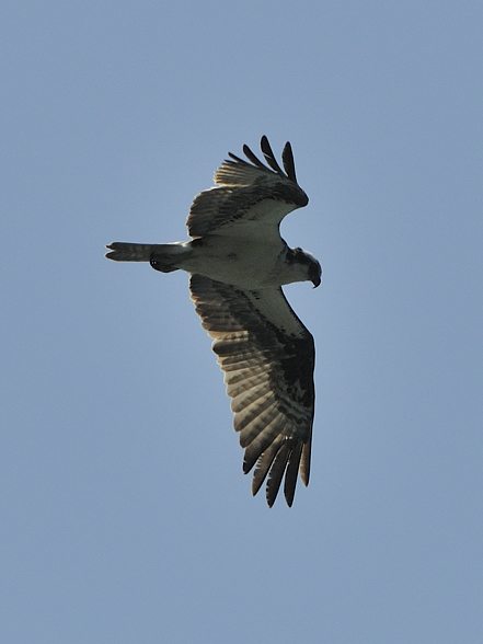
An osprey was watching me from the trees. As soon as I pointed my lens at it it took off.

July 28 — Shelter Bay to Nakwakto Narrows
I packed up early this morning to get out ASAP. But I had to make a final trip to the “creek” for water and I was freaked out crouching down there. At least I had this new water jug which meant I didn’t need my drybag for water anymore.

Looking west


Between the trees there is the next cove over where the cougar was sharpening his claws.

The creek feeds right behind the big rock on the left. The cougar was throwing around little logs right around there.
Launching was nice ‘n easy on this low tide and the sand went all the way down. This is apparently a good clamming area.


I had to backtrack south a bit to get around the islands forming the outer wall of Shelter Bay because at low tide they aren’t islands.
I sure was glad to put Shelter Bay behind me. It seemed like a mirage when I first arrived but this whole cougar business freaked me out. It was an interesting experience to be on the giving end of the food chain. Whether or not I was on the menu I don’t know. I guess the answer to that depends on whether I was crouched or standing tall at the time.
It’s interesting how your opinion of a place can be so swayed by your own personal emotions at the time. Shelter Bay is a beautiful spot. And if I had ben there with a few other people so that the cougar situation wasn’t so scary then it would have been OK. But the fact that it was so deserted, but with so much evidence of people being there only a short time before, gave out such a creepy vibe for me. Plus, the fog just hanging around a few hundred meters to the west added to the tension. I think we need to try to do that more — analyze things more objectively without our own personal emotions skewing things.
I decided to try to camp on islands as often as possible fromnow on. I got a good night’s sleep the other night on the island near Blunden Harbour, without having to worry about bears.
The fog was thick as I went along the coastline and it was fogging up my glasses every few minutes. I was in my drysuit but it was so calm I didn’t need it. The Macrocystis beds became more prevalent.

Macrocystis kelp bed just outside Shelter Bay

Stuck in the kelp
I came upon the Southgate group of small islands and went throught the channel separating one from the mainland. There were oystercatchers around but I didn’t record their sounds. I want to do this.
I had my GoPro camera and the audio recorder going as I was paddling along and then I cut off the video but kept the audio on as I paddled. As I came to the end of the first island, through the fog I suddenly heard a HUGE breath over the bay near the next island. Holy cow that was a big whale! I could see the breath in the air. There were two humpbacks, a mother and a calf. They were working their way along the coast of the other island, heading away from me. Wow, you get an appreciation for the volume in that lung when you hear it in the stillness of the fog.
Interestingly, I was heading towards a small rock covered in birds at the time, including cormorants, when I heard the whales. But when I heard them I totally changed my focus from the birds to the whales, even as I drifted towards the bird rock. They didn’t seem to care and I could get closer than if I was focusing on the birds, even if I was trying to pretend to ignore them. I think they are smarter than we give them credit for. Maybe they were watching the whales too.
I turned on the video camera and got some footage of me watching the whales but with the fog it was only footage of me. But I did get some nice audio of the whales breathing. I was a little scared by all of this. What if one came up underneath me in the kelp without realizing it? I wanted to go closer to the whales but besides this being illegal I believe, I was too scared. They went their way to the east and I crossed the bay and continued north, with the video camera going all the way. The fog was still thick.

Thick fog


As I passed by the last of the islands the waves picked up a bit but it was still really foggy. I had a couple more km of relatively exposed coastline to go before I got to Schooner Channel, which is the waterway that leads beside Bramham Island up to Nakwakto Narrows and Seymour Inlet. This went by uneventfully. When I got to the head of the channel the fog began to lift a bit and I could see across to Vancouver Island and the boats in the Strait. There was also a pleasure craft across the channel to the north, nearby another humpback. There were also a few porpoises around.
I tied off onto some kelp beside a little island near the entrance of Schooner Channel and had some peanut butter and dates and somehow my map ended up in the water but I retrieved it. The currents were going against me so I hung out here for a little while and pondered this being the last time I would see the open seas again for a while since I was now going inland.

There was a humpback over there.
I instead went north up the channel to the east of Schooner Channel. My crude map showed that it might get through at the other end but after 10 minutes I decided not to risk it based on the still water so I turned around and went back up Schooner Channel, against the current by hopping from one bay to the next. An aluminum work boat went by, coming out of the inlet.

Looking up Schooner Channel

Last look back towards Vancouver Island

Near the end of the channel I saw an interesting little outcrop totally covered in bushes. Apparently this is an old aboriginal village site. It is situated in a strategic location, right in the middle of all the action only a km away from the narrows.
There was also an otter taunting me here so I followed that guy for a while around another island. I think this is also the entrance to Cougar Inlet, which goes in a few km to the east. I don’t think I’ll go there!

I then crossed westwards over to the island across the channel which looked to be a good camping site. It was almost in the narrows but still out of view.
It turned out that it was a good camping site. There was a protected little haul out area which looked to be not too difficult with a low tide but I would not know until the morning. There were open mossy rocks where I could pitch my tent. However, the currents really ripped through here so I had to be careful. I wouldn’t want to get sucked into the narrows.

I got set up and decided to go fishing. This was an ideal rockfish spot. There were angular steep rocks going into deep water with lots of current – ideal. I first caught a California sea cucumber and decided to keep it because you can eat it. However, the muscles are very small and turned out to be rubbery and not too tasty. Then I caught a small copper rockfish and threw it back. It wasn’t long before I caught a keeper and I decided to get another. I could have easily caught dozens of these guys but two was enough.
This spot also had a great flat rocky part down below, just above the water. I could clean the fish there and just wash the guts back into the water so bears wouldn’t be an issue. But they’d have to swim across the swift channel to get here so I doubt they’d even bother.


My new jacknife was coming in handy. Sorry guy! I have to eat! I’ll grant you the respect of looking in your eyes before I eat you though.


That is the digestive tract which they expell under stress. All that is left is those five small longitudinal muscles.
I cooked up the fish with all my spices which was good. The wind was a little strong but it died down nicely after dark. Tomorrow I was going to got through the narrows and the low tide was around 10 a.m. so I had lots of time to sort myself out.

The narrows are just a little ways around that corner to the left.


The water would really move at times by here.


Tiger lily going to seed


July 27 — Day Off in Shelter Bay
I didn’t sleep well last night with all the waves and presumably a cougar walking around. Once the light returned I felt safer though and got some more zzzz’s. The tide was down at this point which also helped.
Around 9 a.m. I heard some logs being thrown around the beach in the next cove over where the creek was. I assumed it was a bear.
I was feeling quite frightened with all this animal activity around me. Wolves, I’d like to hang around with. Black bears aren’t too much of a worry. Grizzlies are a cause for concern. But cougars normally take off. When they hang around humans that is a bit frightening. If you are with a few people you can watch out for each other. But while alone you can’t. You are vulnerable when you crouch down because you appear small. You need to stand tall and act aggressively. At least I was safe in my tent but I couldn’t stay there all day. I went for a stroll up the trail from the campsite into the forest, which was pretty but there was bear scat everywhere. I returned and started a fire on the beach to make me feel better. I made it in the lee created by a couple of big logs. But then they caught fire after a while and I had to bucket up sea water to put it out.
I also attended to some more chores today. I sewed up my frayed sleeping bag using dental floss. That is the best thing to use when you are camping. It is very strong and you use it for your teeth anyways.
I also wanted another water bottle and just as requested, the high tide left a 1 gallon water jug on the beach for me. I tasted the water inside and it was a little salty so I dumped it out.
I also found a piece of half inch plastic pipe half buried in the sand. I cut this to length and heated it up in the fire. Then I bent it into the shape of my head and attached my headlamp to it. Now I had a head brace for my video camera! It was still a little shaky but better than before.
Also, the previous people had left a jackknife on a log after slicing up an apple (they left the little plastic sticker which I burned). This was a nice knife and I’ll have a use for that I’m sure. Also nearby was a model 4X4 in the sand which I pulled out. This place is full of surprises! I got all the provisions I needed!


I made a trip to the creek and I had to hike up through downed logs about 15 meters to a point where it was dripping off some rocks. There was just a little trickle. I had to wait several minutes for all my containers to fill up and I felt vulnerable because I was crouched in a ravine. I had my bear spray ready.
Also on this little water trip I saw the log that got thrown around before. It wasn’t too big but I could see the claw marks in the sand. For some reason I assumed it was a bear but now thinking back, obviously it was a cougar sharpening his claws on the log just like our cats do. The paw prints weren’t very large and the ones that were from swiping had big claw marks.

July 26 — Getting to Shelter Bay before the Winds Picked Up
As I presumed yesterday afternoon, the rocks were indeed covered in slippery intertidal life all the way down to the water. By 7 a.m. I was ready to go and started packing my stuff down to the water. I was able to negotiate the upper rocks without too much difficulty but then they became very slippery a little bit further down. This was potentially very dangerous since if I slipped and wedged my leg I could easily break a leg or twist an ankle.

Stunning coastal architecture
I put on my running shoes since my sandals were not going to cut it. I tried making a pathway out of medium sized beach logs taken from further up the beach. I would string these along in a line and try to walk on them whenever possible. This also presented danger if they were to shift while I walked on them. I would also try to walk on the occasional patch of barnacles because these provided great traction, but they were spotty.
One by one, I humped each of my loads and my boat down about 8 meters at a time. Eventually as I passed the very slippery mid level rocks they became a bit more negotiable, but not because they were less slippery, but instead because they were covered in so much sea weed that this held my feet in place.

I would have taken more interest in the rich intertidal life that was giving me such headaches but if I was going to make any decent time today I had to get moving soon; I couldn’t dilly dally or wait four hours for the tide to rise. I did take a picture of a blood star which feeds by absorbing the dissolved organic molecules and bits of stuff it comes across from the pea soup in which it lives, this emerald sea which is deep green from all the nutrients brought here from upwelling currents. These nutrients feed the vast kelp beds which have been a dominant part of the ecosystem on my trip so far.

Finally, after about an hour, I got all my stuff down the twenty meters to the water and started to load my boat. But I couldn’t load it in the water because it got too deep around the rocks to easily walk around. I also didn’t want to get my shoes more wet. So instead I put the boat on my logs and loaded it there. I would slide and launch it off the logs. After one good soaker, I was ready to go.
My plan to slide my boat along the logs forgot to consider the skeg at the back end of the boat. So I had to lift up the heavy back end of the boat and then push. I did this a few times, repositioning the logs each time, and then it was in the water. Finally, I was off! But that has been the most physically difficult thing I have done on my trip so far.

I continued on up the coast in the typical calm winds and fog. After about five kilometers I passed by the official opening to Blunden Harbour. So I didn’t get as far yesterday as I had hoped I would. This opening is a tiny little waterway that cuts through the outer peninsula of Blunden Harbour, and is only accessible at high tide. It was dry now.

The first of three fish farms I would pass today


A little ways past this I went through a fairly narrow channel separating an island, and I had to really fight hard to get through the currents. I hopped from one sheltered spot to the next and got through. I then immediately started to feel more of the swell from the open ocean. I also at that point, not coincidentally, saw my first patch of Macrocystis kelp, which is different from the more common Nereocystis bull kelp that has been ever present on the entire length of my journey so far. Macrocystis needs the influence of the open ocean – the water movement and the more constant salinity. That is what it’s getting here. I have seen bits of it washed up previously, but not the actual plants themselves.
I also encountered another fish farm pen here, no doubt positioned to take advantage of the swift currents to carry away all the wastes. Other than the odd fish farm, there really is nothing in the way of human life up here. There is of course lots of logging just onshore but no permanent habitation.
The waves generally got larger as I went along. I crossed a large bay and the bird life was quite impressive. There were auklets everywhere. This is what marine biodiversity could and should be.

Rhinoceros auklets
I had a GPS coordinate for Shelter Bay, my destination for the day. I had no map of this particular stretch of coastline. Yes, that’s right, I had no map, except an extremely crude cartoon drawing from a tourism brochure which basically shows this coast as a straight line. I didn’t think I’d need one since it is fairly straight forward – you just keep going along the coast. So I didn’t print one off. That’s what I was doing though – following the coast. But there were more bays and islands than I wasexpecting and this was throwing me off a bit. I was counting down the distance to Shelter Bay and it was still a good 5 km away.
I came to another set of islands and noticed quite a few sport fishing boats around, presumably across from Port Hardy. The currents were pushing really strong against me. The place had a different feel; it suddenly seemed more exposed and raw. I fought my way up through some channels and then I saw another little cheater channel off to the side of one. I pushed through the current and was then immediately in calm water. I could see that this led into some more rough water. When I got out of this I was fighting the wind, waves, and currents and I made a dash across to the next little island.


After this I had to cross another open bay to get to the mainland again. This proved to be quite rough, actually very rough. It was north-facing, exposed to the open water, and the bathymetry of the bay was making some very large swells, like about two meters, which is large for my boat. I would have put on the video but it was too rough. I fought my way across and kept going up the coast past the large breaking waves. This was rough water. I was getting concerned. I was praying that the winds would not pick up because I could be in trouble. I also wished I had put on my drysuit today. I was glued to my GPS. How could it be so far to Shelter Bay? The meters were creeping by and I cursed my slow progress. I looked to the trees to confirm that I was moving but it seemed to take ages.


Finally I came to a sheltered bay and the winds were picking up. I saw that the peninsula forming the outer edge of the main bay went a little further up, but I really did not want to round that point since it would surely be very rough! Hopefully this little bay led to a shortcut into the main bay and it did. I also smelled rancid fish. As I entered the main bay I passed by an empty floating farm pen. My GPS said that Shelter Bay was still a kilometer away. I had to cross this north facing bay to get to it, and the winds were really picking up now. I started to cross, with the gloomy and muted greys of the ocean fog to the left contrasting the clearing skies to the right, inland just above the trees with brilliant sunshine and pastel greens. I could even see the mountains through which I would be paddling over the next few days.

The cheater channel through to the larger bay


Gloomy fog to the west

That is the point I was glad I didn’t have to round
Once across the bay I took a rest in the lee of a little island and then pushed the final leg upwind to Shelter Bay. It was like a mirage, with its glistening sand beach shining in the sun.

Glorious sunshine to the east

That’s the Shelter Bay beach!
I landed and hiked my stuff up to the nice campsite. It is really nice here with flat soft tent sites and a large rope for a bear cache.


I also noticed a sign warning of a cougar in the area. And after setting up my tent I noticed a tuft of tan coloured hair beside it. Some parks people had recently been here doing some maintenance and putting up the sign, so I assumed they had brought a dog with them. Sure….


That’s dog hair beside my tent. Sure….
Tonight’s dinner was another round of Mediterranean Pasta with those brown chunks of meat-like things. I normally have a two-servings portion along with additional rice or plain pasta to add volume. I also add some spices like cayenne pepper, onions, garlic powder, or oregano and basil. I cook it until it is pasty, then add cold water which not only cools it down quickly, but turns it into stew. I like this and it fills me up well. But I am always hungry regardless. Today I thought I would up the ante a bit and make up four servings instead because I had worked so hard. I could eat more of it later.
So I cooked this up but the problem was that it filled the pot, so afterwards I couldn’t add the cold water. This meant it had a thick consistency and the sauce was very strong with all the spices I added. This was too much and I quickly lost my appetite. I just couldn’t eat more than half of it. I felt bloated for the rest of the evening and the only responsible thing to do was waste a good portion of the dinner by throwing it in the ocean because otherwise it would attract bears. Oh well, one dinner wasted; live and learn. Also, I checked the ingredients on the pasta and those brown things were actually some kind of processed soy product. They tasted good though normally, just not tonight.
Now somehow I had managed to convince myself that the tuft of hair beside my tent was from a dog. Obviously it was from a cougar. But I was still paranoid about animals crashing my tent at night so I did something I had been wanting to for a while. The problem is if a bear crashes the tent I won’t be able to get out in time because I wouldn’t be able to pull the zippers in all the caffuffle. So I got some pink ribbon from the little creek in the next cove over, which the parks people had used to mark its location for campers to access water (I took it off the ground), and then attached this to the one zipper that I should pull down vertically in an emergency. Then I would position this in a location where I could easily grab it in an instant if necessary. I would also sleep with my knife handy in case I needed it to cut the mesh. Of course I slept with my bear spray.
That night I did not sleep well. I was bloated and at midnight the tide came up. With the higher tide the waves were not broken by the bay floor and they were large and noisy. These waves were bouncing off the far end of the bay. When they hit the logs at the top of the beach they make strange sounds that can sound surprisingly similar to a bear growling. Just listen to them nonstop only 20 feet from your tent for four hours at midnight…
I wasn’t worried about cougars while in my tent though because they wouldn’t bother me there, but it would present no barrier to a bear.

July 25 — Bear on the Beach
I quickly packed up in the morning and started hiking my stuff down to the sandy flats way out at the head of the cove.


There was a six inch deep pool separated from the open water by a sandbar. I set up my kayak there and then had to drag it 30 meters through shallow water with the skeg dragging to where it was deep enough to get in.

I had to fight a few breaking waves on the way out but it wasn’t too bad. I got out and was again on my way. The sky was gloomy and the winds were light.

I went along the coastline for a while without much happening. It was just steady paddling. It’s good that I decided to call it quits at my last campsite because there weren’t any suitable locations further up along this coastline. I could see the beginnings of Blunden Harbour which was to be my destination for the day.

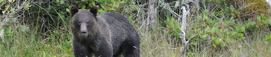
As I was approaching the first island which would provide some shelter, there was a sailboat coming my way. I thought I might talk to them, but then I noticed something large and black on the rocky beach – it was a bear!
I immediately headed over and got out my camera. By the time I got to it, it was in a different spot, right by the water, flipping up hundred pound rocks as if they were nothing, and eating the shore crabs underneath. I took several photographs and the sailboat came over too. I decided to see how close I could get and when I got about 30 feet away he decided he’d had enough and turned away. Then I backed off and continued on my way.


The winds were starting to pick up now and I headed to the little island across the bay which would provide some shelter. Along the way I saw another kayaker coming my way. We waved and I headed over. He was in an inflatable kayak! We rafted together to talk a bit. His name was Mikhail and he had just paddled across from Port Hardy. He’d had a difficult time in the winds in his inflatable kayak. He had just spent the night on a grassy patch in Blunden Harbour and was heading down the coast to finish his trip in Telegraph Cove. He said there were a lot of bear signs around his campsite and he did not sleep well!

Where you are looking is where he came from yesterday

By the time we separated we had drifted a ways back and I had to fight really hard to get to the island I was originally heading for. I made it and did not see any obvious nice campsite except a rocky beach on the south west lee side. I went up through the kelp beds to the northern end and tried to cross over to the next island but it was almost impossible in this wind. It would have taken me a half hour of full out exertion to just go a half kilometer.

Thinking about what to do while taking a break in the sheltered kelp beds
So I went back to the first rocky beach I saw and checked it out. It was actually a half decent spot. The rocks were large and smooth, since this spot obviously gets pounded during south-easterlies. They also had few barnacles on them so I waited around in the kelp for a half hour until the tide rose above the few barnacles there were. I then landed and got on shore without too much difficulty. I knew I was going to have problems in the morning though because the tide would be out and I could see that the rocks extended way down and they were covered with slippery intertidal life. But I had no choice.


I was in the lee where I was standing. Around that log sticking in the air, the wind was howling.

It was still fairly early, not much after lunch time, so I would have lots of time today to relax a bit. This was also a nice spot because I assumed there would be no bears on this small island. However, as suspected, there were no suitable tent sites because the whole beach was either large cobble or logs. Right above the logs was thick salal bush. So I figured I’d have to make my own tent site.

Lotsa logs

Thankfully, I soon found a piece of plywood washed up, which would be perfect!

I set it up at the very western edge of the beach, which happened to be the calmest. But only 20 feet away the wind was howling. It was blowing down the west wide of the island which is exposed to the open water. But the trees shelter this one little spot.


As the tide came in it also created a nice bathtub against the bedrock at the edge of the beach. I love this spot!


Plus, there was a hummingbird that kept buzzing me. I hoped to get a photo but I didn’t manage to succeed. I also found a washed up old fishing lure container. These were home-made flies, and most were too far gone but a few were usable.

I had a nice snooze for an hour. I also charged more of my batteries but to charge my GoPro batteries you have to plug the power straight into the camera; there is no external battery charger. This probably works fine on a desk, but out here it is a pain. Of course I caught the cord while walking around and pulled the camera across the rocks. This scratched the lens! I was not happy, but the damage seemed to be minimal.
I also tried fishing off the steep rocks on the western side, only 30 feet from my tent. I got a few casts in but then my lure got stuck in the barnacles under the rock. I just left it there and planned to return later when the tide was out to see if I could loosen it. Sometimes I get really frustrated with fishing.
I again mustered the courage to try to fix my water filter. The glue I used was indeed strong so the only way I could re-separate the two pieces would be to cut them. So I got out my file on my Leatherman and started cutting around the shaft where it attaches to the handle bracket.

Once done I was ready to go. I again set up on a big log. I glued it back together and held it for a few seconds. Then I realized that I hadn’t put it through the red piece! Duh! I quickly pulled it apart and then shoved it through, covered in glue. In doing so the sharp edge cut off a bit of the gasket lining the hole.
You might also notice that there is a spring and ball inside that shaft. This is the pressure relief valve which is needed to maintain pressure; otherwise it won’t pump. When I cut the shaft this spring sprung out and the ball fell out. I was on a log above big round rocks. Of course the ball went down into the rocks. I carefully removed rocks one by one until I found the ball. I then added more glue and managed to hold everything together against the spring tension until it set. Finally, it was fixed. But what a gong show. I think I am getting more absent minded and short as I age. When I was younger I used to do a lot of work on my bikes, including bearing maintenance. I had little ball bearings around all over the place and I managed to manage it all. This repair job should have been a 5 minute piece of cake, all I had to do was do a dry run and keep everything organized in a safe place, then glue it all together. The filter would have been as good as new, with all the strong glue literally melting and fusing the acrylic back together. But because I have become more impatient and disorganized, I just jumped into it without rehearsing exactly what I needed to do, and on top of that I was playing around with tiny little parts on a log on a rocky beach! Why didn’t I do this in my tent? And in the end the filter now squirts water when I pump it because I damaged the gasket.
So I think I need to pay more attention to these little things and not let myself get too old and absent minded. It is amazing I haven’t ruined a camera yet, with four of them sitting in my lap. So I guess I’m not too absent minded. I guess these kinds of experiences make certain things more obvious, when such critical outcomes can depend on doing things properly, and when you don’t get a second chance if you screw up. Luckily my water filter now worked again. I am going to filter all my water now. The only exception is groundwater seepage, and I won’t be seeing any of that in this dry weather.


Making dinner


I also retrieved my fishing lure after the tide went out by using a long stick to push the line away from the rock which loosened the lure.

That’s a long piece of driftwood

I bet that rock has a few stories to tell
July 24 — Day Off in the Wind
After the long hard day yesterday I took a day off today, and the weather seemed to agree with me – it was sunny and windy right from the get go, and warm. I mostly just hung around, dozing in my tent in the sunshine, lounging on the beach, and procrastinating all the tasks I had been meaning to tackle. But when I am so tired and busy from paddling all day, I just don’t feel like dealing with non-pressing chores. I’d rather go to sleep.

Early morning cruise ship traffic

Osprey often kept me company
I had cashews dipped in honey for lunch. I am also starting to crave sugar. I just want to eat it raw. At every meal I just take a spoonful of brown sugar. I guess I need the calories. I brought a kilogram with me.
One thing I needed to do was use dental floss to sew up my sleeping bag. I have had my sleeping bag for a very long time, probably over 15 years. It has become my best friend and goes with me to all sorts of interesting places, but not if they are warm because it is a winter sleeping bag. It is way too warm for any warm climate. But after all these years it is starting to become frayed up near the head. I need to sew it up to keep the synthetic filling from coming out. But I didn’t do that today.
Other things I did instead included searching for some pieces of wood shaped like my head. What would I want with that, you may ask? I could use it as an anchor for holding my sports video camera sturdily on my head. I attached the camera to my headlamp but it flops around whenever I move my head and creates frustrating video movement. If that mount was also attached to a piece of wood wrapped around my head it would make it more sturdy. I found two potential pieces but didn’t do anything with them other than keep them for possible later use.
I also walked down the beach to the other side of the cove and took photos of this really nice camping spot. I’d highly recommend it. It should be protected in both south-easterly and north-westerly winds. It has a muddy / sandy area for putting in and pulling out. It even has water in dry weather.
I also charged up a lot of my batteries in the sun. I also may have to take out one of the 16 GB SD cards from one of my DSLR cameras and use it in a video camera since I am running out of space and I don’t want to fire up the computer until absolutely necessary. I would replace it with a 1 or 2 GB card since the cameras use less memory.

But most importantly today, I dealt with another more pressing concern that needed attending – fixing my water filter. Beside my tent was a nice big log which served as a workbench for doing this. The acrylic rod which pushes the piston during the pumping action had cracked cleanly and it fit back together perfectly. Luckily, I had brought some “cyanoacrylate” crazy clue with me which I had picked up for $3. I assume that cyanoacrylate will bond well with acrylic since the name is very similar. What luck! Or was it good planning? I set to work fixing my filter, as you can follow below.

You can see the gasket and plunger which broke off inside the cylinder. The piston to which this used to be attached is below.

With a poke from the piece of my fishing rod which I got from Bryan way back in Desolation Sound, the plunger was out.

Ready to glue the two pieces together with crazy glue

The glue was dried up at the tip so I used a needle to clear it. I’ll just let it set for a few hours now…


Greasing up the gasket with silicone grease which I just happened to bring with me … then it will be ready to put back together. It probably broke because the gasket got too dry and stiff.

And I’ll replace the prefilter while I’m at it.

Doh!! The piston is supposed to slide THROUGH that red ring, whcih then screws on the body! How am I going to get it through there now? I’ll have to break it! So now I’m worse off than when I started!
So, with that huge mistake under my belt, I decided to instead collect some water from the creek without filtering it. I would dump out the gross old plasticky water from the drybag and get some more. The creek, as it entered the beach, was brackish and full of washed-up seaweed so I searched for a way into the forest to go further up to a cleaner spot. I quickly found a trail into the woods which was well worn, but low hanging. I had to duck down to walk through. Obviously this was a game trail, probably bear. It led through beautiful old growth cedar forest to a pool in the creek and I filled up all my containers. Oh, and I had my camera on my head and my audio recorder on my arm, so I got footage of it all. Once I finish writing my blog and I figure out how to put the two files together to make a real video, I’ll add it. It’s overwhelming to organize all this, as well as my blog in my spare time.
I have many videos to add by the way. Most aren’t too exciting (who knows, maybe you will find them interesting; they are mostly of me talking). But reviewing them provides feedback as to what works or not from a technical standpoint, what is interesting or not, and what makes for dynamic shooting style. I am spending more time now analyzing the takes when I watch TV. So next year I should have more interesting videos. I hope to make a movie out of this trip.
In the late afternoon while lying in my tent in the sun and wind, looking out across the strait, I started to hate the wind again, like back at the windy bear beach near Sayward. It had been windy all day and I didn’t know what tomorrow would bring. How long would I be stuck here? I was hoping that the winds would become less of an issue as I moved further away from Johnstone Straight and got more inland.
But the constant cacophony of the wind was eating into me. Some people like having houses near the beach so they can listen to the waves. But this was different. It wasn’t individual waves majestically crashing on the beach. This was a more incessant, disorganized noise from a combination of waves crashing everywhere and the sound of the wind buffeting everything; all this did was stand in the way of my progress. I just couldn’t get away from it. And in this area there is also the constant drone of large boats off in the strait which adds a strange background; the result is something more reminiscent of a factory.
In our modern societies we seem to always have a solution at hand for overcoming some physical stumbling block. The issue isn’t whether it can be overcome; rather it’s how much it will cost. I am accepting that I am completely at the mercy of the winds out here. When they are blowing, I just can’t go; it’s that simple. I either adjust my life around the winds and work with them, or I jut don’t go. It’s a game I have to play. I have to get up at first light and get in the water ASAP. Then I should plan on finding a campsite by lunch time. Sometimes I get lucky or unlucky and the winds don’t behave as expected and I have to have an alternate plan. That too is part of the game that makes it interesting. I am a tiny speck out here and the elements do not care about me. That’s why I wish I had a photograph of me from a plane, so my insignificance in all this could be put into perspective.


I went to bed around dusk, as always nowadays, and was expecting to be awoken at midnight again by the high tide. Of course I was, and it was still a little bit windy which kept the fog away. It was also a large moon. And the tide was right up near my tent. The result was such a beautiful full moon scene that I had to get up and set up my camera in my tent on my tripod and take several 2 minute exposures to capture the moment. One of them turned out pretty nice.
I was planning to get to near Blunden Harbour tomorrow, about 16 km up the coast. The day after that I would go for Shelter Bay. After that I enter Belize Inlet and a new phase of the trip begins.

July 23 — Big Miles by Broughton Island
Luckily for me the wind stopped later in the evening and I had a really nice sleep… up until I was awoken early by some breaking branches and the thud of big footsteps right near my tent. I freaked out and woke up really fast. Thankfully I soon realized it was only a squirrel up a tree dropping pine cones to the ground. I’m a little jumpy. I lay there until it was bright enough that I could see colours and then decided to get up. I have to get up really early to put in any decent miles before the wind picks up.
I felt bloated from all the rice dal I ate the night before – just like way back on West Redondo Island. I made my breakfast and then went to finish topping up all my water vessels with freshly filtered water. I didn’t finish before my water filter broke! The piston is acrylic which is brittle and the constant cycles of tension from pumping just cracked it right off. Great. Now what was I going to do. I did not want to risk intestinal infections with this stagnant water. And I did not want to have to boil all my water. Oh well, maybe I could fix it.
I tasted the water in my drybag. It was disgusting and tasted like bitter plastic. I weighed the prospects of potentially running out of water or drinking plasticky water and decided the latter was more appealing. I may regret that in a few years if I start developing female characteristics or worse, come down with cancer. Anyways, I had a whole gallon of water that wasn’t in my drybag which I could drink.

The tide was out way past that distant rock
The weather was perfectly calm and foggy. What a difference a night makes. The place looked totally unlike the day before. The tide was way out, and I mean way. I had to hike my gear a few hundred meters along the shore to get to the beginning of the mudflat where I was going to put in.

The head of the inlet by the campsite was totally dry.
I then had to hike another hundred meters across the mud to where the water was knee deep, enough to throw the boat in safely. That whole affair probably took the better part of an hour and then I was off.

Halfway there. Now I had to hike my stuff out to the water

Only missing ingredient: me

You can see that the tide is coming in from the eelgrass
The water was dead calm. Soon I came across more porpoises. They took off. As I rounded the point which then led up the southwest side of Eden Island, I could see the tiny remnants of the open ocean swell that had made it all the way down here. You couldn’t see it out on the water but when you were close to shore there was about a 1 foot slow swell that lapped the shoreline.

Looking east up the southern shoreline of Eden Island


This is where the above bird was frolicking, in the closest seaweed just above the water. You can also see the minor swell
When I got to the westernmost point of Eden Island before I crossed over to Broughton, I came across a colony of California sea lions. I did not want to get too close because I didn’t want a big male taking a bite out of my boat. I got some photos from a distance and continued on my merry way across the channel to Broughton Island.

Big guardian male


I got distracted for a moment by this rhinoceros auklet


You have to have tough hide to sleep on a steep barnacle covered ledge
Midway across, the sun started poking through. I was wondering what this meant for winds.


Looking up the channel separating Broughton Island from the mainland

Looking west up towards more northern Vancouver Island
I kept going as the day went by and the wind didn’t pick up. The sun was shining and I was blown away not by the wind but by the beautiful pastels of light green forest against the deep blue sky and dark green ocean. They call this the “Emerald Sea”. And I had tail currents for most of the way too.


Looking back along Broughton Island towards Vancouver Island

Every time I see these ducks this is what they’re doing
Eventually I had to take a break for lunch and I tied off on some kelp in a little bay and had more dates and peanut butter. I soon got moving again because I wanted to take advantage of these great conditions. I would frequently see large comb jellies, or ctenophores, which glisten with rainbow cilia along their bodies as the sunlight is refracted like a prism. I had seen millions of them back in Desolation Sound and the southern portion of my trip, but none up here. These were a different type, much larger at 5 to 10 cm long and solitary. I only saw a few and was wanting to take video footage of them since the colours are so beautiful. But I decided not to in order to save time. I figured I would see them again.
The forest here was becoming noticeably different – more windswept and “hypermaritime”. There were a few old veteran Douglas-firs, which is a tree more typical of southern drier climates. This should be about the limit of their range up the coast. But they were also growing alongside yellow cypress, which are more indicative of subalpine habitats. Sometimes when ecoregions meet you get strange mixes of species. This is another reason why parks are important, because they allow for the dynamic movements of species to continue between different ecosystem types, especially within a changing climate. One of the big conservation efforts today is the Flathead River Valley in south eastern BC which is the meeting place for several different ecosystems from all sides. As a result it has the highest biodiversity in BC.
For hours I continued my paddle with very light winds and the currents behind me for most of the way. I was making huge time. Eventually I reached the end of Broughton Island and crossed over the bay leading to some more smaller islands separating it from the mainland further north. I was on the video camera talking about something and I heard a float plane coming up. It got closer and louder and he buzzed me! He was only a few hundred feet up. That was pretty funny and I wish I could have seen what I looked like from up there. I wish I had a PICTURE of what I looked like from up there, to show you. They must have thought I was pretty crazy.


I continued along to cross the channel over to the mainland and midway across I went past a kelp patch which was obviously growing on a reef. This is the opening to Kingcome Inlet and the current was just ripping. I tied off to the kelp since it was such a neat spot to take a break, in the middle of the inlet. I took video footage of the jellies whipping by and the kelp flapping in the current. There were a couple sport fishing boats a little farther down going for halibut. They would drift, then the current would take them too far and then they would motor back up. They did this several times. It was so quiet that I could hear everything that was going on. They were several hundred meters away but I could hear everything. The sound out on the water is so much different when the wind isn’t blowing.


Chilling in the kelp. Notice how it’s horizontal from the current

They caught some halibut and I yelled out, “Nice one!” but they didn’t respond. I think they wanted to be alone. I’m sure they heard me and I’m sure everyone within several kilometers heard me since the sound traveled so well.

Gaffing a halibut

Looking up Kingcomb Inlet
I whipped by them on the currents and was aiming for a south facing protected sandy cove to camp for the night. When I got there it was mid afternoon but the weather was still perfect. I was faced with the choice: should I risk it and push on further up the exposed coastline to look for another camping spot or be safe and call it a day?

Looking forward into the unknown mid afternoon along an exposed section, without a map.
Of course I pushed on, foolishly, because I didn’t have a map of this stretch!

Looking back across Queen Charlotte Strait to Vancouver Island


The understorey is becoming impenetrable salal and heather

Which way do you think the wind normally blows?

Loon

Feather, probably from above loon
I went several more kilometers and when I decided that I had finally had enough I rounded a corner and the perfect camping cove was staring right at me! Right at this point I came across a large lion’s mane jelly stuck on the surface,entrapped full of bubbles. I played with it for a while with my paddle to whack the bubbles out. It probably got them from all the wind yesterday and would surely end up on the beach if I didn’t clear them out. Well, with the jelly successfully swimming down to the bottom, that was one good deed done for the day.


And amazingly, just as I entered the cove, the winds started to pick up! Within a few minutes it was blowing hard again and I would not want to be out on the water! What an incredible day. I had been out there in my boat non stop for 9 hours. Where does all the time go? What am I thinking about? I am learning that I don’t mind my own company.
The cove had a nice sandy spot up near the top as well as a creek! It was gorgeous! I set up camp and listened to the radio and they called for a chance of showers overnight and wind all tomorrow so I decided to take a day off after my epic paddle today, about 35 km. That would also give me a chance to fix my water filter.


Oh that wind!

Dinner was Mediterranean pasta with brown things that seemed like chunks of meat. I had filled up my 16 GB card on my GoPro camera so that would need to be changed.
The sand here is really fine and stuck to everything. I was being paranoid with my cameras and shaking everything off anytime I touched them. The sand inevitably got everywhere. I had more brilliant insightful thoughts that evening about the sand and how many grains there are on that beach, and how that’s probably like around how many stars there are in the universe. No one’s ever considered that before… I wonder what all those other planets are like and what the life is like on them. That’s another unique thought I’m sure.

I had to dig out some rocks first to make it flat

Home Sweet Home for two nights

The wind combined with fog that evening


Looking south

Short Windy Trip
I didn’t sleep very well last night because the winds did not die down after dark as they usually do. And at around midnight, the tide came way up to the log by my tent only a few feet away. By morning the wind was still blowing hard and it was a bright sunny day.
My problem now was that I was running out of water. Normally in these windy conditions I would not venture out for safety’s sake. But I had only one day’s worth of water left. If I stayed put, hoping that the next day would be calm, but it wasn’t, and I could not find water, then what would I do? That is a potentially very serious situation so I made the decision to pack up and move and go search for water. I had no other choice really.


I was still somewhat protected in my cove from the northwest wind. As soon as I emerged from that I got buffeted hard. I paddled west across to another little protected cove on the other side of the channel. I didn’t know exactly where I was going, but I would just head in the right direction along Eden Island until I found some topography that might indicate flowing water. My crude map showed that there should be something.

I left this cove and had to make a dash across some open water to get to the shelter of more land a kilometer away. I was taking big waves and I could see waves crashing 20 feet into the air way off in the distance on an exposed reef. When the winds blow down the strait they really pick up the small swell that there is and produce some big waves. I estimated the winds to be 60 km/hr at the time. After the trip I compared with sticking my head out of a moving car. They were actually more like around 40 km/hr.
Somehow I managed to actually film this whole episode and I luckily had the wind mostly to my back as I went downwind and around to some more sheltered water. The coastline did not make sense with respect to my map so I realized that I was not where I thought I was on Eden Island. I was a few kilometers back. I thought that yesterday went by too quickly given the miles I thought I had covered…..

I rounded a lee point and began taking headwind from the other side of this island I was sheltering behind. I was getting a little worried so I found a relatively sheltered bay and tied off to some kelp and finished off most of my Life cereal, as well as having some dates with peanut butter. When a strong gust of wind grabbed my boat the kelp broke so it was time to move on. Further on I could see some higher hills with what looked like a valley so I headed for those since there would probably be water.
I had to cross another piece of open water and I was getting pushed hard from behind and the side. It was frustrating because my boat naturally wants to turn broadside into the wind, and I was having to continually use my paddle to straighten myself to keep going forward since it has no rudder. At least with headwinds the boat tracks reasonably well.
I finally got around the lee point and turned up into the inlet which was nice and calm, although of course still windy. But there were no waves. I was home free. The inlet ended in some lighter green alders which usually signifies water.
I landed and yes, indeed there was a trickle of water coming in! I could also see some footprints in the mud bank leading to it and when I found the campsite it had been recently cleared with a saw and the branches were out on the beach. I checked my location with my GPS and I was now on Eden Island, in the best, most sheltered spot, exactly where I wanted to be actually. And it was also the place that Bryan and Maggie had stayed at not too long ago! I had wondered why they only went 5 km that one day and ended here. Maybe they encountered winds just like me…..


The wind was still howling and I could hear over the trees the waves bashing the other exposed side of the island, which sounded to be only a few hundred meters away. I set up my solar panel to charge more batteries and I also pulled out my two-part epoxy to use to seal up the bottom of my wooden paddle which was become abraded. I wouldn’t want too much water to get in there and cause expansion and cracking. I mixed it in a clam shell, of course.
Later on an interesting looking pleasure boat came up near to the inlet and then turned away. I realized that this was the only sign of humanity I had seen today. Yesterday, I saw several kayakers.

The wind kept on long into the evening and before bed I checked the weather forecast as always and it called for, again as always, calm and fog in the morning followed by wind in the afternoon. That is what they always predict, and they are usually right. Sometimes they are wrong and it is windy right from the get go. Sometimes they are wrong and it stays calm most of the day. But usually they are right. We will see what kind of day tomorrow will be.
The campsite is up a steep little embankment, on a soft mossy forest floor underneath thick second growth conifers. That is typically how the forest regenerates after logging. Small trees come in very dense and then gradually thin themselves out as they become bigger and more crowded. During the dense stage the forest is often brown and dark, with sparse understory vegetation, and is not too pretty to look at. I was impressed with how dense the trees were.


I had learned my lesson about water and I was now going to always carry several days’ worth. The problem is that I had no more containers. I did have a 10 litre drybag which I was keeping my computer in, and I could use this if I moved my computer elsewhere. I did this and went to the small trickle to filter water. Again, it was brown from tannins.
I had a meal of dal curry that night. I have brought lots of spices with me and some garlic too. I am glad that I came with lots of good food; without it it would be an unpleasant experience, especially since I don’t have time to depend on fishing for sustenance. You really need to take food seriously on these kinds of trips and ensure that you will be properly nourished and stimulated with tasty food. It is no place to play Survivorman and try to live off the land, unless you have practiced and are very knowledgeable about how to do it. The caloric demands of paddling all day are just too high. You won’t last and you will be miserable.
I began to think about how much certain animals must miss out on life’s pleasures because they don’t use spices and can’t chew their food. Those animals that just swallow their food whole …. they miss out on so much.
Anyways, the curry was very good and I was content and went to sleep among the noisy creaking trees after only paddling about 3 km, which is fine because I now knew where I was and I covered some open water.
July 21 — Marbled Murrelets and a Tanner Crab
I woke up fairly early, as usual these days because I had to get off the water before the winds would pick up around lunch time. Also as usual, it was calm and foggy. Those two things typically go hand and hand here in summer – foggy and calm in the morning and by mid day the sun burns off the fog and heats up Georgia Strait to the south sufficiently that the air rises and sucks the air down from up here, which then funnels the wind through the very passages I am paddling.

The tide was way out, exposing the expansive mud flat and eel grass bed, interspersed with rocks covered with barnacles. The first thing I did after unkinking my back from the rocks I slept on, was head down to the other end of the bay where there appeared to be a wet draw, based on the vegetation and topography. I made my way across the mud and found that there was no running water at the draw. I followed it up about fifty feet and noticed wolf claw prints in the clay bank from the previous day, where he or she slipped coming down to the beach.


There was a stagnant pool a little ways in. I filtered the water. I will not be taking any chances with water borne diseases from now on, as it could ruin my trip for several weeks. The water was brown from the tannins from the decomposing vegetation, but otherwise fine – not stinky.


I returned to my tent and began making breakfast which consisted of, as always, quick oatmeal. I could usually find salal berries around this time of year so I would typically also add these which livened it up a bit. I was hoping I might see signs of the wolf again but I think with all my smells and noises, he will be staying away.
I was beginning to worry slightly about water. I had 3 litres in a plastic blue orange juice container as well as a smaller juice container which I would drink during the day. I also realized that I should have waited to fill my water bottle until after I made breakfast, rather than before, because I used some of that water for breakfast which left some empty space in my water bottle, and I didn’t want to go back and filter more.

Oh well, I packed up and put the boat in down at the mud, although it was mostly barnacle-covered rocks at that place, with a rising tide. I put on my sandles when launching or hauling out because I can walk into and out of the water without soaking my shoes. I obviously have to wear footwear because of all the sharp things in the water. Luckily up to this point I haven’t cut up my feet yet slipping on some rocks in the water.
I began heading out through the channel because the rising tide provided enough depth to pass over the barnacle rocks I hit yesterday. I set up my video camera at the front of the boat in the waterproof housing, as well as my GoPro camera, and my audio recorder. I soon began crossing Knight “Inlet” and was talking about it when some porpoises showed up 30 yards in front of me. I broke with my boring speech and pursued them a bit but they got further away. They don’t seem to like me. I continued across the inlet.

Knight Inlet is the third of my rivers-of-interest on my trip. It is fed by the third river I have encountered, of the 10 in BC that begin in the interior and flow through the mountains out to the ocean – the Klinaklini, which begins in the Chilcotin area between Williams Lake and Bella Coola. On the return journey of my trip, on my bike, I plan to explore this area thoroughly both by bike (on wilderness roads and trails), and by kayak (on the lakes and sluggish rivers I will need to cross to get from one place to the next.) However, on this part of the journey I will not be veturing up there because it is a LOOONG way up Knight Inlet to the Klinaklini from where I am, and based on my conversations with the wilderness tour guides in Telegraph Cove, not a nice trip for a kayak. The guide I was talking to said he had never seen a kayak up there. From where I was at that point, there is 70 km of fetch until the first bend in the inlet, and the winds really kick up some nasty waves, with little area for refuge. This is a bit of a shame because Knight Inlet is a popular grizzly viewing area, with even a few lodges built near their estuaries. I still haven’t seen a grizzly on this trip, but they are there, just east of me in the mountains. I should see them soon enough though.

I didn’t have a very good map of the Broughtons, I just printed one off the Government of BC’s online topo map service (which is very good). But I knew the direction I needed to go so I just continued on north from island to island. I ended up in a little channel heading north and had the currents with me and there were schools of sand lances swimming by. I didn’t manage to get any footage of them though.


Then off to the right led another channel which had a fish farm at its end. In checking the maps afterwards this was located just outside of the boundary of the Broughton Marine Park.


I continued on and turned right at another channel and had the current sweep me through. This really is a neat place. At the end of it I saw yet another eagle perched in a picturesque pose and couldn’t resist pulling out my camera and tried to get some nice bird-in-flight shots but none turned out too well. Then right around the corner I came upon harlequin ducks hanging out on the rocks, and they all jump in the water when they see me.

Keep on going north, I didn’t know where I was but whatever. It was all really fun. I was beginning to get hungry and hoping for a spot to pull out and stretch a bit but the geology isn’t very cooperative here. It is all hard granite so the shoreline is usually steep with interesting little islands shooting straight out. If I had a better map I’m sure I could have found a spot since there are some nice camping spots around. Oh well, it’s fun to just so ahead semi-blindly and discover what I find.
I soon came upon a boil of fish only a few yards off my port and of course I stopped to take photos. They didn’t seem to very wary of me. They were a bunch of sand lances being pursued by a marbled murrelet. It would ball them up, they would try to jump out of the water, and then it would shoot up through the ball and surface with fish in its mouth. This went on for a few minutes and I got some good shots but not the action shot of the instant the bird emerges. That is one reason why I need more memory for my camera and to just keep shooting because you don’t have time to predict when that happens, you jut have to be shooting at that time. Then a seagull swooped down and grabbed a few, and it was over. I continued on my way.


I was planning to get to Eden Island where Bryan and Maggie had stayed and in short order I got to the channel separating Eden Island. After a big fishing boat went by and I took photos of it, I crossed over and the winds started picking up.


I quickly found a neat little cove to camp, although it was a bit exposed to the wind. It had a nice sandy beach which made launching and exiting very pleasant. I unloaded and set up camp above a log which seemed to be around the high tide line. I explored a bit and found an old shell midden which seemed to take up a lot of the higher parts of the beach and forest in one corner of the cove. I went into the forest and there were some big cedars and another interesting blob of slime mould, but no water.


I went to the entrance of the cove on the rocks to try to catch some fish and I had my GoPro mounted on my head, but with no audio recorder. I tried a few casts but it just wasn’t deep enough. However, I did notice a huge spider type crab ambling around beneath me in only a meter or so of water. I had my buzz bomb on which is a heavy metal lure with a three pronged hook on the bottom. I figured I could snag the crab. I tried for a few minutes and caught him a few times but he would fall off again. I finally managed to get him and pull him onto the rocks. The hook was firmly set in the joint of one of the legs. He didn’t seem so big out of water. That is due to the magnification effect underwater, which is something scuba divers experience. Those big sharks you see aren’t really as big as you remember, and of course you remember them bigger than you were seeing them…..
Unfortunately I didn’t have my camera going at the time for some reason which is unfortunate because that would have been some interesting footage, me catching a crab with my fishing lure!

I took the crab back to the beach and decided that I wouldn’t eat him because it wasn’t a Dungeness, which are the tasty ones with lots of meat in the claws. He was pretty skinny and a nice looking crab so I let him go after taking a bunch of photos. I have no food shortages right now and I don’t like killing things. I will have to ID it later.


I took a rest in my tent because it was windy and I was tired. I cooked in the shelter of the log by my tent and went to bed with strong winds buffeting my tent. In the middle of the night the tide got pretty close to the tent, but I was OK.


July 20 — Wolf Tracks

During wet spells there would have been a bit of water running under the area where the red tarp is. Not now though; it’s dry dry dry.
This morning was to be spent making the mount for my new video camera and audio recorder. I need a separate audio recorder because the GoPro HD camera is in an underwater housing which captures some audio but obviously not of a good quality, being in a plastic housing. So I will use a separate audio recorder to record sounds, and then bring the audio and video files together later. And I’ll mount both on a mast somewhere on the front of the boat on the triangle support I already made during the five days off I had in Powell River.
So I opened up my “bag of stuff I rarely need”, as opposed to the other bags from which I always need something and thus I pretty much always empty every day, and removed the tools and various bits I would be needing for my construction exercise. I dumped them all out on the ground.

My “Bag of Stuff I Rarely Need”
I found a stick on the beach which would serve as my mast – straight enough, but still had a few knots, and partially decomposed to make the wood soft and easy to work. I put two brackets on the bottom, 90 degrees apart to give support in those two directions. I drilled holes with my drill-bit-in-a-baby’s-sock getup which I found on Thormanby Island, and figured out in Powell River (of course, if you find a pair of baby’s socks on the beach you have to take them with you. You never know when you might need them. The sock provided protection for my hand while drilling the bit through the wood). I put wing nuts on the bolts to allow for a quick release. The third support came from a string with a cinch down squeeze type nut thingy. The string I found on the side of the road in Telegraph Cove. The cinch nut I had brought with me; I brought several since they are so handy. This string was then wrapped around the front point of the triangle at the bow. It took a couple hours to finish but it turned out well and I had all the parts I needed. I had planned it well.

As you can see my audio recorder was protected by a plastic bag and a little synthetic towel. They are very handy. It is held on by several rubber bands. The issue with the audio recorder is the wind. This would create a lot of noise in the audio recording with all the wind I am experiencing. However, it comes with a wind screen which sits on top of it. And in addition to this, the little towelk also dampens the wind, as well as protecting it from any odd splashes.
This spot has a nice view up Queen Charlotte Strait. I recknoed it was atl least 50 km to the farthest point of land I couldn’t see . This next shot is looking north up the Srait towards the mainland coast, which I will soon be paddling in a few days.

Looking northwards out of my campsite cove
I managed to hit the water in the early afternoon as the fog lifted and it turned into a nice day. I went eastwards along the north side of Hanson Island for a kilometer or so, past a big fishing lodge in one of the inlets that I realized was the center for all the fishing boats around. The kelp beds were pretty to look at and they revealed that I had some very nice currents behind me, and the winds were light. I then turned north to cross over to Swanson Island and continue east along its southern shore.

Looking back south towards Vancouver Island and Robson Bight. That’s probably Harbledown Island in the foreground.

Heading east along the south shore of Swanson Island.

Looking south towards Vancouver Island
There were some private residences as I went eastwards and I was tempted to go check out one and see if it had any fresh water I could have since my campsite last night had none. But I kept on and as I rounded the south-eastern tip of the island the current really picked up. I was MOVING. That current must have been at least five knots and I paddle at 3 so that’s a pretty good speed. Then as I rounded another little point it suddenly stopped, and actually changed direction. Now I was fighting it, going from point to point riding the back eddies in the bays.

It’s For Sale if you’re interested
To my right now was Crease Island and actually by this time the wind was starting to pick up (that time of day again….) so I decided to keep an eye open for a campsite. The channel I was following northwards meets up with a larger channel going east-west, which is actually the opening to Knight Inlet. I was very close to Knight Inlet. Actually, the inlet itself kind of breaks up into the whole Broughton Archipelago at its mouth so it’s hard to define. As I headed northwards the winds started getting strong and I decided that it was probably best to not try to cross “Knight Inlet”. The crossing is only about a kilometer long but it’s exposed to Queen Charlotte Strait so it has the potential to get big waves. I noticed a little inlet on the east side of the channel, which went into Crease Island.

The little muddy bay on Crease Island
. I hopped over and it turned out to be a great little sheltered bay, or so it seemed. It was a muddy bay with eelgrass and lots of barnacles in places. At high tide it actually forms a little island and the tide was coming in. For some reason I decided to try paddling through the shallow waterway separating the little island, and of course scraped the boat on the barnacles. I scratched my head afterwards at how I could be so foolish. There was no reason to try to paddle through that part and I was risking my only mode of transportation.

That’s Knight Inlet you can just see in the distance. Right in front of me is the barnacle bed where I scratched my boat, and then my head.
Oh well, no harm done so I pulled up to the muddy beach ten yards back, threw out the anchor (my crab trap) and started unloading. As soon as I got on shore though I noticed a print in the mud …. wolf prints. They were pretty large, and just above the water line. I took a few photos and before unloading I thought I’d walk down to where I was trying to paddle to before, the next little cove over, and see if it was more suitable for camping, away from the mud flats. But no, the beach there was bouldery and exposed to the open water so it was getting a pounding. I returned back to my mud flat and had to readjust my boat with the rising tide. I wanted to take some more shots of the wolf prints, but they were gone … in only a few minutes. It makes me wonder what other wildlife opportunities I have missed only by a few minutes or some other variable. If I had arrived a few minutes later I would never have been the wiser to a wolf frequenting the area.


Just at center right is the wet draw which may have some water.
The best camping spot was a grassy area a ways down, just above the high tide. The grass had completely overgrown a field of some football sized rocks, and from a distance appeared to be a nice campsite but the rocks were definitely still there to be felt. But it was acceptable, and I pitched my tent.

The lumpy grassy rock field which will serve as the tent site for the night.

I came from that bright area in the distance. I laded on the mud flat, and the wolf prints were beside my kayak there.

The other little bay just around the corner, exposed to the open water and wind.

Wolf prints — ten minutes later.


Deep afternoon blues and pastel greens
I set up my solar charger to take advantage of the waning sunshine. There appeared to be a little wet draw at the opposite end of the bay which I would check out the next morning for any water. As I hunkered down for the night in my tent I fired up the computer to download.


July 19 — Leaving Telegraph Cove
After a couple days sitting in the laundry room for free power I finally managed to pull myself out of Telegraph Cove. I am a bit of an internet addict. My butt was getting sore from sitting so long, even after all my butt training in my kayak up to Telegraph Cove. I was stocked up with enough food to last me a few weeks, and I now had my hiking backpack in which I put my big yellow food bag. This would allow me to hike with my stuff in the backpack. When I got set up on the dock and ready to go sometime after lunch some people from Coquitlam (a suburb of Vancouver) up above on the boardwalk asked what I was doing and they were in somewhat disbelief. Oh well, I think I know what I’m doing.

The helpful North Island Kayak


Boardwalk at Telegraph Cove

All my stuff ready to go down to the dock to launch
I began crossing Johnstone Strait on a fairly slack tide and almost immediately met a couple of other kayaks going north and I was on a collision course with one of them. Eventually she backed down and let me go. Whew, lucky, I made a remark about getting into a traffic jam way out here and she laughed.

I saw my first rhinoceros auklet and got to the other side without much fanfare and came upon a bird rock.

A bird islet across Johnstone Strait
There were a lot of birds on it, and some oystercatchers too. I wish I had my audio recorder going but I decided to make a mount for my video camera and audio recorder when I get to the next campsite and spend some time there, otherwise I’d never get it done while in town with all the distractions. I was sitting in he kelp for a while while the currents whirled around. I eventually left and continued on my way to Hanson Island, and went past a big whale watching boat with someone giving a talk tot eh people on board. They were all looking out off the bow of the boat as it sat there and I guess I became part of the scenery. Right after that I got sucked towards Hanson Island by the currents, by a large group of gulls floating in the kelp. There were some other species of gulls there too.


I found the same spot Brian and Maggie stayed at and this means they had cleared a nice tent spot. There was no water here. Earlier, Steve at North Island Kayak had advised people to carry several days’ worth of water because it was so dry and the little islands in the Broughton Archipelago aren’t big enough to have any sizeable waterways. I had a enough for two days.

Landing at Hanson Island

All my stuff at Hanson Island
Next day was going to be a construction day.
