August 3 — Backtracking out Belize Inlet
I felt surprisingly better today. The weather was overcast and calm. I was going to stop by that waterfall on the other side of the inlet and fill up my water bottles there; that meant I didn’t have to go back to the creek here and fill up. I didn’t want to go back in.


Once out on the water I looked back to the mountain and saw the cliff which I had reached, and where I had incorrectly turned right to go straight up the hill. I had gotten a good ways across and in retrospect if I had not made that wrong turn and if I had slowed down a bit so I didn’t thrash my body, I may have made it across. I could have actually at the time looked at the photos of the pass in my camera that I took when I first arrived, and seen the cliff and assessed my location that way. Oh well, live and learn.

In the center left you can see the cliff I got to. To the left of this you can see the pass. I went to the right…

Helicopter logging is less environmentally obtrusive because it requires no roads. They are also leaving behind more standing patches which helps with biodiversity and better simulates windthrow. So the extraction of trees here is becoming more sustainable, but the other end of the equation remains a problem — those logs went to feed a vacuous US housing bubble and to support overall economic growth around the world. Even here, it’s hard to get away from the global economic problems.
I paddled by nice second growth forest on my way out. It reminded me of Indian Arm by Vancouver. The difference of course being that there was no one here; I was totally alone.
I thought about being in downtown Vancouver only a few months before, sandwiched in the Canada Line train as I went all over town tending to my seemingly endless errands, getting tired of all the crowds and just wanting to get into the wilderness. It seemed like a different world. Was it all a mirage? How could there be a place with so many people packed in so tight, and just up here there was no one anywhere except those peering down at me from the float planes? The idea of a store where I could just walk in and provision myself with anything I needed seemed so bizarre. ore food than I could eat? Wow. There was nothing like that up here. “Of course not” you might say, I was in the wilderness. Yes, but it’s different to actually experience it, three weeks away from any resupply, unless of course I bailed and crossed over to Port Hardy…. We take our modern conveniences for granted I think.
I continued along the shoreline and came around a little point and suddenly there was the waterfall I turned on my video and audio recorders and went in to fill up my bottles. There was a smaller arm of water off to the right which allowed me to back right up to the water without getting soaked.

Right after this I came upon an old steam donkey which was used to haul logs out long ago. Google Earth has an image of this incorrectly placed at the end of the inlet, where I was camping last night. You can see my barge on Google Earth too.


Cedar sure can do some interesting things.
I went along the south side of the island which I passed coming in. I noticed a few Douglas-firs around. They were growing right beside big yellow cypress. Those are some valuable trees and I was surprised they hadn’t been high graded out, being so close to the water.

That’s a Douglas-fir on the right and a yellow cypress on the left. And a red cedar on the far right.
After this island I stopped at a dilapidated log dump dock to stretch my legs a bit and a school of small fish was burning around, breaking the surface at random locations.

You don’t really see it with a still photograph but there was a school of little fish burning around here on the surface.


I was hoping there might be someone at that last green floating lodge which had the dive-bombing mew gull. As I approached from the other side of the inlet I looked across through my telephoto lens and saw that nothing was different; there was still a speedboat tied up. I think that the whole area has been evacuated of forestry workers because it has been so dry. It is just too dangerous to work in the woods right now. This means I have a more remote experience, but when I want to talk to someone I’m out of luck.

The floating camp from which a road leads to Wyclese Lagoon
This floating dock turns out to have some strategic interest for me. I have since been investigating how I will get across to Smith Inlet this coming spring when I resume my journey. One option is to attempt the bushwhack again. I will be stronger and I will have a better idea of the route I need to take. But I could still hurt myself and it would still be a hell of a lot of work.
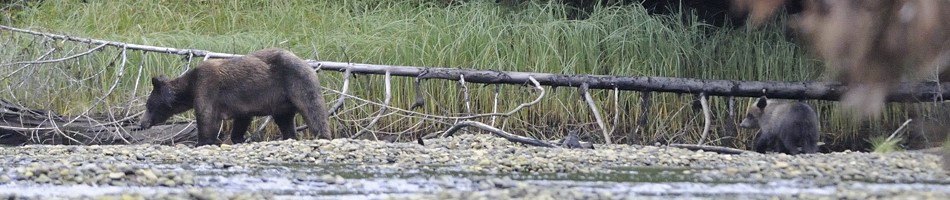
In reviewing Google Earth it seems that there are some logging roads leading from this floating camp across to Wyclese Lagoon, which is the “lake” (I’m not sure if it is salty or not) between Long Lake and Smith Inlet. So, if I could walk along this road then I should be able to avoid any bushwhacking. It is 12 km long and I have contacted the Ministry of Forests who says that it should be passable. The only problem is this report which I remember from when I first wanted to go on my trip a couple years ago. So, remember yesterday when I said that we have little to fear from bears … well, apparently that’s not true here…. It seems that this bear was hanging around this very area through which the road goes. Hopefully it will have moved on by then, and I don’t know why those forest workers didn’t have bear spray with them.
So if this option pans out, which seems likely, then I will just build some sort of wheeled trailer for my kayak, inflate it up, and walk the 12 kilometers to Wyclese Lagoon while towing my loaded kayak. That shouldn’t take more than two days. From there I will go up into Long Lake and see the estuary at its head. And then only a few kilometers back from there is another road which leads straight over to Smith Inlet, near its head. From there I would head to the Nekite Estuary and go on a grizzly tour. This route would involve little backtracking and would be a great way to get across this terrain. The other interesting thing is that these logging roads would be a limited time offer. They are a few years old and are no longer active. This means that within a short time they will be overgrown with alder and impassable.

The road leading from Mereworth Sound to Wyclese Lagoon
As I approached the turn in the inlet I made more videos of me paddling along the shore in and out of the coves and under the overhanging cedar trees. When I rounded the corner the sun angle changed and the video wasn’t good anymore so I turned it off. I passed by the little island where I camped on the way in. It was low tide and there was only a foot of water separating it from the mainland across a tiny little channel. It was so shallow I was wondering if I’d ground my boat. So I don’t think I should have felt so safe from bears that night! Ah, it’s all psychological though. The wind started to pick up a bit but I crossed over the inlet to Pack Lake and made it to the cute logging camp with the patriotic flag. No one was home. I had the place to myself!

I was going to be in for a little bit of luxury tonight. This was a neat place to explore, with all the rustic floating cedar buildings. The important buildings were locked. There was a hose on the main dock, and in the hot sun, the water was warm. I had a hot shower! I also used the sunshine and set up my solar panel for a couple hours.


It looked like the people had just left. Actually, I am guessing that the boats I passed on my way in a few days ago were probably coming from here because there is nowhere else up this inlet they would be. There were colourful flower pots all over the place, including on the land which was connected by a narrow ramp and staircase. Up on land was where all the heavy equipment was kept. A log loading tower was used to transfer the logs into the water to be hauled out.
I wanted to catch some fish so I dropped my buzzbomb down to the sea floor in between the floating logs. I caught small rockfish and threw them back. I tried at the outer edge of the complex and it was deep, probably about 60 feet. I ended up catching a few keepers an on one cast, which turned out to be my final one, I caught something BIG. This thing did not want to come up. I got really exciting and wondered what it was. I had to laugh when it got to the surface and I saw that it was a dogfish, a type of shark which is really common around here and generally thought to be a nuisance.
Dogfish meat is edible but you have to prepare it properly first. This is because sharks don’t excrete urea like higher fishes do and therefore their meat tastes like urine unless you soak it in some mild acid for a while first to neutralize it first (like lemon juice or vinegar); since I had nothing I decide to throw it back. Plus, I didn’t want to kill it and it was way too much anyways; it was almost a meter long. In Europe they use dogfish for fish ‘n chips, because they know how to prepare it. Here, we don’t seem to.
The problem was that this guy was being quite aggressive and hopelessly wrapping itself up. I couldn’t unwind it and it was doing more damage with every movement. I didn’t actually catch it by the mouth; I snagged it in the eye it turns out. Luckily it wasn’t in the eyeball, just the socket so I cut the line and untangled it. It had a gash on its back but other than that it was fine and should recover well. I put it in the water on a log and waited for it to recover and swim away on its own accord. Away it went.


There were also swallows nesting in the buildings and these were flying around all over the place catching insects. They always liven the place up and make it more friendly. I remembered Shoal Bay. I could get quite close when they rested on the wires but the sun angle wasn’t the best so I didn’t get as good shots as I hoped I would.


The spicy rockfish was good and I went to bed satisfied. My sleeping bag was getting pretty disgusting though.


For some reason I don’t remember seeing that hole. You’d think I’d put my food a safer distance away from it.


very nice trip id love to do this. arnt those buildings a bit spooky? haha
November 25, 2013 at 11:40 am